Editing in ArcMap > Editing topology
Making new features with topology tools(ArcInfo and ArcEditor only) |
|
|
Release 9.1
Last modified January 25, 2006 |


Print all topics in : "Editing topology" |
About making new features with topology tools
You can use topology tools to make new features from existing ones. In ArcCatalog, you can create a whole new polygon feature class from an input set of line features. In ArcMap, you can construct new polygon features from the intersection of selected existing line and polygon features or create new line features by splitting selected line features where they cross each other.
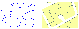
In ArcCatalog, the Polygon Feature Class From Lines command takes one or more existing line or polygon feature classes in a feature dataset and creates new polygon features from the closed shapes that are defined by the intersection of all the lines or polygon edges.
You have the option to use a point feature class to supply attributes for the new polygons. If a point falls within one of the new polygons, the polygon is assigned the points attributes.
In ArcMap, the Construct Features tool ![]() takes selected features from one or more feature classes and creates new features in the target feature class. The tool uses the input geometries of the selected features to construct polygons or lines following polygon boundaries, depending on the geometry of the target feature class.
takes selected features from one or more feature classes and creates new features in the target feature class. The tool uses the input geometries of the selected features to construct polygons or lines following polygon boundaries, depending on the geometry of the target feature class.
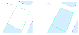
You can use this tool to build parcel polygons from selected lot line features or lake shorelines from selected lake polygon features.
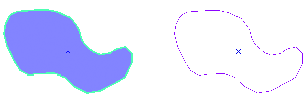
You can also use the Planarize tool to create separate line features from selected touching or crossing line features. This can be useful when you have nontopological line work that has been spaghetti digitized or imported from a computer-aided design (CAD) drawing.
Sometimes you need to create polygon features from line feature data. For example, you might have digitized the boundaries of a set of features into a line feature class, or you may have only been able to obtain line features from a data provider. Perhaps you have a detailed coastline feature class that you would like to use to update some existing, less detailed data. In ArcCatalog, the Polygon Feature Class From Lines tool lets you create new polygon features from line and polygon features in one or more feature classes. You have the option of specifying a point feature class that will supply attributes for the new polygon features.
Sometimes you need to create new features from the geometry of existing features. For example, you might need to create a new parcel feature from some parcel boundary lines or some parcel boundary lines from parcel features. In ArcMap, you can select features and use their geometry to create new polygons or lines in the Editor Target Feature Class. You can create new features from existing features' geometry using the Construct Features tool.
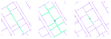
You can create multiple line features by splitting longer features at the places where they intersect using the Planarize Lines command ![]() . When Planarize is used on a multipart line feature, it is split at the point of intersection into a new feature.
. When Planarize is used on a multipart line feature, it is split at the point of intersection into a new feature.
How to make new features with topology tools
Creating a polygon feature class from lines (ArcInfo and ArcEditor only)
- In ArcCatalog, navigate to the dataset in which you want to create a polygon feature class from an existing line feature class.
- Right-click the dataset, point to New, and click Polygon Feature Class From Lines.
- Type a name for the new polygon feature class.
- Check the line feature classes that you want to be considered in creating the polygons.
- Click OK.
Optionally, type a cluster tolerance. The default cluster tolerance is the minimum possible cluster tolerance.
Optionally, choose a point feature class in the dataset to provide attributes for the polygons.
Constructing polygons from the geometry of other features
- In ArcMap, click the Edit tool
 on the Editor toolbar.
 - Select the features whose geometry you want to use to construct new polygon features.
- On the Editor toolbar, click the Task dropdown arrow and click Create New Feature.
- On the Editor toolbar, click the Target dropdown arrow and click the polygon feature class in which you want to create a new feature.
- On the Topology toolbar, click the Construct Features button
 .
. - Click OK.
Optionally, type a cluster tolerance.
Optionally, check the box to consider existing features of the target layer in the current extent.
This will use the boundaries of existing polygons as input geometry and will split such features where selected lines or polygons cross them.
The new features are created in the target feature class.
Constructing lines from the geometry of other features
- In ArcMap, click the Edit tool on the Editor toolbar.
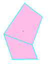
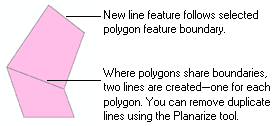
- Select the features whose geometry you want to use to construct new line features. In the graphic, the geometry of polygon features is being used to construct new lines.
- On the Editor toolbar, click the Task dropdown arrow and click Create New Feature.
- On the Editor toolbar, click the Target dropdown arrow and click the line feature class in which you want to create a new feature.
- On the Topology toolbar, click the Construct Features button .
- Click OK.
Optionally, type a cluster tolerance.
Optionally, check the box to consider existing features of the target layer in the current extent.
This will use existing lines as input geometry and split such features where selected lines or polygons cross them.
The new features are created in the target feature class.
Two lines are created where polygons share boundaries.
| Tip |
|
Using Planarize to split lines at intersections
- In ArcMap, click the Edit tool on the Editor toolbar.
- Select the line features you want to split at intersections.
- Click the Planarize Lines button
 on the Topology toolbar.
 - Optionally, type a cluster tolerance.
- Click OK.
The lines are split into new features where they intersect.
Planarize also removes overlapping line segments—such as those created by constructing lines from polygons that have shared boundaries.