Extensions > Spatial Analyst > Analysis concepts in Spatial Analyst > Hydrologic analysis
Identifying stream networks |
|
|
Release 9.1
Last modified April 19, 2005 |


Print all topics in : "Hydrologic analysis" |
- About performing analysis in Spatial Analyst
- Understanding drainage systems
- Exploring Digital Elevation Models (DEM)
- Deriving runoff characteristics
- Creating a depressionless DEM
- Calculating flow accumulation
- Determining flow direction
- Delineating watersheds
- Hydrologic analysis sample applications
- An overview of the Hydrology tools
Stream networks can be delineated from a digital elevation model (DEM) using the output from the Flow Accumulation function. Flow accumulation in its simplest form is the number of upslope cells that flow into each cell. By applying a threshold value to the results of Flow Accumulation using Map Algebra (or the Con tool in Geoprocessing), a stream network can be delineated. For example, the expression to create a raster where the value 1 represents a stream network on a background of NoData could be:
streamnet = con (flowacc > 100, 1)
or
streamnet = setnull (flowacc < 100, 1)
In both examples, all cells with more than 100 cells flowing into them are assigned 1, and all other cells are assigned NoData. For future processing, it is important that the stream network, a set of raster linear features, be represented as values on a background of NoData. Once created, the stream network can be further analyzed using the Stream Order, Stream Link, and Stream to Feature (or Map Algebra StreamLine) functions, for ordering (ranking) the streams, assigning unique IDs to stream links, or creating a feature dataset. Determining a threshold value that represents where a permanent stream or stream channel begins is affected not only by contributing area but also possibly by climate, slope, and soil characteristics. For more information on stream channel initiation, refer to Tarboton and Bras (1991).
Stream ordering is a method of assigning a numeric order to links in a stream network. This order is a method for identifying and classifying types of streams based upon their number of tributaries. Some characteristics of streams can be inferred by simply knowing their order.
For example, first-order streams are dominated by overland flow of water; they have no upstream concentrated flow. Because of this, they are most susceptible to nonpoint source pollution problems and can derive more benefit from wide riparian buffers than other areas of the watershed.
The Stream Order function has two methods you can use to assign orders. These are the methods proposed by Strahler (1957) and Shreve (1966).
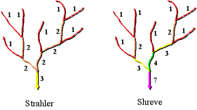
In both methods, the most upstream stream segments, or exterior links, are always assigned an order of 1. In the Strahler method, stream order increases when streams of the same order intersect. Therefore the intersection of two first-order links will create a second-order link, and the intersection of two second-order links will create a third-order link. The intersection of two links of different orders, however, will not result in an increase in order. For example, the intersection of a first-order and second-order link will not create a third order link, but will retain the order of the highest ordered link. The Strahler method is the most common stream ordering method. Be aware, however, that because this method only increases in order at intersections of the same order, it does not account for all links and can be sensitive to the addition or removal of links.
The Shreve method accounts for all links in the network. As with the Strahler method, all exterior links are assigned an order of 1. For all interior links in the Shreve method, however, the orders are additive. For example, the intersection of two first-order links creates a second-order link, the intersection of a first- and second-order link creates a third-order link, and the intersection of a second- and third-order link creates a fifth-order link.
Because the orders are additive, the numbers from the Shreve method are sometimes referred to as magnitudes instead of orders. The magnitude of a link in the Shreve method is the number of upstream links.
The Stream Link function allows you to assign unique values to each of the links in a raster linear network. This is most useful as input to the watershed function to quickly create watersheds based on stream junctions. It can also be useful for attaching related attribute information to individual segments of a stream.
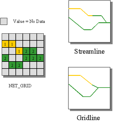
A raster linear network can be accurately converted to features representing the linear network using the Stream to Feature function. The vectorization algorithm is designed primarily for vectorization of raster stream networks or any other raster representing a raster linear network for which directionality is known. In the output feature dataset, all arcs will point downstream.
The Stream to Feature algorithm is optimized to use a direction raster to aid in vectorizing intersecting and adjacent cells. With Stream to Feature, it is possible for two adjacent linear features of the same value to be vectorized as two parallel lines instead of being lumped into a single line as they would when using other vectorization methods.