Show Navigation
|
Hide Navigation
How Union (Analysis) works |
|
|
Release 9.2
Last modified January 13, 2009 |


|
Union calculates the geometric intersection of any number of feature classes and feature layers.
All inputs must be of a common geometry type and the output will be of that same geometry type. This means that a number of polygon feature classes and feature layers can be unioned together. The output features will have the attributes of all the input features that they overlap.
Union does the following:
- Determines the spatial reference for processing. This will also be the output spatial reference. For details on how this is done, see Spatial Reference. All the input feature classes are projected (on the fly) into this spatial reference.
- Cracks and clusters the features. Cracking inserts vertices at the intersection of feature edges; clustering snaps together vertices that are within the xy tolerance.
- Discovers geometric relationships (overlap) between features from all feature classes.
- Writes the new features to the output.
To explicitly control the output spatial reference (coordinate system and domains), set the appropriate environments, the Output Z Aware, and Output M Aware as desired. Note that the spatial reference used during processing is the same as the output spatial reference; therefore, all Input Features must be within the X, Y, Z, and M domains.
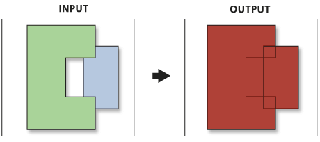
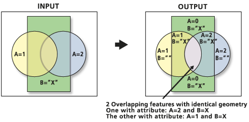
Union can run with a single input feature class or layer. In this case, instead of discovering overlap between the polygon features from the different feature classes or layers, it will discover the overlap between features within the single input. The areas where features overlap will be separated into new features with all the attribute information of the input feature. The area of overlap will always generate two identical overlapping features, one for each of the features that participates in that overlap.
Below is an example of Union with features within a feature class that overlap. In this case, the area of overlap will be duplicated to maintain all the attributes and areas. To recreate the overlapping features, use the Dissolve tool on the feature class produced by Union, and dissolve by all fields except FID.
Below is an example of the result of executing Union with the Gaps Allowed parameter unchecked. A polygon feature is created that would otherwise be left empty. The "gap" features can be identified by doing an attribute query of all the input feature's FID fields = -1.