Goodes Homolosine |
|
|
Release 9.2
Last modified August 3, 2007 |


|
Description
The Goode's Homolosine map projection is designed to minimize distortion for the entire world. It is an interrupted pseudocylindrical equal area projection. John Paul Goode developed the projection in 1925.
Projection method
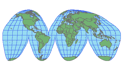
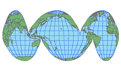
Goode's homolosine projection is a combination of the Mollweide and sinusoidal projections. The Mollweide projection is used for north of 40° 44' and south of -40° 44' approximately. The sinusoidal projection is used between those two latitude values for the equatorial part of the world. Both projections are equal area and pseudocylindrical. The projections are interrupted so that either the land masses except for Antarctica or the oceans are connected.
Linear graticules
All latitudes are straight lines. There are six straight longitude lines due to the interrupted nature of the projection. Each lobe has its own central meridian, although the overall central meridian is zero. You can change the overall central meridian but that will cause the land masses or oceans do no longer be contiguous. For the land-oriented version, the straight longitude values are -100 and 30 in the northern hemisphere and -160, -60, 20, and 140 in the southern hemisphere. The ocean-oriented version uses -140, -10, and 130 in the northern hemisphere and -100, 20, and 140 in the southern hemisphere.
Properties
Shape
No distortion along the central meridians of the interrupted lobes and the equator of the sinusoidal portion (between +/-40° 44').
Area
Areas are represented accurately.
Direction
Local angles are correct along the central meridians of the lobes and the equator in the sinusoidal portion but distorted elsewhere.
Distance
The scale along all parallels in the sinusoidal part (between +/-40° 44') and the central meridians of the lobes of the projection are accurate.
Limitations
Useful only as a world map.
Uses and applications
Used for an equal area world map, mainly for raster data. The USGS EROS data center provides data in Goode's Homolosine.
Parameters
Desktop
- False Easting
- False Northing
- Central Meridian
- Option
The Option parameter is used to set the land or ocean versions. Use 1 (one) for the uninterrupted land masses. Use 2 (two) for the uninterrupted ocean version.