Show Navigation
|
Hide Navigation
You are here:
Map projections and coordinate systems > Supported map projections
Map projections and coordinate systems > Supported map projections
Aitoff |
|
|
Release 9.2
Last modified August 3, 2007 |


Print all topics in : "Supported map projections" |
Related Topics
Description
A compromise projection developed in 1889 for use with world maps.
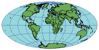
Projection method
Modified azimuthal. Meridians are equally spaced and concave toward the central meridian. The central meridian is a straight line and half the length of the equator. Parallels are equally spaced curves, concave toward the poles.
Linear graticules
The equator and the central meridian.
Properties
Shape
Distortion is moderate.
Area
Moderate distortion.
Direction
Generally distorted.
Distance
The equator and central meridian are at true scale.
Limitations
Neither conformal nor equal area. Useful only for world maps.
Parameters
Desktop
- Supported on spheres only
- False Easting
- False Northing
- Central Meridian
Workstation
- Radius of the sphere of reference
- Longitude of Central Meridian
- False Easting (meters)
- False Northing (meters)
- Supported on spheres only