Show Navigation
|
Hide Navigation
You are here:
Map projections and coordinate systems > Supported map projections
Map projections and coordinate systems > Supported map projections
Fuller |
|
|
Release 9.2
Last modified August 3, 2007 |


Print all topics in : "Supported map projections" |
Related Topics
Description
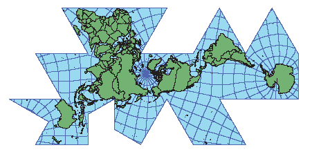
The final version was described by Buckminster Fuller in 1954. For more information, refer to the Buckminster Fuller Institute Website at www.bfi.org.
Projection method
This projection converts the globe into a 20-sided figure called an icosahedron. Each side is a geodesic triangle that is then flattened into a two-dimensional triangle. The facets of the icosahedron are unfolded in a specific manner to keep the land masses unbroken.
Lines of contact
The tangent lines are the facet edges.
Linear graticules
In general, neither latitude nor longitude lines are straight.
Properties
Shape
Distortion increases as the distance from the facet edges increases. Because the Fuller projection is comprised of 20 facets that are projected individually, overall shape distortion is low.
Area
Distortion increases as the distance from the facet edges increases.
Direction
Generally directions are distorted, depending on the orientation of a facet. Angles within a facet are slightly distorted due to the flattening of the geodesic triangle.
Distance
The scale is correct along the facet edges.
Limitations
The north direction is not upright. It is difficult to identify directions without a graticule on the map.
Uses and applications
Best used for display and educational uses.
Parameters
Desktop
- False Easting
- False Northing
- Option