Map projections and coordinate systems > Supported map projections
Geocentric Coordinate System |
|
|
Release 9.2
Last modified August 3, 2007 |


Print all topics in : "Supported map projections" |
Description
The geocentric coordinate system is not a planar coordinate system based on a map projection. It is a geographic coordinate system in which the earth is modeled as a sphere or spheroid in a right-handed X,Y,Z system measured from the center of the earth.
The X-axis points to the prime meridian, the Y-axis points 90° away in the equatorial plane, and the Z-axis points in the direction of the North Pole.
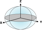
A geocentric coordinate system is similar to a geographic coordinate system based on latitude and longitude, which measures angles from the earth's center
Uses and applications
The geocentric coordinate system is used internally as an transient system. It is used as a framework for calculations as part of several geographic (datum) transformation methods.
Learn more about geographic transformation methods