Show Navigation
|
Hide Navigation
You are here:
Map projections and coordinate systems > Supported map projections
Map projections and coordinate systems > Supported map projections
Great Britain National Grid |
|
|
Release 9.2
Last modified August 3, 2007 |


Print all topics in : "Supported map projections" |
Related Topics
Description
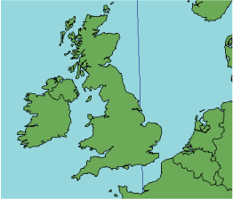
This is a Transverse Mercator projected on the Airy spheroid. The central meridian is scaled to 0.9996. The origin is 49° N and 2° W.
Learn more about Transverse Mercator projection
Projection method
Cylindrical, transverse projection with the central meridian centered along a particular region.
Lines of contact
Two lines parallel with and 180 km from the central meridian at 2° W.
Linear graticules
The central meridian.
Properties
Shape
Conformal; therefore, small shapes are maintained accurately.
Area
Distortion increases beyond Great Britain as the distance from the central meridian increases.
Direction
Local directions are accurately maintained.
Distance
Scale is accurate along the lines of secancy 180 km from the central meridian. Scale is compressed between them and expanded beyond them.
Limitations
Suitable for Great Britain. Limited in east–west extent.
Uses and applications
The national coordinate system for Great Britain; used for large-scale topographic mapping.
Parameters
Workstation
- Projection-specific parameters are set by the software.