Show Navigation
|
Hide Navigation
You are here:
Map projections and coordinate systems > Supported map projections
Map projections and coordinate systems > Supported map projections
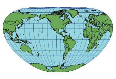
Loximuthal |
|
|
Release 9.2
Last modified August 3, 2007 |


Print all topics in : "Supported map projections" |
Related Topics
Description
Karl Siemon created this pseudo cylindrical projection in 1935. This projection was also presented in 1966 by Waldo Tobler. Loxodromes, or rhumb lines, are shown as straight lines with the correct azimuth and scale from the intersection of the central meridian and the central parallel.
Projection method
Pseudo cylindrical. All parallels are straight lines, and all meridians are equally spaced arcs except the central meridian, which is a straight line. The poles are points.
Linear graticules
The parallels and central meridian.
Properties
Shape
Shape is generally distorted. As the value of the central parallel increases from the equator, the overall shape of the world becomes more distorted.
Area
Generally distorted.
Direction
Directions are true only at the intersection of the central meridian and central latitude. Direction is distorted elsewhere.
Distance
Scale is true along the central meridian. It is constant along any latitude. The opposite latitude has a different scale if the central parallel isn't the equator.
Limitations
Useful only to show loxodromes.
Uses and applications
Suitable for displaying loxodromes.
Parameters
Desktop
- False Easting
- False Northing
- Central Meridian
- Central Parallel
- Supported on spheres only