Map projections and coordinate systems > Supported map projections
Mercator |
|
|
Release 9.2
Last modified August 3, 2007 |


Print all topics in : "Supported map projections" |
Description
Originally created to display accurate compass bearings for sea travel. An additional feature of this projection is that all local shapes are accurate and clearly defined.
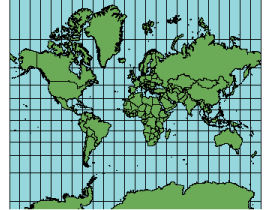
Projection method
Cylindrical projection. Meridians are parallel to each other and equally spaced. The lines of latitude are also parallel but become farther apart toward the poles. The poles cannot be shown.
Lines of contact
The equator or two latitudes symmetrical around the equator.
Linear graticules
All meridians and all parallels.
Properties
Shape
Conformal. Small shapes are well represented because this projection maintains the local angular relationships.
Area
Any straight line drawn on this projection represents an actual compass bearing. These true direction lines are rhumb lines and generally do not describe the shortest distance between points.
Direction
Any straight line drawn on this projection represents an actual compass bearing. These true direction lines are rhumb lines and generally do not describe the shortest distance between points.
Distance
Scale is true along the equator or along the secant latitudes.
Limitations
The poles cannot be represented on the Mercator projection. All meridians can be projected, but the upper and lower limits of latitude are approximately 80° N and S. Large area distortion makes the Mercator projection unsuitable for general geographic world maps.
Uses and applications
- Standard sea navigation charts (direction).
- Other directional uses: air travel, wind direction, ocean currents.
- Conformal world maps.
The best use of this projection's conformal properties applies to regions near the equator such as Indonesia and parts of the Pacific Ocean.
Parameters
Desktop
- False Easting
- False Northing
- Central Meridian
- Standard Parallel 1
Workstation
- Longitude of Central Meridian
- Latitude of true scale
- False Easting (meters)
- False Northing (meters)