Show Navigation
|
Hide Navigation
You are here:
Map projections and coordinate systems > Supported map projections
Map projections and coordinate systems > Supported map projections
Miller Cylindrical |
|
|
Release 9.2
Last modified August 3, 2007 |


Print all topics in : "Supported map projections" |
Related Topics
Description
This projection is similar to the Mercator projection except that the polar regions are not as areally distorted. Spacing between lines of latitude as they approach the poles is less than in the Mercator projection. It decreases the distortion in area, but the compromise introduces distortion in local shape and direction.
Learn more about the Mercator projection
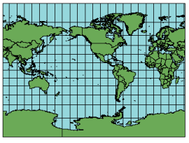
Projection method
Cylindrical projection. Meridians are parallel and equally spaced, lines of latitude are parallel, and the distance between them increases toward the poles. Both poles are represented as straight lines.
Line of contact
The equator.
Linear graticules
All meridians and all parallels.
Properties
Shape
Minimally distorted between 45th parallels, increasingly toward the poles. Land masses are stretched more east–west than they are north–south.
Area
Distortion increases from the equator toward the poles.
Direction
Local angles are correct only along the equator.
Distance
Correct distance is measured along the equator.
Limitations
Useful only as a world map.
Uses and applications
General-purpose world maps.
Parameters
Desktop
- False Easting
- False Northing
- Central Meridian
- Supported on spheres only
Workstation
- Radius of the sphere of reference
- Longitude of Central Meridian
- False Easting (meters)
- False Northing (meters)
- Supported on spheres only