Map projections and coordinate systems > Supported map projections
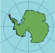
Orthographic |
|
|
Release 9.2
Last modified August 3, 2007 |


Print all topics in : "Supported map projections" |
Description
This perspective projection views the globe from an infinite distance. This gives the illusion of a three-dimensional globe. Distortion in size and area near the projection limit appears more realistic than almost any other projection, except the Vertical Near-Side Perspective.
Projection method
Planar perspective projection, viewed from infinity. On the polar aspect, meridians are straight lines radiating from the center, and the lines of latitude are projected as concentric circles that become closer toward the edge of the globe. Only one hemisphere can be shown without overlapping.
Point of contact
A single point located anywhere on the globe.
Linear graticules
- All aspects—the central meridian of the projection.
- Equatorial aspect—all lines of latitude.
- Polar aspect—all meridians.
Properties
Shape
Minimal distortion near the center; maximal distortion near the edge.
Area
The areal scale decreases with distance from the center. Areal scale is zero at the edge of the hemisphere.
Direction
True direction from the central point.
Distance
The radial scale decreases with distance from the center and becomes zero on the edges. The scale perpendicular to the radii, along the parallels of the polar aspect, is accurate.
Limitations
Limited to a view 90° from the central point, a global hemisphere.
Uses and applications
Uses of this projection are aesthetic more than technical. The most commonly used aspect for this purpose is the oblique.
Parameters
Desktop
- False Easting
- False Northing
- Longitude of center
- Latitude of center
- Supported on spheres only
Workstation
- Radius of the sphere of reference
- Longitude of center of projection
- Latitude of center of projection
- False Easting (meters)
- False Northing (meters)
- Supported on spheres only