Map projections and coordinate systems > Supported map projections
Perspective |
|
|
Release 9.2
Last modified August 3, 2007 |


Print all topics in : "Supported map projections" |
Description
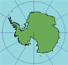
Also known as Vertical Near-Side Perspective or Vertical Perspective, this projection is similar to the Orthographic projection in that its perspective is from space. In this projection, the perspective point is not an infinite distance away; instead, you can specify the distance. The overall effect of this projection is that it looks like a photograph taken vertically from a satellite or space vehicle.
Learn more about the Orthographic projection
Projection method
Planar perspective projection. The distance above the earth is variable and must be specified before the projection can be calculated. The greater the distance, the more closely this projection resembles the Orthographic projection. All aspects are circular projections of an area less than a hemisphere.
Point of contact
A single point anywhere on the globe.
Linear graticules
- All aspects—the central meridian of the projection.
- Polar aspect—all meridians.
- Equatorial aspect—the equator.
Properties
Shape
Minimally distorted near the center, increasing toward the edge.
Area
Minimally distorted near the center; the area scale then decreases to zero on the edge or horizon.
Direction
True directions from the point of tangency.
Distance
Radial scale decreases from true scale at the center to zero on the projection edge. The scale perpendicular to the radii decreases, but not as rapidly.
Limitations
The actual range depends on the distance from the globe. In all cases, the range is less than 90° from the center.
Uses and applications
Used as an aesthetic presentation rather than for technical applications.
Parameters
Desktop
- Use Vertical Near-Side Perspective.
Learn more about the Vertical Near-Side Perspective projection
Workstation
- Radius of the sphere of reference
- Height of perspective point above sphere
- Longitude of center of projection
- Latitude of center of projection
- False Easting (meters)
- False Northing (meters)
- Supported on spheres only