Map projections and coordinate systems > Supported map projections
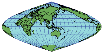
Sinusoidal |
|
|
Release 9.2
Last modified August 3, 2007 |


Print all topics in : "Supported map projections" |
Description
Also known as Sanson–Flamsteed—as a world map, this projection maintains equal area despite conformal distortion. Alternative formats reduce the distortion along outer meridians by interrupting the continuity of the projection over the oceans and by centering the continents around their own central meridians, or vice versa.
Projection method
A pseudo cylindrical projection where all parallels and the central meridian are straight. The meridians are curves based on sine functions with the amplitudes increasing with the distance from the central meridian.
Linear graticules
All lines of latitude and the central meridian.
Properties
Shape
No distortion along the central meridian and the equator. Smaller regions using the interrupted form exhibit less distortion than the uninterrupted sinusoidal projection of the world.
Area
Areas are represented accurately.
Direction
Local angles are correct along the central meridian and the equator but distorted elsewhere.
Distance
The scale along all parallels and the central meridian of the projection is accurate.
Limitations
Distortion is reduced when used for a single land mass rather than the entire globe. This is especially true for regions near the equator.
Uses and applications
Used for world maps illustrating area characteristics, especially if interrupted.
Used for continental maps of South America, Africa, and occasionally other land masses, where each has its own central meridian.
Parameters
Desktop
- False Easting
- False Northing
- Central Meridian
Workstation
- Radius of the sphere of reference
- Longitude of Central Meridian
- False Easting (meters)
- False Northing (meters)
- Supported on spheres only