Map projections and coordinate systems > Supported map projections
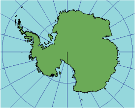
Stereographic |
|
|
Release 9.2
Last modified August 3, 2007 |


Print all topics in : "Supported map projections" |
Description
This projection is conformal.
Projection method
Planar perspective projection, viewed from the point on the globe opposite the point of tangency. Stereographic projects points on a spheroid directly to the plane.
Learn about the Double Stereographic projection
All meridians and parallels are shown as circular arcs or straight lines. Graticular intersections are 90°. In the equatorial aspect, the parallels curve in opposite directions on either side of the equator. In the oblique case, only the parallel with the opposite sign to the central latitude is a straight line; other parallels are concave toward the poles on either side of the straight parallel.
Point of contact
A single point anywhere on the globe.
Linear graticules
- Polar aspect—all meridians.
- Equatorial aspect—the central meridian and the equator.
- Oblique aspect—central meridian and parallel of latitude with the opposite sign of the central latitude.
Properties
Shape
Conformal. Local shapes are accurate.
Area
True scale at center with distortion increasing with distance.
Direction
Directions are accurate from the center. Local angles are accurate everywhere.
Distance
Scale increases with distance from the center.
Limitations
Normally limited to one hemisphere. Portions of the outer hemisphere may be shown, but with rapidly increasing distortion.
Uses and applications
The oblique aspect has been used to map circular regions on the moon, Mars, and Mercury.
Parameters
Desktop
- False Easting
- False Northing
- Central Meridian
- Scale factor
- Latitude of origin
Stereographic_North_Pole
- False Easting
- False Northing
- Central Meridian
- Standard Parallel 1
Stereographic_South_Pole
- False Easting
- False Northing
- Central Meridian
- Standard Parallel 1
Workstation
- Supported on spheres only
- Enter projection type < 1 | 2 >
Type 1 parameters
- Radius of the sphere of reference
- Longitude of center of projection
- Latitude of center of projection
- False Easting (meters)
- False Northing (meters)
Type 2 parameters
- Longitude of Central Meridian
- Latitude of projection's center
- View <EQUATORIAL | NORTHPOLE | SOUTHPOLE>
- Scale factor: equatorial view or Latitude of standard parallel: polar view