Map projections and coordinate systems > Supported map projections
Winkel I |
|
|
Release 9.2
Last modified August 3, 2007 |


Print all topics in : "Supported map projections" |
Description
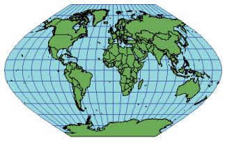
Often used for world maps, the Winkel I projection is a pseudo cylindrical projection that averages the coordinates from the Equirectangular (Equidistant Cylindrical) and Sinusoidal projections. Developed by Oswald Winkel in 1914.
Learn about the Equirectangular (Equidistant Cylindrical) projection
Learn about the Sinusoidal projection
Projection method
Pseudo cylindrical. Coordinates are the average of the Sinusoidal and Equirectangular projections. Meridians are equally spaced sinusoidal curves curving toward the central meridian. The central meridian is a straight line. Parallels are equally spaced straight lines. The length of the poles and the central meridian depends on the standard parallels. If the standard parallel is the equator, Eckert V results.
Learn about the Sinusoidal projection
Learn about the Equirectangular projection
Learn about the Eckert V projection
Linear graticules
The parallels and the central meridian.
Properties
Shape
Generally distorted.
Area
Generally distorted.
Direction
Generally distorted.
Distance
Generally, scale is made true along latitudes 50°28' N and S.
Limitations
Neither conformal nor equal area. Useful only for world maps.
Uses and applications
Developed for use in general world maps. If the standard parallels are 50°28' N and S, the total area scale is correct, but local area scales vary.
Parameters
Desktop
- False Easting
- False Northing
- Central Meridian
- Standard Parallel 1
- Supported on spheres only