Getting started > Fundamentals of GIS data
How maps convey geographic information |
|
|
Release 9.2
Last modified October 27, 2007 |


Print all topics in : "Fundamentals of GIS data" |
Fundamental GIS concepts are closely linked to maps and their contents. In fact, map concepts form the basis for understanding GIS more fully. This topic explores some fundamental map concepts and describes how they are applied and used within GIS.
Maps
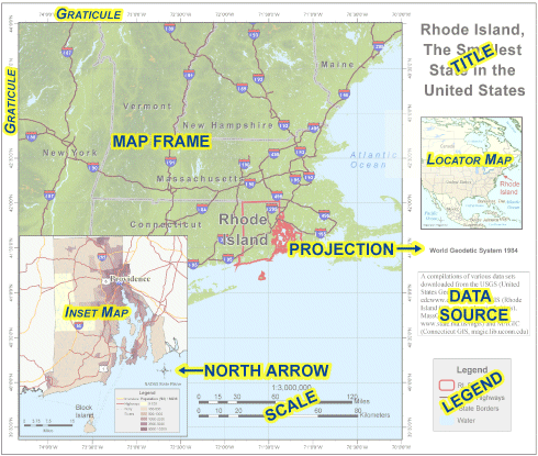
A map is a collection of map elements laid out and organized on a page. Common map elements include the map frame with map layers, a scale bar, north arrow, title, descriptive text, and a symbol legend.
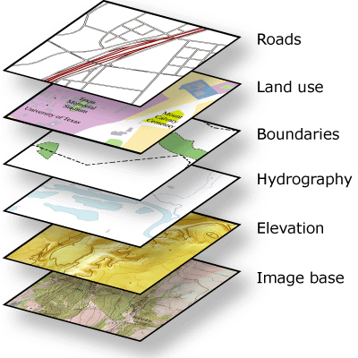
The primary map element is the map frame, and it provides the principal display of geographic information. Within the map frame, geographical entities are presented as a series of map layers that cover a given map extent—for example, map layers such as roads, rivers, place names, buildings, political boundaries, surface elevation, and satellite imagery.
The following graphic illustrates how geographical elements are portrayed in maps through a series of map layers. Map symbols and text are used to describe the individual geographic elements.

Map layers are thematic representations of geographic information, such as transportation, water, and elevation. Map layers help convey information through:
- Discrete features such as collections of points, lines, and polygons
- Map symbols, colors, and labels that help to describe the objects in the map
- Aerial photography or satellite imagery that covers the map extent
- Continuous surfaces such as elevation which can be represented in a number of ways—for example, as a collection of contour lines and elevation points or as shaded relief
Map Layout and composition
Along with the map frame, a map presents an integrated series of map elements laid out and arranged on a page. Common map elements include a north arrow, a scale bar, a symbol legend, and other graphical elements. These elements aid in map reading and interpretation.
The map layout below illustrates how map elements are arranged on a page.

Often, maps include additional elements such as graphs, charts, pictures, and text that help to communicate additional critical information.
Spatial relationships in a map
Maps help convey geographic relationships that can be interpreted and analyzed by map readers. Relationships that are based on location are referred to as spatial relationships. Here are some examples.
- Which geographic features connect to others (for example, Water Street connects with 18th Ave.)
- Which geographic features are adjacent (contiguous) to others (for example, The city park is adjacent to the university.)
- Which geographic features are contained within an area (for example, The building footprints are contained within the parcel boundary.)
- Which geographic features overlap (for example, The railway crosses the freeway.)
- Which geographic features are near others (proximity) (for example, The Courthouse is near the State Capitol.)
- The feature geometry is equal to another feature (for example, The city park is equal to the historic site polygon).
- The difference in elevation of geographic features (for example, The State Capitol is uphill from the water.)
- The feature is along another feature (for example, The bus route follows along the street network.).
Within a map, such relationships are not explicitly represented. Instead, as the map reader, you interpret relationships and derive information from the relative position and shape of the map elements, such as the streets, contours, buildings, lakes, railways, and other features. In a GIS, such relationships can be modeled by applying rich data types and behaviors (for example, topologies and networks) and by applying a comprehensive set of spatial operators to the geographic objects (such as buffer and polygon overlay).