Getting started > Fundamentals of GIS data
Elements of geographic information |
|
|
Release 9.2
Last modified October 27, 2007 |


Print all topics in : "Fundamentals of GIS data" |
There are some universal principles that provide the foundation for how GIS systems represent, operate on, manage, and share geographic information. The purpose of this topic is to provide you with a solid foundation for understanding these key concepts and how ArcGIS employs them.
Like a map, a GIS is layer-based. And like the layers in a map, GIS datasets represent collections of individual features with their geographic locations and shapes as well as with descriptive information stored as attributes.
There are four fundamental types of geographic representations:
- Features (collections or points, lines, and polygons)
- Attributes
- Imagery
- Continuous surfaces (such as elevation)
All of the rich GIS behavior for representing and managing geographic information is based on these fundamental types.
Features - Points, lines, and polygons
Geographic features are representations of things located on or near the surface of the earth. Geographic features can occur naturally (such as rivers and vegetation), can be constructions (such as roads, pipelines, wells, and buildings), and can be subdivisions of land (such as counties, political divisions, and land parcels).
Although there are a number of additional types, geographic features are most commonly represented as points, lines, and polygons.
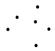
Points define discrete locations of geographic features too small to be depicted as lines or areas, such as well locations, telephone poles, and stream gauges. Points can also represent locations such as address locations, GPS coordinates, or mountain peaks.
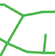
Lines represent the shape and location of geographic objects too narrow to depict as areas (such as street centerlines and streams). Lines are also used to represent features that have length but no area such as contour lines and administrative boundaries. (Contours are interesting, as you'll read later on, because they provide one of a number of alternatives for representing continuous surfaces.)
Polygons are enclosed areas (many-sided figures) that represent the shape and location of homogeneous features such as states, counties, parcels, soil types, and land use zones. In the example below, the polygons represent Parcels.

Attributes
Maps convey descriptive information through map symbols, colors, and labels. Here are some typical examples:
- Roads are displayed based on their road class (for example, line symbols representing divided highways, main streets, residential streets, unpaved roads, and trails).
- Streams and water bodies are drawn in blue to indicate water.
- City streets are labeled with their name and often some address range information.
- Special point and line symbols denote specific features such as rail lines, airports, schools, hospitals, and special facilities.
In a GIS, descriptive attributes are managed in tables, which are based on a series of simple, essential relational database concepts. A relational database provides a simple, universal data model for storing and working with attribute information. DBMSs are inherently open because their simplicity and flexibility enables support for a broad range of applications. Key relational concepts include:
- Descriptive data is organized into tables.
- Tables contain rows.
- All rows in a table have the same columns.
- Each column has a type, such as integer, decimal number, character, date, and so on.
- A series of relational functions and operators (SQL) is available to operate on the tables and their data elements.
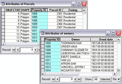
The illustration below shows two tables and how their records can be related to one another using a common field. In the example, the parcels feature class table is linked to the owners table through the common Property ID field.
Imagery
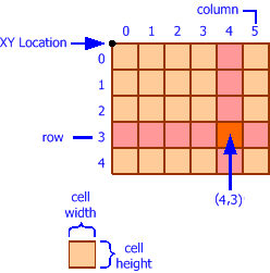
Aerial imagery is a raster data structure obtained from various sensors carried in satellites and aircraft. Imagery is managed as a raster data type composed of cells organized in a grid of rows and columns. In addition to the map projection, the coordinate system for a raster dataset includes its cell size and a reference coordinate (usually the upper left or lower left corner of the grid).
These properties enable a raster dataset to be described by a series of cell values starting in the upper left row. Each cell location can be automatically located using the reference coordinate, the cell size, and the number of rows and columns.
Typical image sources include cameras capable of capturing aerial photographs that can be georeferenced and corrected to ground locations (such as digital ortho photography).
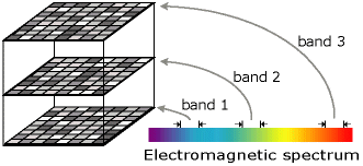
Imagery is also used to collect data in both the visible and non-visible portions of the electromagnetic spectrum. One system is the multispectral scanner carried in LANDSAT satellites that records imagery in seven bands (or ranges) along the electromagnetic spectrum. The measures for each band are recorded in a separate grid. The stack of seven grids makes up a multiband image.
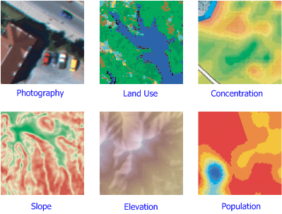
Surfaces
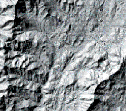
A surface describes an occurrence that has a value for every point on the earth. For example, surface elevation is a continuous layer of values for ground elevation above mean sea level for the entire extent of the dataset. Other surface type examples include rainfall, pollution concentration, and sub-surface representations of geological formations.
Surface representation is somewhat challenging. With continuous datasets, it is impossible to represent all values for all locations. Various alternatives exist for representing surfaces using either features or rasters. Here are some example alternatives for surface representation:
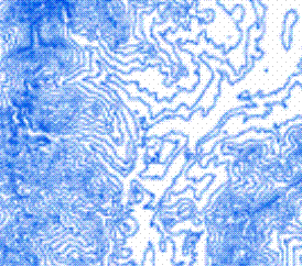
Contour lines—Isolines represent locations having an equal value, such as elevation contours.
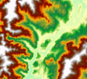
Contour bands—The areas where the surface value is within a specified range, such as bands of average annual rainfall between 25 CM and 50 CM per year.
Raster datasets—A matrix of cells where each cell value represents a measure of the continuous variable. For example, Digital Elevation Models (DEMs) are frequently used to represent surface elevation.
TIN layers—A Triangulated Irregular Network (TIN) is a data structure for representing surfaces as a connected network of triangles. Each triangle node has an XY coordinate and a Z or surface value.
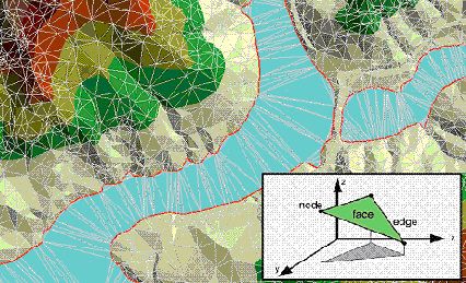
The raster and TIN representations can be used to estimate the surface value for any location using interpolation.