Getting started > Fundamentals of GIS data
How GIS represents and organizes geographic information |
|
|
Release 9.2
Last modified October 27, 2007 |


Print all topics in : "Fundamentals of GIS data" |
Managing features, rasters, attributes, and surfaces in ArcGIS
These four types of geographic information (features, rasters, attributes, and surfaces) are actually managed using three primary GIS data structures:
- Feature classes
- Attribute tables
- Raster datasets
Each of these primary datasets can be extended with additional capabilities to maintain data integrity (for example, using topology), to model geographic relationships (such as network connectivity and flow), and to add advanced behaviors (for example, using TINs).
| Map Layer Types | GIS Datasets |
| Features—points, lines, and polygons | Feature classes |
| Attributes | Tables |
| Imagery | Raster datasets |
| Surfaces | Both features and rasters can be used to provide a number of alternative surface representations:
|
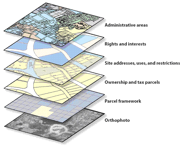
A GIS has a collection of datasets
Typically, a GIS is used for handling several different datasets where each holds data about a particular feature collection (for example, roads) that is geographically referenced to the earth's surface.
A GIS database design is based upon a series of data themes, each having a specified geographic representation. For example, individual geographic entities can be represented as features (such as points, lines, and polygons); as imagery using rasters; as surfaces using features, rasters, or TINs; and as descriptive attributes.
In a GIS, homogeneous collections of geographic objects are organized into data themes such as parcels, wells, buildings, ortho imagery, and raster-based digital elevation models (DEMs). Precisely and simply defined geographic datasets are critical for useful geographic information systems, and the layer-based concept of data themes is a critical GIS concept.
GIS datasets are collections of geographic representations
A dataset is a collection of homogeneous features. Geographic representations are organized in a series of datasets or layers. Most datasets are collections of simple geographic elements such as a road network, a collection of parcel boundaries, soil types, an elevation surface, satellite imagery for a certain date, well locations, and so on.
In a GIS, spatial data collections are typically organized as feature class datasets or raster-based datasets.
Many data themes are best represented by a single dataset such as for soil types or well locations. Other themes, such as a transportation framework, are represented by multiple datasets (such as a separate feature class each for streets, intersections, bridges, highway ramps, railroads, and so on).
Raster datasets are used to represent georeferenced imagery as well as continuous surfaces such as elevation, slope, and aspect.
| Theme | Geographic representation |
| Hydrography | Lines |
| Road centerlines | Lines |
| Vegetation | Polygons |
| Urban areas | Polygons |
| Administrative boundaries | Polygons |
| Elevation contours | Lines |
| Well locations | Points |
| Orthophotography | Raster |
| Satellite imagery | Raster |
| Land parcels | Polygons |
| Parcel tax records | Tables |
Datasets are the organizing principle in a GIS database
The concept of a data theme was one of the early notions in GIS. Historically, GIS practitioners thought about how the geographic information in maps could be partitioned into a series of logical information layers—as more than a random collection of objects. They envisioned homogeneous collections of representations that could be managed as layers and that these data layers could be combined through georeferencing. These early GIS users organized information in various data themes that described the distribution of a phenomenon and how each should be portrayed across a geographic extent.
These layers also provided a protocol for collecting the representations. For example, a data theme could be defined that delineated various areas representing the dominant soil type (that is, a layer collection of soil type polygons). Each and every area (the polygons) in a specified extent could be assigned an explicit soil type, and the soil types could be described using properties or attributes of each polygon.
Each GIS will contain multiple themes for a common geographic area. The collection of themes acts as a stack of layers. Each theme can be managed as an information set independent of other themes. Each has its own representation (as a collection of points, lines, polygons, surfaces, rasters, and so on). Because layers are spatially referenced, they overlay one another and can be combined in a common map display. GIS analysis operations, such as polygon overlay, can fuse information between data layers to discover and work with the derived spatial relationships.
Implications of layer-based data themes
The GIS design concept of layer-based data themes has some key implications:
- All layers must be georeferenced to a place on the earth. This is accomplished by defining the geographic coordinate system for each dataset.
- Layers can be combined in many ways—some that are visual (such as the ordered layers in a map)—and some that employ tool-based operators or "commands". Geographic operators can be used to identify and work with the relationships both within as well as between layers. One key aspect of GIS is that it provides a sophisticated series of operators that work against the georeferenced collection of data layers. GIS users often refer to this as geoprocessing.
- GIS layers can be combined from many sources and many users. In fact, most users are dependent on one another for portions of the data they want to use. Interoperability is fundamental in GIS.
GIS uses many datasets and data types
A GIS will use numerous datasets, each containing its specific representation, often from many organizations. A number of alternative file formats and schemas will be used across a range of systems, but users still have the need to share and re-use each other's data.
Therefore, it is important for GIS datasets to be:
- Simple to use and easy to understand
- Combined easily with other geographic datasets (for example, each has a well-defined spatial reference)
- Effectively compiled and validated
- Clearly documented for content, intended uses, and purposes
Any effective GIS database or file base will adhere to these common principles and concepts regardless of its format. Each GIS requires a mechanism for describing geographic data in these terms along with a comprehensive set of tools to use and manage this information.