Extensions > Spatial Analyst > Spatial Analyst functional reference > Zonal (Spatial Analyst)
ZonalRange |
|
|
Release 9.2
Last modified January 3, 2008 |


Print all topics in : "Zonal (Spatial Analyst)" |
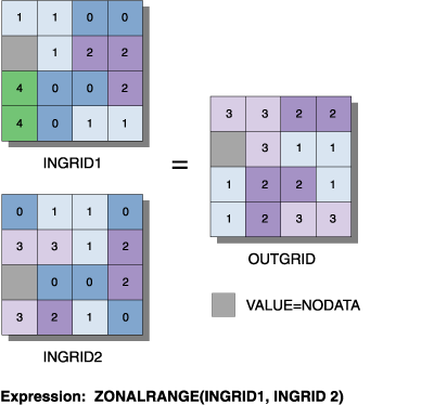
Records, in each output cell, the range of values of all cells in the <value_grid> that belong to the same zone as the output cell. Zones are identified by the values of the cells in the input <zone_grid>.
Illustration
Usage tips
-
The zone raster must be an integer raster.
-
The value raster can be integer or floating point.
-
The data type of the output raster is the same as that of the value raster.
-
The range is defined as:
ZonalRange = ZonalMax - ZonalMin
-
Learn more about how to specify the input raster dataset in the Map Algebra expression of Raster Calculator.
Map Algebra
Command line syntax
See Zonal Statistics
Scripting syntax
See Zonal Statistics
Map Algebra syntax
ZonalRange(<zone_grid>, <value_grid>, {DATA | NODATA})
| Parameter | Explanation |
| <zone_grid> | An integer raster that identifies the zone for each cell.
The zone raster can be an expression resulting in a raster. |
| <value_grid> | An integer or floating-point raster that defines the values of the cells in which the range of the values is to be calculated.
The range of the values of the value raster in each zone will be assigned to every cell in that zone on the output raster. The value raster may be an expression resulting in a raster. |
| {DATA | NODATA} | A keyword defining the manner in which NoData values on the <value_grid> that fall within a zone defined by the <zone_grid> will influence the output results.
|
Map Algebra example
zonalrange(zonegrid, valuegrid)
zonalrange(zonegrid, valuegrid, NODATA)
zonalrange(zonegrid, valuegrid, DATA)
zonalrange(zonegrid, (ingrid1 + ingrid2))
zonalrange((ingrid1 + ingrid2), ingrid3, NODATA)
zonalrange(reclass(ingrid1,tab1), (ingrid2 div ingrid3 * 4))
ArcObjects syntax
See Zonal Statistics