 Print Topics
Elements of geographic information |
|
|
Release 9.2
Last modified October 27, 2007 |


Print all topics in : "[PRINTBOOKS_NAME]" |
There are some universal principles that provide the foundation for how GIS systems represent, operate on, manage, and share geographic information. The purpose of this topic is to provide you with a solid foundation for understanding these key concepts and how ArcGIS employs them.
Like a map, a GIS is layer-based. And like the layers in a map, GIS datasets represent collections of individual features with their geographic locations and shapes as well as with descriptive information stored as attributes.
There are four fundamental types of geographic representations:
Geographic features are representations of things located on or near the surface of the earth. Geographic features can occur naturally (such as rivers and vegetation), can be constructions (such as roads, pipelines, wells, and buildings), and can be subdivisions of land (such as counties, political divisions, and land parcels).
Although there are a number of additional types, geographic features are most commonly represented as points, lines, and polygons.
Points define discrete locations of geographic features too small to be depicted as lines or areas, such as well locations, telephone poles, and stream gauges. Points can also represent locations such as address locations, GPS coordinates, or mountain peaks.

Lines represent the shape and location of geographic objects too narrow to depict as areas (such as street centerlines and streams). Lines are also used to represent features that have length but no area such as contour lines and administrative boundaries. (Contours are interesting, as you¨ll read later on, because they provide one of a number of alternatives for representing continuous surfaces.)
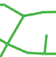
Polygons are enclosed areas (many-sided figures) that represent the shape and location of homogeneous features such as states, counties, parcels, soil types, and land use zones. In the example below, the polygons represent Parcels.

Maps convey descriptive information through map symbols, colors, and labels. Here are some typical examples:
Aerial imagery is a raster data structure obtained from various sensors carried in satellites and aircraft. Imagery is managed as a raster data type composed of cells organized in a grid of rows and columns. In addition to the map projection, the coordinate system for a raster dataset includes its cell size and a reference coordinate (usually the upper left or lower left corner of the grid).
These properties enable a raster dataset to be described by a series of cell values starting in the upper left row. Each cell location can be automatically located using the reference coordinate, the cell size, and the number of rows and columns.
Typical image sources include cameras capable of capturing aerial photographs that can be georeferenced and corrected to ground locations (such as digital ortho photography).
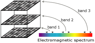
Imagery is also used to collect data in both the visible and non-visible portions of the electromagnetic spectrum. One system is the multispectral scanner carried in LANDSAT satellites that records imagery in seven bands (or ranges) along the electromagnetic spectrum. The measures for each band are recorded in a separate grid. The stack of seven grids makes up a multiband image.
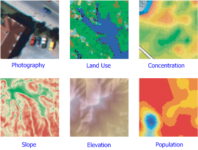
A surface describes an occurrence that has a value for every point on the earth. For example, surface elevation is a continuous layer of values for ground elevation above mean sea level for the entire extent of the dataset. Other surface type examples include rainfall, pollution concentration, and sub-surface representations of geological formations.
Surface representation is somewhat challenging. With continuous datasets, it is impossible to represent all values for all locations. Various alternatives exist for representing surfaces using either features or rasters. Here are some example alternatives for surface representation:
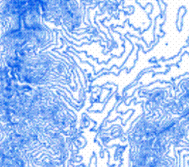
Contour lines—Isolines represent locations having an equal value, such as elevation contours.
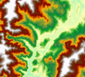
Contour bands—The areas where the surface value is within a specified range, such as bands of average annual rainfall between 25 CM and 50 CM per year.
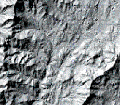
Raster datasets—A matrix of cells where each cell value represents a measure of the continuous variable. For example, Digital Elevation Models (DEMs) are frequently used to represent surface elevation.
TIN layers—A Triangulated Irregular Network (TIN) is a data structure for representing surfaces as a connected network of triangles. Each triangle node has an XY coordinate and a Z or surface value.
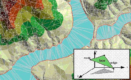
The raster and TIN representations can be used to estimate the surface value for any location using interpolation.
Georeferencing and coordinate systems |
|
|
Release 9.2
Last modified October 27, 2007 |
Print all topics in : "[PRINTBOOKS_NAME]" |
All the elements in a map layer have a specific geographic location and extent that enables them to be located on or near the earth¨s surface. The ability to accurately describe geographic locations is critical in both mapping and GIS. This process is called georeferencing.
Describing the correct location and shape of features requires a framework for defining real-world locations. A geographic coordinate system is used to assign geographic locations to objects. A global coordinate system of latitude-longitude is one such framework. Another is a planar or Cartesian coordinate system derived from the global framework.
Maps represent locations on the earth¨s surface using grids, graticules, and tic marks labeled with various ground locations (both in measures of latitude-longitude and in projected coordinate systems (such as UTM meters). The geographic elements contained in various map layers are drawn in a specific order (on top of one another) for the given map extent.
GIS datasets contain coordinate locations within a global or Cartesian coordinate system to record geographic locations and shapes.
One method for describing the position of a geographic location on the earth¨s surface is using spherical measures of latitude and longitude. They are measures of the angles (in degrees) from the center of the earth to a point on the earth¨s surface. This reference system is often referred to as a geographic coordinate system.
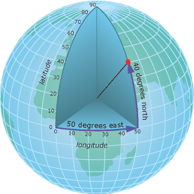
Latitude angles are measured in a north-south direction. The equator is at an angle of 0. Often, the northern hemisphere has positive measures of latitude and the southern hemisphere has negative measures of latitude. Longitude measures angles in an east-west direction. Longitude measures are traditionally based on the Prime Meridian, which is an imaginary line running from the North Pole through Greenwich, England to the South Pole. This angle is Longitude 0. West of the Prime Meridian is often recorded as negative Longitude and east is recorded as positive. For example, the location of Los Angeles, California is roughly Latitude "plus 33 degrees, 56 minutes" and Longitude "minus 118 degrees, 24 minutes."
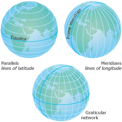
Although longitude and latitude can locate exact positions on the surface of the globe, they are not uniform units of measure. Only along the equator does the distance represented by one degree of longitude approximate the distance represented by one degree of latitude. This is because the equator is the only parallel as large as a meridian. (Circles with the same radius as the spherical earth are called great circles. The equator and all meridians are great circles.)
Above and below the equator, the circles defining the parallels of latitude get gradually smaller until they become a single point at the North and South Poles where the meridians converge. As the meridians converge toward the poles, the distance represented by one degree of longitude decreases to zero. On the Clarke 1866 spheroid, one degree of longitude at the equator equals 111.321 km, while at 60Â latitude, it is only 55.802 km. Since degrees of latitude and longitude don¨t have a standard length, you can¨t measure distances or areas accurately or display the data easily on a flat map or computer screen. Performing GIS analysis and mapping applications requires a more stable coordinate framework, which is provided by projected coordinate systems.
Projected coordinate systems are any coordinate system designed for a flat surface, such as a printed map or a computer screen.
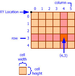
2D and 3D Cartesian coordinate systems provide the mechanism for describing the geographic location and shape of features using x and y values (and, as you will read later, by using columns and rows in rasters).
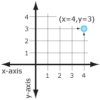
The Cartesian coordinate system uses two axes: one horizontal (x), representing east-west, and one vertical (y), representing north-south. The point at which the axes intersect is called the origin. Locations of geographic objects are defined relative to the origin, using the notation (x,y), where x refers to the distance along the horizontal axis, and y refers to the distance along the vertical axis. The origin is defined as (0,0).
In the illustration below, the notation (4, 3) records a point that is four units over in x and three units up in y from the origin.
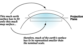
Since the earth is spherical, a challenge faced by cartographers and GIS professionals is how to represent the real world using a flat or planar coordinate system. To understand their dilemma, consider how you would flatten half of a basketball; it can¨t be done without distorting its shape or creating areas of discontinuity. The process of flattening the earth is called projection, hence the term map projection.
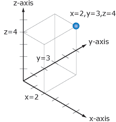
A projected coordinate system is defined on a flat, two dimensional surface. Projected coordinates can be defined for both 2D (x,y) and 3D (x,y,z) in which the x,y measurements represent the location on the earth¨s surface and z would represent height above or below mean sea level.
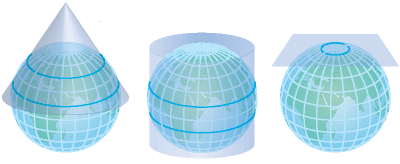
Below are some examples of various methods for deriving planar map projections.
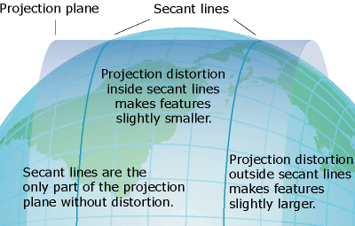
Unlike a geographic coordinate system, a projected coordinate system has constant lengths, angles, and areas across the two dimensions. However, all map projections representing the earth¨s surface as a flat map, create distortions in some aspect of distance, area, shape, or direction.
Users cope with these limitations by using map projections that fit their intended uses, geographic location, and extent. GIS software also can transform information between coordinate systems to support integration and critical workflows.
Many map projections are designed for specific purposes. One map projection might be used for preserving shape while another might be used for preserving the area (conformal versus equal area).
These properties—the map projection (along with Spheroid and Datum), become important parameters in the definition of the coordinate system for each GIS dataset and each map. By recording detailed descriptions of these properties for each GIS dataset, computers can re-project and transform the geographic locations of dataset elements on the fly into any appropriate coordinate system. As a result, it¨s possible to integrate and combine information from multiple GIS layers. This is a fundamental GIS capability. Accurate location forms the basis for almost all GIS operations.
Learn more about Map Projections
How ArcGIS users work with geographic information |
|
|
Release 9.2
Last modified October 27, 2007 |
Print all topics in : "[PRINTBOOKS_NAME]" |
Users work with geographic data in two fundamental ways:
Geographic datasets are the primary object collections that users work with in a GIS. They also represent the most common method for data sharing among GIS users.
Datasets are used as the basis for most GIS operations, and provide the primary data sources for:
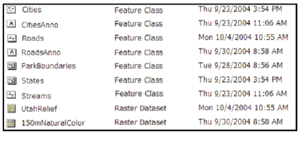
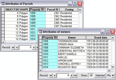
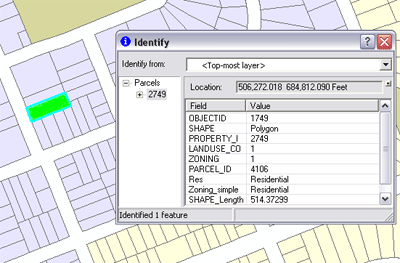
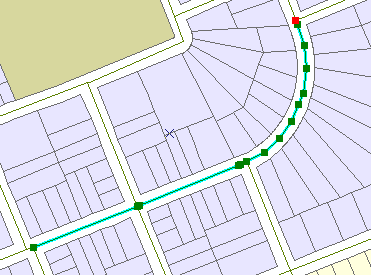
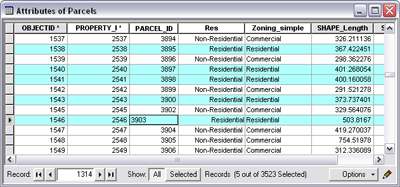
In addition to working with datasets, users also work with the individual elements contained in datasets. These elements include individual features, rows and columns in attribute tables, and individual cells in raster datasets. For example:
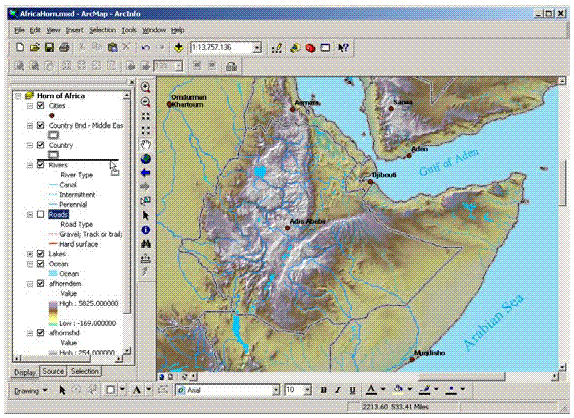
When you identify a parcel by pointing at it, you¨re working with the individual data elements in a dataset:
You work with individual data elements when you edit features, a road centerline in this case:
In tables, users work with descriptive information contained in rows and columns.
How GIS represents and organizes geographic information |
|
|
Release 9.2
Last modified October 27, 2007 |
Print all topics in : "[PRINTBOOKS_NAME]" |
These four types of geographic information (features, rasters, attributes, and surfaces) are actually managed using three primary GIS data structures:
| Map Layer Types | GIS Datasets |
| Features—points, lines, and polygons | Feature classes |
| Attributes | Tables |
| Imagery | Raster datasets |
| Surfaces | Both features and rasters can be used to provide a number of alternative surface representations:
|
Typically, a GIS is used for handling several different datasets where each holds data about a particular feature collection (for example, roads) that is geographically referenced to the earth¨s surface.
A GIS database design is based upon a series of data themes, each having a specified geographic representation. For example, individual geographic entities can be represented as features (such as points, lines, and polygons); as imagery using rasters; as surfaces using features, rasters, or TINs; and as descriptive attributes.
In a GIS, homogeneous collections of geographic objects are organized into data themes such as parcels, wells, buildings, ortho imagery, and raster-based digital elevation models (DEMs). Precisely and simply defined geographic datasets are critical for useful geographic information systems, and the layer-based concept of data themes is a critical GIS concept.
A dataset is a collection of homogeneous features. Geographic representations are organized in a series of datasets or layers. Most datasets are collections of simple geographic elements such as a road network, a collection of parcel boundaries, soil types, an elevation surface, satellite imagery for a certain date, well locations, and so on.
In a GIS, spatial data collections are typically organized as feature class datasets or raster-based datasets.
Many data themes are best represented by a single dataset such as for soil types or well locations. Other themes, such as a transportation framework, are represented by multiple datasets (such as a separate feature class each for streets, intersections, bridges, highway ramps, railroads, and so on).
Raster datasets are used to represent georeferenced imagery as well as continuous surfaces such as elevation, slope, and aspect.
| Theme | Geographic representation |
| Hydrography | Lines |
| Road centerlines | Lines |
| Vegetation | Polygons |
| Urban areas | Polygons |
| Administrative boundaries | Polygons |
| Elevation contours | Lines |
| Well locations | Points |
| Orthophotography | Raster |
| Satellite imagery | Raster |
| Land parcels | Polygons |
| Parcel tax records | Tables |
The concept of a data theme was one of the early notions in GIS. Historically, GIS practitioners thought about how the geographic information in maps could be partitioned into a series of logical information layers—as more than a random collection of objects. They envisioned homogeneous collections of representations that could be managed as layers and that these data layers could be combined through georeferencing. These early GIS users organized information in various data themes that described the distribution of a phenomenon and how each should be portrayed across a geographic extent.
These layers also provided a protocol for collecting the representations. For example, a data theme could be defined that delineated various areas representing the dominant soil type (that is, a layer collection of soil type polygons). Each and every area (the polygons) in a specified extent could be assigned an explicit soil type, and the soil types could be described using properties or attributes of each polygon.
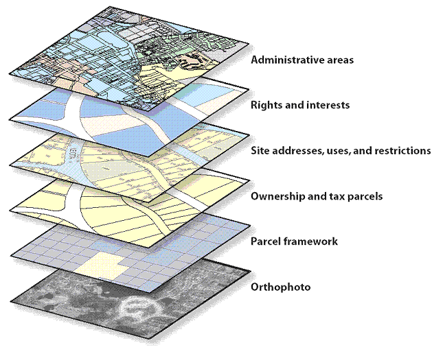
Each GIS will contain multiple themes for a common geographic area. The collection of themes acts as a stack of layers. Each theme can be managed as an information set independent of other themes. Each has its own representation (as a collection of points, lines, polygons, surfaces, rasters, and so on). Because layers are spatially referenced, they overlay one another and can be combined in a common map display. GIS analysis operations, such as polygon overlay, can fuse information between data layers to discover and work with the derived spatial relationships.
The GIS design concept of layer-based data themes has some key implications:
A GIS will use numerous datasets, each containing its specific representation, often from many organizations. A number of alternative file formats and schemas will be used across a range of systems, but users still have the need to share and re-use each other¨s data.
Therefore, it is important for GIS datasets to be:
How maps convey geographic information |
|
|
Release 9.2
Last modified October 27, 2007 |
Print all topics in : "[PRINTBOOKS_NAME]" |
Fundamental GIS concepts are closely linked to maps and their contents. In fact, map concepts form the basis for understanding GIS more fully. This topic explores some fundamental map concepts and describes how they are applied and used within GIS.
A map is a collection of map elements laid out and organized on a page. Common map elements include the map frame with map layers, a scale bar, north arrow, title, descriptive text, and a symbol legend.
The primary map element is the map frame, and it provides the principal display of geographic information. Within the map frame, geographical entities are presented as a series of map layers that cover a given map extent—for example, map layers such as roads, rivers, place names, buildings, political boundaries, surface elevation, and satellite imagery.
The following graphic illustrates how geographical elements are portrayed in maps through a series of map layers. Map symbols and text are used to describe the individual geographic elements.
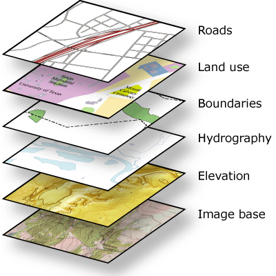
Map layers are thematic representations of geographic information, such as transportation, water, and elevation. Map layers help convey information through:
Along with the map frame, a map presents an integrated series of map elements laid out and arranged on a page. Common map elements include a north arrow, a scale bar, a symbol legend, and other graphical elements. These elements aid in map reading and interpretation.
The map layout below illustrates how map elements are arranged on a page.
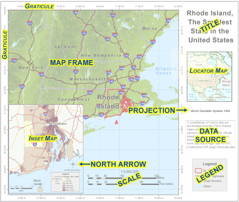
Often, maps include additional elements such as graphs, charts, pictures, and text that help to communicate additional critical information.
Maps help convey geographic relationships that can be interpreted and analyzed by map readers. Relationships that are based on location are referred to as spatial relationships. Here are some examples.
Users work with many data types and data formats in ArcGIS |
|
|
Release 9.2
Last modified October 27, 2007 |
Print all topics in : "[PRINTBOOKS_NAME]" |
ArcGIS supports geographic datasets that are managed in geodatabases as well as in numerous GIS file formats. Geodatabase datasets represent the native data structure for ArcGIS and are the primary data format used for editing and data management. Yet, many additional datasets can be used.
A number of additional file formats are supported. These can be used in ArcGIS much like geodatabase datasets—to create layers in ArcMap and ArcGlobe; as inputs for Geoprocessing operations; to be viewed and queried in charts, maps, globes, and tables; and converted to and from many other GIS formats.
The following table lists some of the dataset file types commonly used in ArcGIS.
| ESRI | Coverage
|
ArcInfo Workstation coverages
|
|
|
Grid | ArcInfo GRID raster format
|
|
|
Tin | ArcInfo triangulated irregular network (TIN) format
|
|
|
Shapefile (SHP) | ESRI shapefile format
|
| Vector | TIGER/Line | U.S. Census Bureau¨s TIGER/Line Files
|
|
|
MIF/MID | MapInfo Vector Interchange File
MapInfo Table Interchange for MIF |
|
|
TAB | MapInfo Native Dataset
|
|
|
VPF | National Geospatial Intelligence Agency¨s Vector Product File format
|
|
|
GML | Open Geospatial Consortium¨s GML Interchange Specification
|
| Raster | IMG | Leica ERDAS Imagine image files
|
|
|
BMP | Bitmap raster format
|
|
|
TIF | TIFF raster format
|
|
|
JPG | JPEG raster compression format
|
|
|
JP2 | JPEG 2000 raster format
|
|
|
SID | MrSID raster format
|
| CAD | DXF | CAD transfer file. Uses ASCII or binary drawing file interchange.
|
|
|
DGN | MicroStation design file format
|
|
|
DWG | AutoCAD drawing file format
|
| Tables | XLS | Excel spreadsheets
|
|
|
DBF | dBase data file format
|
|
|
Info | Arc/Info Workstation INFO tables
|
|
|
MDB | File format for Microsoft¨s Access database
|
|
|
TXT | Text file often used to hold attribute columns delimited by commas or tabs
|
The ArcGIS Data Interoperability extension provides direct read access to dozens of additional spatial data formats not already supported in ArcGIS. For example, you can use the Data Interoperability extension to add support for various GML profiles as well as advanced data formats in DWG/DXF, MicroStation Design, MapInfo MID/MIF, and TAB file types.
You can convert to and from these data types and geodatabases using this extension. More importantly, you can use Data Interoperability to directly use these formats in ArcGIS. Users can drag and drop these and many other external data sources into ArcGIS for general use in mapping, geoprocessing, metadata management, and 3D globe use. For example, you can make use of all the mapping functions available to native ESRI formats inside ArcMap for these data sources—such as viewing features and attributes, identifying features, and making selections.
The ArcGIS Data Interoperability extension is developed and maintained collaboratively by ESRI and Safe Software Inc., the leading GIS interoperability vendor, and is based on Safe Software’s popular Feature Manipulation Engine (FME) product.
The ArcGIS Data Interoperability extension also includes FME Workbench, which contains a series of data transformation tools to build converters for many complex vector data formats.
Learn more about Data Interoperability Extension