Show Navigation
|
Hide Navigation
How Corridor works |
|
|
Release 9.3
Last modified September 7, 2011 |


|
Corridor returns a raster that calculates the sum of the cost distances (accumulative costs) for two input accumulative cost rasters for each cell. The sum of the accumulative costs identifies, for each cell, the least-cost path from one source to another that passes through the cell location.
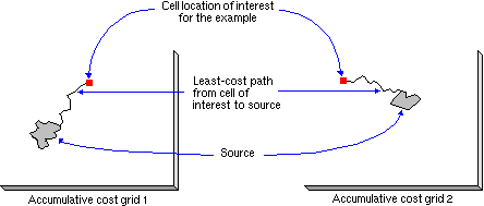
To create a corridor, two cost accumulative rasters must be created using the Cost Distance function (or another cost surface function that produces an accumulative cost surface) and one raster for each source (or set of sources). The diagrams that follow show the cost surfaces being created from a single cell location for demonstration purposes. The procedure actually occurs for each cell location on the input rasters.

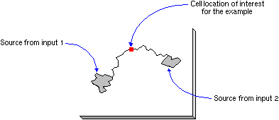
The Corridor function then adds the two accumulative cost surfaces together.

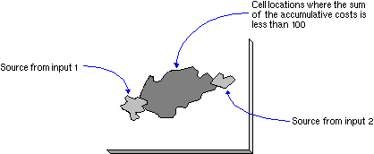
The output raster does not identify a single least-cost path between the two sources but identifies the range of accumulative costs between the sources. If all cells with values less than a maximum accumulated distance (or threshold) are selected from the corridor raster, the resulting output raster will correspond to a swath (or corridor) of cells that do not exceed a specified cost. The resultant threshold output can be viewed as the least-cost corridor of cells, not the least cost path (a single line).

Command line/Scripting
Another way to limit the corridor to a specified threshold is through a conditional instruction such as Conditional/Con:
Input conditional raster = "accum_cor"Input true raster or constant value = "50"Input false raster or constant value = "0"Output raster = "corr_thresh"Expression = "< 100"
or Extraction/Extract By Attributes:
Input raster = "accum_cor"Where clause = "value < 100"Output raster = "corr_thresh"
or Math/Logical/Test:
Input raster = "accum_cor"Where clause = "value < 100"Output raster = "corr_thresh"
Map Algebra/ArcObjects
In Map Algebra, a way to limit the corridor to a specified threshold is through a conditional instruction (such as the Con function) or a selection function (Select).
con(accum_cor < 100, 50, 0)select(accum_cor, "value < 100")test(accum_cor, "value < 100")
If multiple sources were input to the CostDistance function to create the input accumulative cost rasters to Corridor, multiple corridors may result (one between each of the sources), depending on the accumulative cost values between sources and the threshold specified.