Data support in ArcGIS > Shapefiles
About shapefiles, dBASE tables, and file types |
|
|
Release 9.3
Last modified November 19, 2008 |


Print all topics in : "Shapefiles" |
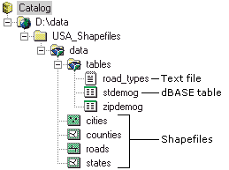
Shapefiles are a simple, nontopological format for storing the geometric location and attribute information of geographic features. Geographic features in a shapefile can be represented by points, lines, or polygons (areas). The workspace may also contain dBASE tables, which can store additional attributes that can be joined to a shapefile's features.
Below is an example of how shapefiles will appear in ArcCatalog. You can also see the dBASE file (that may be associated with a shapefile).
View a table comparing the shapefile and geodatabase feature class
All files that have the file extensions .txt, .asc, .csv, or .tab appear in ArcCatalog as text files by default. However, on the Options dialog box, you can choose which of these file types should be represented as text files and which should not be shown in the Catalog tree. When text files contain comma- and tab-delimited values, you can see their contents in the ArcCatalog table view and join them to geographic features. Text files can be deleted, but their contents are read-only in ArcCatalog.
You can join attributes stored in a dBASE table or text file to the features in a shapefile in a layer's Properties dialog box on the Joins & Relates tab. If a table contains information describing spatial locations, such as x,y,z coordinates or street addresses, you can create a shapefile representing those locations with tools available in ArcCatalog.
In addition to shapefiles and tables, ArcView users work with project files, legend files, and Avenue scripts. While you can't work directly with these items in ArcGIS, you can manage them using ArcCatalog. To see these items in ArcCatalog, you must add their file extensions to the file types list. For example, to see ArcView projects, add the file extension .apr to the list.
Learn about adding file types.
Editing with shapefiles
You can edit shapefiles in ArcGIS with any license level (ArcView, ArcEditor, or ArcInfo). However, to take advantage of advanced editing functionality, such as topology, you will need to import the shapefile into a geodatabase as a feature class.
Learn more about editing in ArcGIS.
Importing shapefiles and dBASE tables to geodatabase feature classes and tables
All feature types in shapefiles convert to geometry types in the geodatabase. Unlike coverages, shapefile feature types are similar to the geometry types stored in a geodatabase, so conversion is more straightforward. For more information, see How data converts when importing.
Shapefile file size limitations
Each of the component files of a shapefile is limited to 2 GB each. Therefore, the .dbf cannot exceed 2 GB, and the .shp cannot exceed 2 GB (these are the only files that are likely to be huge). The total size for all the component files can exceed 2 GB.