Mapping and visualization > Page layout and map composition > Working with data frames in layout view
Using extent rectangles |
|
|
Release 9.3
Last modified April 24, 2009 |


Print all topics in : "Working with data frames in layout view" |
About extent rectangles
Note:
This topic was updated for 9.3.1.
Extent rectangles are a way to show the extent of one data frame within another data frame. This is useful when you are creating inset and overview or reference maps. When you have more than one data frame in a map, you can specify which one should show the extent of any of the other data frames.
Extent rectangles are dynamic in that you can change the extent of either data frame and the extent rectangle will update automatically. Extent rectangles also update when the data is rotated or when the projection is changed.
The top graphic below shows an extent rectangle. The bottom image shows a detailed data frame view.
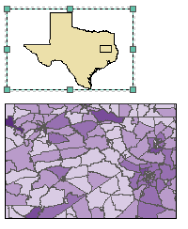
If you just saw the purple map at the bottom, you probably wouldn't know that it is representing the mideastern part of Texas. By adding an overview map of Texas that has an extent rectangle, you'll have a better idea about the location of the bottom map's features.
You need to have two data frames in a map to add an extent rectangle, then you will open the Data Frame Properties for the data frame that will be receiving the extent rectangle.
How to use extent rectangles
- Create a map with two or more data frames where at least one data frame is showing an extent that is completely within the extent of the other.
- Right-click the data frame that will be receiving the extent rectangle in the table of contents and click Properties.
- Click the Extent Rectangles tab.
- Click the data frame with the smaller extent in the Other data frames box.
- Click the > button to add it to the Show extent rectangle for these data frames list.
- To format the extent rectangle, click it in the Show list and click the Frame button.
- Click OK on all dialog boxes.
| Tips |
|