To get the full functional benefits of overlaying caches in the Java Web Application Developer Framework (ADF), you must use ArcGIS Server 9.2, Service Pack 2. Previous 9.2 releases support overlaying caches with dynamic data, but Service Pack 2 contains the software enhancements necessary to overlay two or more cached services.
When you create caches that will overlay each other in the Java Web ADF, the following items require attention:
Coordinate system of your map
Your cached map services must use the same coordinate system to achieve a successful overlay.
Tile origin and tile size
The tile origin represents the upper left corner of the geographic extent covered by the cache tiles. When building any cache that will be viewed through the Java Web ADF, you should avoid placing the tile origin at any point inside the Full Extent of the map. Placing the tile origin on the upper left corner of the Full Extent is appropriate.
When entering the parameters for the map cache, avoid changing the tile origin that appears by default. This value is retrieved automatically from the upper-left corner of the full extent of the map document. If you want to change the tile origin, the recommended workflow is to do the following:
- In ArcMap, open the map document containing the data frame to be cached.
- Right-click the data frame to be cached and click Properties.
- Click the Data Frame tab.
- Under "Extent Used by Full Extent Command", click Other, then click the Specify Extent button.
- Click Current Visible Extent and click OK twice to dismiss the dialogs.
- Save the map document and close ArcMap.
- Using ArcCatalog or Manager, stop and then start the service to be cached.
When overlaying caches in the Java Web ADF, the tile origins of the caches are not required to match. The tile sizes can also differ between caches.
Scale levels
When you add any cached service to your map, your map becomes visible only at the scale levels of that cached service. When you add two or more cached services to your map, the map becomes visible at all of scale levels in all of the cached services. However, the caches will only overlay at the scale levels they have in common.
To provide a smooth navigation experience for the users of your web applications, ensure that the scale levels in your caches match whenever possible. Failure to sequentially match the scales of the caches could result layers not being visible at expected scales. For example, in the diagram below, Cache A was not created at scale level 3, therefore when the user zooms to Scale 3, only Cache B will be visible. Similarly, at scale level 5 Cache A will not be available, but since it is common behavior for a layer to become unavailable at a minimum or maximum scale, this may not present the same problem as the gap at scale level 3.
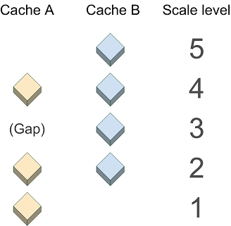
Image format
When selecting an image format for your caches that will be viewed in the Java Web ADF, keep in mind the following points:
- Although the JPG format displays faster than other formats, it does not support transparency. Therefore, only use the JPG image format for a cache when you are certain that it will always be the bottom layer in the map.
- PNG 24-based caches do not show transparency in Internet Explorer 6. (See the related Microsoft technical article at http://support.microsoft.com/kb/294714). If you use a PNG 24-based cache, it will obscure any layers beneath it. A recommended solution is to create the overlaying cache in PNG 8 format.