To get the full functional benefits of overlaying caches in the .NET Web Application Developer Framework (ADF), you must use ArcGIS Server 9.2, Service Pack 2. Previous 9.2 releases support overlaying caches with dynamic data, but Service Pack 2 contains the software enhancements necessary to overlay two or more cached services.
When you create any cache that will be overlaid with another cache in the .NET Web ADF, the following items require attention:
Coordinate system of your map
You will achieve the fastest performance when your cached maps are in the same coordinate system. If you use different coordinate systems, only the cache of the Primary Map Resource is used and the server generates a dynamic image for all other services in the map, thereby forfeiting the performance benefit of those caches.
Tile origin and tile size
When overlaying map caches using the .NET Web ADF, the caches must have the same tile origin and tile size.
Scale levels
You will achieve the performance benefit of both caches only when the two caches have matching scale levels. In the case of a scale level gap (when a scale level exists in one cache but not another), the overlaying image cannot be pulled from the cache and must be generated dynamically, thereby slowing performance. Image quality will also be degraded in this scenario because the dynamic image must be resampled from one of the existing scale levels.
In the diagram below, Cache A does not exist at Scale 3, therefore the .NET Web ADF will generate a dynamic image to overlay the image from Cache B at this scale.
Dynamic images are not created to match scales beyond the top or bottom scale of the cache. Therefore, for Cache A, a dynamic image will not be generated at Scale 5. Instead, Cache A will not be visible at Scale 5; only the cached image from Cache B will be displayed. Similarly, at Scale 1, only Cache A will be visible.
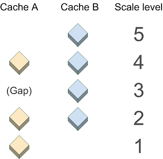
Image format
When selecting an image format for your caches that will be viewed in the .NET Web ADF, keep in mind the following points:
- Although JPG image format tends to display the fastest, it does not support transparency. Therefore, only use the JPG image format for a cache when you are certain that it will always be the bottom layer in the map.
- PNG 24-based caches do not show transparency in Internet Explorer 6. (See the related Microsoft technical article at http://support.microsoft.com/kb/294714). If you use a PNG 24-based cache on top of another cache, the .NET Web ADF automatically converts the top PNG 24 image to a PNG 8, potentially slowing performance. A faster solution is to create the overlaying cache in PNG 8 format.
Setting the Primary Map Resource in your Web application
In .NET Web applications containing more than one map service, the Primary Map Resource determines which service will supply the coordinate system and zoom levels of the map. When you build a Web application in Manager, there is a dropdown labeled "Use coordinate system and extent of:". The service you select here becomes the Primary Map Resource. If you use Visual Studio to build your Web applications, the Primary Map Resource is a property of the Map control. Follow these guidelines for setting the Primary Map Resource:
- If you are overlaying multiple cached services with the same coordinate system, tile origin, tile size, and DPI, select either cached service as the primary map resource. In this scenario, the Zoom Level control will include the scale levels from all cached services.
- If you are overlaying multiple cached services with different coordinate systems, tile origins, tile sizes, or DPIs, select as the Primary Map Resource the service whose coordinate system, tile origin, tile size, and DPI you want used in the map. The Zoom Level control will only include the scale levels from this service.
- If you are overlaying a cached service with a non-cached service, you should generally select the cached service as the Primary Map Resource. The only exception to this would occur if you want the coordinate system of your non-cached service to be used in the map and you are willing to sacrifice the performance benefit of the cache.