All geodatabases store geometry (hence the geo in geodatabase). Each DBMS product used for ArcSDE geodatabases provides specific geometry storage mechanisms. For DB2 DBMSs, geometry is stored using the Spatial Extender. In Informix DBMSs, geometry is stored using the Spatial DataBlade. Oracle, SQL Server, and PostgreSQL DBMSs allow you to choose from different geometry storage options.
For SQL Server databases, you can use either ArcSDE Compressed Binary (the default); the Open Geospatial Consortium, Inc. (OGC), Well-Known Binary (WKB) storage method; or Microsoft's geometry or geography spatial types. For Oracle databases, you can use either ArcSDE Compressed Binary, OGC Well-Known Binary, the spatial type for Oracle, or Oracle Spatial. For PostgreSQL, you can use the spatial type for PostgreSQL or the PostGIS geometry type.
You can see a summary of the geometry storage types in the topic
About geometry storage types.
The configuration keywords associated with each of these storage types are as follows:
| Configuration keyword |
Geometry storage |
|---|
| WKB_GEOMETRY |
OGC Well-Known Binary type |
| SDELOB |
ArcSDE Compressed Binary stored as a binary large object (BLOB) |
| SDEBINARY |
ArcSDE Compressed Binary |
| ST_GEOMETRY |
Spatial type for Oracle or PostgreSQL |
| SDO_GEOMETRY |
Oracle Spatial (including GeoRaster) |
| PG_GEOMETRY |
PostGIS geometry type |
| GEOMETRY |
Microsoft geometry type |
| GEOGRAPHY |
Microsoft geography type |
The ArcSDE administrator will have set the DEFAULTS geometry storage to the type you will use for most datasets. You might specify a different geometry storage configuration keyword and, therefore, use a different geometry storage type for data in the following situations:
- You are using either SQL Server or Oracle; you are only storing simple features, such as points, lines, and polygons, that will not participate in topology, a network, or relationship classes; and you don't need to have ArcSDE compression.
For feature classes that fit this description, you could specify the WKB_GEOMETRY configuration keyword to store the data in OGC Well-Known Binary format.
- You are using an Oracle database, you want to use LOB storage, the total size of the data plus the storage locator is less than 4,000 bytes, and the Oracle ENABLE STORAGE IN ROW clause is specified.
If your data and database settings meet these qualifications, you might want to specify the SDELOB configuration keyword. Note that you can use SDELOB if the total size exceeds 4,000 bytes and/or the DISABLE STORAGE IN ROW clause is specified; however, query performance for that data will be negatively affected.
- You are using Oracle; you want to access the feature class's attributes using Structured Query Language (SQL); and you are only storing simple features, such as points, lines, and polygons, that do not participate in topology, a network, or relationship classes.
For feature classes that fit this description, you could specify the ST_GEOMETRY configuration keyword to store the data in the spatial type for Oracle.
- You have Oracle Spatial or Oracle Locator enabled but you only want to store some of your feature classes in SDO_GEOMETRY format and some of your raster datasets in SDO_GEORASTER.
In this case, you could specify the SDO_GEOMETRY configuration keyword when creating feature classes or raster datasets that meet these criteria.
- You have installed PostGIS but you only want to store some of your feature classes in PostGIS geometry storage. In this case, you could specify the PG_GEOMETRY configuration keyword when creating feature classes you want to store in the PostGIS geometry type.
- You're doing a prototype for your geodatabase and you want to test the relative performance of each storage type for a particular dataset.
When you are designing your geodatabase, you may want to try different storage types to see which ones fit your needs for particular datasets. In that case, you could store the same dataset (with a different name) using different geometry storage configuration keywords, then systematically test the performance of each dataset.
Network configuration keywords are used when you create networks.
Network configuration keywords are composite configuration keywords—three separate network keywords that work together to store tables from the same network class in different places. The network keywords present by default are
NETWORK_DEFAULTS
NETWORK_DEFAULTS::DESC
NETWORK_DEFAULTS::NETWORK
Learn more about composite configuration keywords.
If you do not specify a configuration keyword for your network, the NETWORK_DEFAULTS keywords are used to define the storage for your network.
If you want to create a network class, the components of which you want to store using values different from the default values, create your own set of network keywords. For example, if you are going to create a network for your bus routes that you expect to be much larger than the networks for your rivers and railroads, the ArcSDE administrator could create a set of network configuration keywords to store the bus routes network in a different location in your geodatabase. The ArcSDE administrator could create keywords with the following names:
NETWORK_BUS
NETWORK_BUS::DESC
NETWORK_BUS::NETWORK
For each of these keywords, the administrator could specify config_string values different from those in the NETWORK_DEFAULTS keywords.
If NETWORK_DEFAULTS has
| Keyword |
Parameter_name |
Cconfig_string |
|---|
| NETWORK_DEFAULTS |
A_STORAGE |
PCTFREE 0 INITRANS 4 TABLESPACE CITY |
| NETWORK_DEFAULTS |
D_STORAGE |
PCTFREE 0 INITRANS 4 TABLESPACE CITY |
NETWORK_BUS could have
| Keyword |
Parameter_name |
Config_string |
|---|
| NETWORK_BUS |
A_STORAGE |
PCTFREE 0 INITRANS 4 TABLESPACE BUS |
| NETWORK_BUS |
D_STORAGE |
PCTFREE 0 INITRANS 4 TABLESPACE BUS |
If NETWORK_DEFAULTS::DESC is set this way
| Keyword |
Parameter_name |
Config_string |
|---|
| NETWORK_DEFAULTS::DESC |
A_STORAGE |
PCTFREE 0 INITRANS 4 TABLESPACE CITY |
| NETWORK_DEFAULTS::DESC |
D_STORAGE |
PCTFREE 0 INITRANS 4 TABLESPACE CITY |
NETWORK_BUS::DESC could have these settings
| Keyword |
Parameter_name |
Config_string |
|---|
| NETWORK_BUS::DEFAULTS |
A_STORAGE |
PCTFREE 0 INITRANS 4 TABLESPACE BUS |
| NETWORK_BUS::DEFAULTS |
D_STORAGE |
PCTFREE 0 INITRANS 4 TABLESPACE BUS |
Finally, if NETWORK_DEFAULTS::NETWORK had these parameter values
| Keyword |
Parameter_name |
Config_string |
|---|
| NETWORK_DEFAULTS::NETWORK |
A_STORAGE |
PCTFREE 0 INITRANS 4 TABLESPACE CITY |
| NETWORK_DEFAULTS::NETWORK |
D_STORAGE |
PCTFREE 0 INITRANS 4 TABLESPACE CITY |
NETWORK_BUS::NETWORK could have these parameter values
| keyword |
parameter_name |
config_string |
|---|
| NETWORK_BUS::NETWORK |
A_STORAGE |
PCTFREE 0 INITRANS 4 TABLESPACE BUS |
| NETWORK_BUS::NETWORK |
D_STORAGE |
PCTFREE 0 INITRANS 4 TABLESPACE BUS |
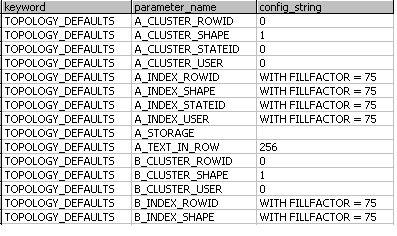
Whenever you create a topology, a topology configuration keyword is used to control the storage of the topology tables.
Topology configuration keywords are composite keywords. The default TOPOLOGY composite keywords are
TOPOLOGY_DEFAULTS
TOPOLOGY_DEFAULTS::DIRTYAREAS
TOPOLOGY_DEFAULTS::DIRTYAREAS designates storage for the DIRTYAREAS topology table.
Learn more about composite configuration keywords.
Learn more about topology.
If you do not choose a different topology keyword when you create a topology, the TOPOLOGY_DEFAULTS and TOPOLOGY_DEFAULTS::DIRTYAREAS keywords are used to designate the storage of your topology tables.
To use a topology keyword other than the default, the ArcSDE administrator creates new topology keywords that designate different storage parameters from those in the defaults.
This process is described in the following example:
- You are using ArcSDE for Oracle.
- The majority of your data is stored using ArcSDE Compressed Binary (SDELOB) in the table space MAIN. All topologies created on this data are also stored in table space MAIN. Some of the parameter values for TOPOLOGY_DEFAULTS are as follows:
| Keyword |
Parameter_name |
Config_string |
|---|
| TOPOLOGY_DEFAULTS |
B_INDEX_ROWID |
PCTFREE 0 INITRANS 4 TABLESPACE MAIN STORAGE (INITIAL 409600) NOLOGGING |
| TOPOLOGY_DEFAULTS |
B_INDEX_SHAPE |
PCTFREE 0 INITRANS 4 TABLESPACE MAIN STORAGE (INITIAL 409600) NOLOGGING |
| TOPOLOGY_DEFAULTS |
B_INDEX_USER |
PCTFREE 0 INITRANS 4 TABLESPACE MAIN STORAGE (INITIAL 409600) NOLOGGING |
| TOPOLOGY_DEFAULTS |
B_STORAGE |
PCTFREE 0 INITRANS 4 TABLESPACE MAIN STORAGE (INITIAL 409600) |
- Some of your data is stored in the Oracle Spatial format (SDO_GEOMETRY) and in the table space SDO.
- All your data that participates in the same topology uses the same geometry storage type, as recommended.
- Since all your SDO_GEOMETRY data is stored in the table space SDO, you want the topology tables used with the SDO data to also be stored in the SDO table space.
- You ask the ArcSDE administrator to create custom topology keywords to designate this storage. The ArcSDE administrator creates and configures these keywords:
TOPOLOGY_SDO
TOPOLOGY_SDO::DIRTYAREAS
Some of the parameter values for TOPOLOGY_SDO are as follows:
| Keyword |
Parameter_name |
Config_sring |
|---|
| TOPOLOGY_SDO |
B_INDEX_ROWID |
PCTFREE 0 INITRANS 4 TABLESPACE SDO STORAGE (INITIAL 409600) NOLOGGING |
| TOPOLOGY_SDO |
B_INDEX_SHAPE |
PCTFREE 0 INITRANS 4 TABLESPACE SDO STORAGE (INITIAL 409600) NOLOGGING |
| TOPOLOGY_SDO |
B_INDEX_USER |
PCTFREE 0 INITRANS 4 TABLESPACE SDO STORAGE (INITIAL 409600) NOLOGGING |
| TOPOLOGY_SDO |
B_STORAGE |
PCTFREE 0 INITRANS 4 TABLESPACE SDO STORAGE (INITIAL 409600) |
When you create topologies for your SDO_GEOMETRY data, specify the TOPOLOGY_SDO configuration keyword, thus storing all your topology tables in the SDO table space.