A type of spatial relationship in which two or more polygons share a side or boundary.
The state or quality of lying close or contiguous.
A representation of a three-dimensional, real-world object in a map or scene, with elevation values (z-values) stored within the feature's geometry. Besides geometry, 3D features may have attributes stored in a feature table. In applications such as CAD, 3D features are often referred to as 3D models.
A representation of a three-dimensional, real-world object in a map or scene, with elevation values (z-values) stored within the feature's geometry. Unlike 3D features, 3D graphics do not have attributes.
In Survey Analyst for field measurements, one of two possibilities for performing a constrained adjustment. In the absolutely constrained adjustment, the coordinates of the reference points keep their original value. Use this method when reference points should remain unchanged in the survey dataset.
In ArcObjects, a specification for subclasses that is often shown on object model diagrams to help give structure to the diagram. An abstract class is not defined in a type library and cannot be instantiated.
A keyboard shortcut that allows a user to access the contents of the Main menu by holding down the Alt key and pressing the underlined letter on the menu or menu command item. An access key is created by placing an ampersand (&) in front of the appropriate letter in the command's caption.
The degree to which a measured value conforms to true or accepted values. Accuracy is a measure of correctness. It is distinguished from precision, which measures exactness.
See also precision, uncertainty.In ArcGIS, an XML file that contains an acknowledgement message.
See also acknowledgement message.In ArcGIS, a message from a replica to its relative acknowledging the data changes received by the sending replica.
See also replica, relative replica.The data frame currently being worked on—for example, the data frame to which layers are being added. The active data frame is highlighted on the map, and its name is shown in bold text in the table of contents.
In Survey Analyst for field measurements, the focus of the analyses applied. In an active network, users may list a network's datum points in the Survey Explorer, detect and solve breaks in the network's computation sequence, and find and repair cycles in the network.
A designation of the location of a person's residence or workplace, an organization, or a building, consisting of numerical and text elements such as a street number, street name, and city arranged in a particular format.
Data that contains address information used for geocoding. Address data may consist of one individual address or a table containing many addresses.
See also geocoding.The arrangement of address information in a database, most often consisting of such address elements as house number, street direction, street name, street type, city, and postal code.
The rules of a geodatabase designed specifically to accommodate address-related material, such as streets, zones, ranges, and so forth. These rules define the address elements, their attribute values, and the relationships between them. An address data model facilitates address data storage.
One of the components that comprise an address. House numbers, street names, street types, and street directions are examples of address elements.
In ArcGIS, features that can be located based on address matching with a street network or other address identifier, such as ZIP Codes or lot numbers.
See also event, address event table, address matching.In ArcGIS, a table containing addresses but no spatial reference information. Using GIS software, address event tables can be geocoded to create a spatial data layer.
See also address style.A column in a table that stores one or some address elements. An address field can be present in reference data, address data, or both.
The particular structure and arrangement of address elements and a corresponding method of matching that can be used for a specific application. The address format may vary based on locale or country.
A dataset in ArcGIS that stores the address attributes, associated indexes, and rules that define the process for translating nonspatial descriptions of places, such as street addresses, into spatial data that can be displayed as features on a map. An address locator contains a snapshot of the reference data used for geocoding, and parameters for standardizing addresses, searching for match locations, and creating output. Address locator files have a .loc file extension. In ArcGIS 8.3 and previous versions, an address locator was called a geocoding service.
A parameter in an address locator that defines the process of geocoding.
A template on which an address locator is built. Each template is designed to accommodate a specific format of address and reference data, and geocoding parameters. The address locator style template file has a .lot file extension.
A process that compares an address or a table of addresses to the address attributes of a reference dataset to determine whether a particular address falls within an address range associated with a feature in the reference dataset. If an address falls within a feature's address range, it is considered a match and a location can be returned.
Street numbers running from lowest to highest along a street or street segment. Address ranges are generally stored as fields in the attribute table of a street data layer. They often indicate ranges on the left and right sides of streets.
The process of breaking down an address into elements and converting those elements with standard abbreviations or spellings. For best practices, this process applies to preparing the reference data and address data for matching.
See also address standardizer.A tool that prepares and breaks down an address into elements that can be used for geocoding. The process may translate some elements into standard keywords or abbreviations; for example, "Avenue" may be translated to "Ave."
A set of guidelines that define the format of addresses and methods of matching that can be used for a specific application.
See also address event table, geocoding.The geodatabase system table, created when a feature class or table is registered as versioned, that maintains information on all rows that have been inserted or updated.
See also delta table.A type of spatial relationship in which two or more polygons share a side or boundary.
The state or quality of lying close or contiguous.
A statement or logical expression used to select geographic features that share a boundary.
In Survey Analyst for cadastres, a number that corresponds to a specific set of displacement vectors in a series of adjustments to the cadastral fabric. The adjustment level is generally identified by the date and time of the adjustment.
See also displacement vector.A photograph of the earth's surface taken from a platform flying above the surface but not in orbit, usually an aircraft. Aerial photography is often used as a cartographic data source for basemapping, locating geographic features, and interpreting environmental conditions.
See also orthophotograph.In MOLE, the type of threat posed by the war fighting element being represented. The four basic types supported by MOLE are unknown, friend, neutral, and hostile.
See also war fighting element.A geometric transformation that scales, rotates, skews, and/or translates images or coordinates between any two Euclidean spaces. It is commonly used in GIS to transform maps between coordinate systems. In an affine transformation, parallel lines remain parallel, the midpoint of a line segment remains a midpoint, and all points on a straight line remain on a straight line.
See also transformation.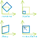
Acronym for Aeronautical Information Exchange Format. An XML format used to describe aeronautical data transactions created and maintained by EUROCONTROL (European Organisation for the Safety of Air Navigation), in the process of being adopted worldwide.
An alternative name specified for fields, tables, files, or datasets that is more descriptive and user-friendly than the actual name. On computer networks, a single e-mail alias may refer to a group of e-mail addresses.
In geoprocessing, an alternate name for a toolbox. Toolbox aliases can be used to avoid confusion when working with tools with the same name that are stored in different toolboxes. For example, tools in the Analysis Tools toolbox can be differentiated from similar tools in the Spatial Analyst Tools toolbox by adding "_analysis" to their names at the command line, as in "clip_analysis."
The jagged appearance of curves and diagonal lines in a raster image. Aliasing becomes more apparent as the size of the raster pixels is increased or the resolution of the image is decreased.
A drafting symbol that runs parallel to the baseline and indicates the true distance between beginning and ending dimension points.
See also linear dimension.A name for an address element, usually a street name, that is different from the official or most common name. For example, a highway number might be an alternate name for a street name.
See also alias.The height or vertical elevation of a point above a reference surface. Altitude measurements are usually based on a given reference datum, such as mean sea level.
The height above the horizon, measured in degrees, from which a light source illuminates a surface. Altitude is used when calculating a hillshade, or for controlling the position of a light source in a scene.
Acronym for ARC Macro Language. A proprietary, high-level programming language created by ESRI for generating end-user applications in ArcInfo Workstation.
A systematic examination of a problem or complex entity in order to provide new information from what is already known.
The geographic bounding area within which spatial analysis will occur. The bounding area is set by defining the x,y coordinates of opposite corners, usually the bottom-left and top-right corners of results.
In digital image processing, data from sources other than remote sensing, used to assist in analysis and classification or to populate metadata.
Supplementary data.
A supplementary source of information.
The unit of measurement on a sphere or a spheroid, usually degrees. Some map projection parameters, such as the central meridian and standard parallel, are defined in angular units.
See also linear unit.In ArcMap, ArcScene, and ArcGlobe, a collection of animation tracks that define the dynamic property changes to associated objects. An animation allows for navigation through the display, visualization of temporal changes, or alteration of layer and scene properties, such as layer transparency or the scene background.
In ArcMap, ArcScene, and ArcGlobe, the interface in which the keyframes, tracks and time-scale properties of an animation can be edited and an animation can be timed and previewed.
A property of a spatial process or data in which spatial dependence (autocorrelation) changes with both the distance and the direction between two locations.
See also isotropy, autocorrelation.In ArcGIS, text or graphics that can be individually selected, positioned, and modified. Annotation may be manually entered or generated from labels. Annotation can be stored as features in a geodatabase or as map annotation in a data frame.
See also label, annotation class, graphic text, text formatting tag, feature-linked annotation, map annotation.A subset of annotation in a standard or feature-linked geodatabase annotation feature class that contains properties that determine how the subset of annotation will display. A standard or feature-linked geodatabase annotation feature class may contain one or more annotation classes.
One of a number of procedures that dictate what type of annotation feature is created and the number of points required to create new annotation features. Construction methods include horizontal, straight, curved, leader line, and follow feature.
A geodatabase feature class that stores text or graphics that provide information about features or general areas of a map (annotation). An annotation feature class may be linked to another feature class, so that edits to the features are reflected in the corresponding annotation (feature-linked annotation). Annotation in a geodatabase is edited during an edit session, using the tools on the Annotation toolbar.
See also annotation group.A container within a map document for organizing and managing text or graphics that provide additional information about features or general areas of a map. Annotation groups allow control of the display of different sets of annotation. Annotation stored in a map document is edited with the tools on the Drawing toolbar.
See also annotation feature class.A layer that references annotation. Information stored for annotation includes a text string, a position at which it can be displayed, and display characteristics.
See also layer.In ArcMap, the annotation group or feature class in a map document where new annotation will be stored when created when using the New Text tools on the Draw toolbar or when copying and pasting annotation. Annotation created with the Annotation Edit tools is stored in the current Editing target, not in the annotation target.
In network datasets, a type of edge connectivity policy that states that an edge may connect to another edge or junction where they have coincident vertices.
See also endpoint connectivity, edge connectivity policy.Acronym for application programming interface. A set of interfaces, methods, protocols, and tools that application developers use to build or customize a software program. APIs make it easier to develop a program by providing building blocks of prewritten, tested, and documented code that are incorporated into the new program. APIs can be built for any programming language.
A military symbology specification published by NATO (North Atlantic Treaty Organization). APP-6A is based on MIL-STD-2525A, the predecessor to MIL-STD-2525B.
Adding features from multiple data sources of the same data type into an existing dataset.
See also merging.A computer program used for a specific task or purpose, such as accounting or GIS.
A computer program that receives user requests through a client application and returns results to the client.
On a map, a shape defined by a connected series of unique x,y coordinate pairs. An arc may be straight or curved.
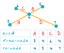
A coverage feature class that represents lines and polygon boundaries. One line feature can contain many arcs. Arcs are topologically linked to nodes and to polygons. Their attributes are stored in an arc attribute table (AAT). Nodes indicate the endpoints and intersections of arcs; they do not exist as independent features. Together, the from-node and the to-node define the direction of the arc.
A Web-based system for sharing, finding, and using maps, layers, and services. ArcGIS Online includes a set of base maps, map layers, and tools published by ESRI for use inside ArcGIS products.
An ArcGIS extension that provides spatial modeling and analysis features. It allows the creation, querying, mapping, and analysis of cell-based raster data and integrated vector-raster analysis.
The internal design of an application or software package; the way software or hardware components are organized into a functioning unit.
In ArcGIS and ArcSDE, a procedure that allows a geodatabase to capture and store updates to features and records as the version is posted or edits are saved directly. Archiving builds a lineage of historical information that can be viewed and queried.
ESRI software that allows for centrally hosting and serving GIS maps, data, and applications for use on the Internet. The administrative framework lets users author configuration files, publish maps, design Web pages, and administer ArcIMS spatial servers. ArcIMS supports Windows, Linux, and UNIX platforms and is customizable on many levels.
A file format, also known as an export file, used to enable a coverage, grid or TIN and an associated INFO table to be transferred between different machines which are not connected by any type of file sharing network. ArcInfo interchange files have a .E00 extension, which increments to .E01, .E02, and so on, if the interchange file is composed of several separate files.
A file-based collection of coverages, grids, TINs, or shapefiles stored as a directory of folders in the file system.
See also workspace.The data structure in a coverage used to represent linear features and polygon boundaries and to support analysis functions, such as network tracing. Nodes represent the beginning and ending vertices of each arc. Arcs that share a node are connected, and polygons are defined by a series of connected arcs. An arc that intersects another arc is split into two arcs. Each arc that defines all or part of a polygon boundary records the number of the polygon to its left and to its right, giving it a direction of travel.
Technology for managing geographic information in a relational database management system (RDBMS). ArcSDE is part of the ArcGIS platform, and is the data server between ArcGIS and relational databases. It is widely used to enable geographic information to be shared by many users across a network and to scale in size from personal, to workgroup, to enterprise use.
The user who administers ArcSDE geodatabases. The ArcSDE administrative user can be the SDE user, but for DBO-schema ArcSDE geodatabases in SQL Server it is any user whose login is mapped to DBO in the database, and for user-schema geodatabases in Oracle, the ArcSDE administrative user is the user in whose schema the geodatabase is stored.
See also SDE user.In ArcCatalog, an instance of SQL Server Express used to store ArcSDE geodatabases.
A geodatabase stored in an RDBMS served to client applications using ArcSDE technology. An ArcSDE geodatabase can support long transactions and versioned workflows, be used as a workspace for geoprocessing tasks, and provide the benefits of a relational database such as security, scalability, backup and recovery, and SQL access.
A single-user ArcSDE geodatabase that is created on Microsoft SQL Server Express.
See also single-user geodatabase.A user interface in ArcGIS used for accessing, organizing, and managing a collection of geoprocessing tools, models, and scripts.
A dockable window used to display, manage, and use the contents of toolboxes in ArcGIS. It provides a shortcut to frequently used tools contained within toolboxes that may be stored in folders or geodatabases on disk.
In ArcView 3, a file for creating and storing documents for GIS work. All activity in ArcView 3 takes place within project files, which use five types of documents to organize information: views, tables, charts, layouts, and Avenue scripts. A project file organizes its documents and stores their unique settings in an ASCII format file with the extension .apr.
A closed, two-dimensional shape defined by its boundary or by a contiguous set of raster cells.
A calculation of the size of a two-dimensional feature, measured in square units.
In Survey Analyst - Cadastral Editor, a continuous set of parcels that have been selected for adjustment by least-squares.
See also least-squares adjustment.The extent used to define a focus area for either a map or database production.
A number, variable, function, or combination of these, with operators or parentheses, or both, that can be evaluated to produce a single number.
See also expression.A type of mathematical function that performs a calculation on the values of cells in an input raster. There are six arithmetic functions in ArcGIS Spatial Analyst: Abs, Int, Float, Round up (Ceil), Round down (Floor) and Negate.
Acronym for American Standard Code for Information Interchange. The de facto standard for the format of text files in computers and on the Internet that assigns a 7-bit binary number to each alphanumeric or special character. ASCII defines 128 possible characters.
The compass direction that a topographic slope faces, usually measured in degrees from north. Aspect can be generated from continuous elevation surfaces. For example, the aspect recorded for a TIN face is the steepest downslope direction of the face, and the aspect of a cell in a raster is the steepest downslope direction of a plane defined by the cell and its eight surrounding neighbors.
The conceptual center of a projection system.
A type of operator that assigns the result of an expression to an output, usually a raster, for storage.
In Survey Analyst - Cadastral Editor, a feature class that uses the cadastral fabric as a basemap, and has been associated with cadastral fabric. Associated feature classes can be corrected to maintain alignment with cadastral fabric parcels after least-squares adjustments of the cadastral fabric.
See also cadastral fabric.Not synchronous; that is, not occurring together or at the same time.
A measure of the combined attributes of a center or site that are considered positive features or that draw in potential customers or tenants.
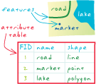
See also gravity model.Nonspatial information about a geographic feature in a GIS, usually stored in a table and linked to the feature by a unique identifier. For example, attributes of a river might include its name, length, and sediment load at a gauging station.
In raster datasets, information associated with each unique value of a raster cell.
Information that specifies how features are displayed and labeled on a map; for example, the graphic attributes of a river might include line thickness, line length, color, and font for labeling.
In MOLE, aspatial information about a geographic feature in a GIS, usually stored in a table and linked to the feature by a unique identifier. For example, attributes of a force element might include its name and speed. Most MOLE attributes are what some military specifications refer to as labels or modifiers.
Tabular or textual data describing the geographic characteristics of features.
In a geodatabase, a mechanism for enforcing data integrity. Attribute domains define what values are allowed in a field in a feature class or nonspatial attribute table. If the features or nonspatial objects have been grouped into subtypes, different attribute domains can be assigned to each of the subtypes.
See also domain, coded value domain, spatial domain, range domain.A request for records of features in a table based on their attribute values.
See also attribute.In ArcMap, a dialog box that displays attributes of selected features for editing.
A database or tabular file containing information about a set of geographic features, usually arranged so that each row represents a feature and each column represents one feature attribute. In raster datasets, each row of an attribute table corresponds to a certain zone of cells having the same value. In a GIS, attribute tables are often joined or related to spatial data layers, and the attribute values they contain can be used to find, query, and symbolize features or raster cells.
The process of validating the identity of a user who logs on to a computer system, network, or Web site.
The correlation or similarity of values, generally values that are nearby in a dataset. Temporal data is said to exhibit serial autocorrelation when values measured close together in time are more similar than values measured far apart in time. Spatial data is said to exhibit spatial autocorrelation when values measured nearby in space are more similar than values measured farther away from each other.
See also correlation, spatial autocorrelation.The automatic functioning of a machine, system, or process, without the need for human interaction.
In COM technology, a feature that allows an object that was designed for use in one application to be accessed in another application. For example, ArcObjects may be accessed in Visual Basic and in other languages, tools, and applications that support automation.
The object-oriented programming language on which ArcView 3.x is based. Avenue provides tools for customizing ArcView 3.x and developing ArcView 3.x applications.
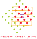
The average distance separating sample points in a point dataset. A terrain dataset uses the average point spacing of a dataset to define a horizontal tiling system into which to divide input source measurements.
The horizontal angle, measured in degrees, between a baseline drawn from a center point and another line drawn from the same point. Normally, the baseline points true north and the angle is measured clockwise from the baseline.
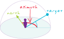
A compass direction. For example, in some GIS software, the direction from which a light source illuminates a surface is called the azimuth.
In navigation, the horizontal angle, measured in degrees, between a reference line drawn from a point and another line drawn from the same point to a point on the celestial sphere. Normally, the reference line points true north and the angle is measured clockwise from the reference line.
A map projection that transforms points from a spheroid or sphere onto a tangent or secant plane. The azimuthal projection is also known as a planar or zenithal projection.
A copy of a file, a set of files, or a disk for safekeeping in case the original is lost or damaged.
A set of adjacent wavelengths or frequencies with a common characteristic. For example, visible light is one band of the electromagnetic spectrum, which also includes radio, gamma, and infrared waves.
See also raster dataset band.
In network analysis, an entity that prevents flow from traversing a network edge or junction.
A line feature used to keep certain points from being used in the calculation of new values when a raster is interpolated. The line can represent a cliff, ridge, or some other interruption in the landscape. Only the sample points on the same side of the barrier as the current processing cell will be considered.
For geometric networks in ArcMap, a temporary graphic that is placed on the network, past which a trace cannot continue.
For network datasets in ArcMap, a network location in a network analysis layer that restricts the traversability of a network element (edge or junction) in the network dataset.
In ArcGIS 3D Analyst, the height at which a surface, raster, or feature is drawn in a scene. Base height for features and rasters can be set from a surface, such as a DEM, or by using a constant value or expression. Features with z-values stored in their geometry can have their base height set using the z-values. Setting the base heights from a surface is also called draping.
In ArcGIS Tracking Analyst, the default symbol used to represent an event or a feature on a map.
The process of geocoding many address records at the same time.
A method for processing data automatically in which the data is grouped into batches and executed by the computer at one time, without user interaction.
An automated process that converts raster data into vector features for an entire raster or a portion of it based on user-defined settings.
See also vectorization.In MOLE, the primary area in which a force unit operates, such as air, space, ground, sea, surface, and subsurface.
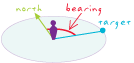
See also force element.The horizontal direction of a point in relation to another point, expressed as an angle from a known direction, usually north, and usually measured from 0 degrees at the reference direction clockwise through 360 degrees. Bearings are often referred to as true bearings, magnetic bearings, or assumed bearings, depending on whether the meridian is true, magnetic, or assumed.
In Survey Analyst for field measurements, one of two methods for computing the coordinate geometry traverse. The bearing method uses compass directions for the orientation of each course.
The actions or characteristics exhibited by an object in a database, as defined by a set of rules.
The route of least impedance between two or more locations, taking into account connectivity and travel restrictions such as one-way streets and rush-hour traffic.
A curved line whose shape is derived mathematically rather than by a series of connected vertices. In graphics programs, a Bézier curve usually has two endpoints and two handles that can be moved to change the direction and the steepness of the curve. Bézier curves are named for the French engineer Pierre Bézier (1910-1999).

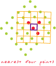
A resampling method that uses a weighted average of the four nearest cells to determine a new cell value.
A method for displaying graphics associated with features in a three-dimensional map display by posting them vertically as two-dimensional symbols and orienting them to always face the user.
In a variogram map, each cell that groups lags with similar distance and direction. Bins are commonly formed by dividing the sample area into a grid of cells or sectors, and are used to calculate the empirical semivariogram for kriging.
In a histogram, user-defined size classes for a variable.
The smallest unit of information within a computer. A bit can have one of two values, 1 and 0, that can represent on and off, yes and no, or true and false.
The range of values that a particular raster format can store. Each bit depth determines the number of values that the format can store, which is based on the formula 2^n. An 8-bit depth dataset can store 256 unique values.
Acronym for binary large object. A large block of data, such as an image, a sound file, or geometry, stored in a database. The database cannot read the BLOB's structure and only references it by its size and location.
The data type of the column in the database that stores binary large objects.
In ArcGIS, a group of records in a compressed file geodatabase feature class or table that are stored together. The arrangement of compressed data into blocks helps optimize query performance.
See also file geodatabase.A unit of U.S. census geography that is a combination of census blocks. A block group is the smallest unit for which the U.S. Census Bureau reports a full range of demographic statistics. There are about 700 residents per block group. A block group is a subdivision of a census tract.
In surveying, a defective measurement that can be detected by a statistical test.
An expression, named for the English mathematician George Boole (1815-1864), that results in a true or false (logical) condition. For example, in the Boolean expression "HEIGHT > 70 AND DIAMETER = 100," all locations where the height is greater than 70 and the diameter is equal to 100 would be given a value of 1, or true, and all locations where this criteria is not met would be given a value of 0, or false.
See also expression.A logical operator used in the formulation of a Boolean expression. Common Boolean operators include AND, which specifies a combination of conditions (A and B must be true); OR, which specifies a list of alternative conditions (A or B must be true); NOT, which negates a condition (A but not B must be true); and XOR (exclusive or), which makes conditions mutually exclusive (A or B may be true but not both A and B).
See also operator, Boolean expression.A problem created during spatial analysis, caused by arbitrary or discrete boundaries being imposed on spatial data representing nondiscrete or unbounded spatial phenomena. Boundary problems include edge effects, in which patterns of interaction or interdependency across the borders of the bounded region are ignored or distorted, and shape effects, in which the shape imposed on the bounded area affects the perceived interactions between phenomena.
In Survey Analyst - Cadastral Editor, an irregular mesh of parcel boundaries, connection lines and control points representing a cadastral fabric. A boundary network represents parcels implicitly joined together, and is used by least-squares adjustment to distribute error from fixed control points based on the precision of boundary dimensions (bearings and distances).
See also cadastral fabric.In ArcGIS Network Analyst, an object used in vehicle routing problem (VRP) analysis. A break can be used to model a specified period of rest along a route within a vehicle routing problem VRP instance.
A line in a TIN that represents a distinct interruption in the slope of a surface, such as a ridge, road, or stream. No triangle in a TIN may cross a breakline (in other words, breaklines are enforced as triangle edges). Z-values along a breakline can be constant or variable.
See also structure line.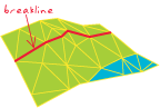
A zone around a map feature measured in units of distance or time. A buffer is useful for proximity analysis.
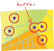
A polygon enclosing a point, line, or polygon at a specified distance.
Space on a computer disk or RAM that has been allocated for temporary storage. This temporary storage may also be called a spooler when it is used to hold data in memory before the data is sent to another machine, such as a printer.
In ArcGIS, the process of creating a network system. For geometric networks, this includes establishing connectivity, creating network features, and creating logical network tables. For network datasets, this includes establishing connectivity, creating network elements, and assigning network attribute values.
An ArcInfo Workstation command that constructs topology and creates a feature attribute table for a coverage.
An ArcToolbox command in the Coverage toolbox that creates or updates feature attribute tables and polygon topology. Build is also used to synchronize polygon User-IDs with label point User-IDs.
In Survey Analyst - Cadastral Editor, a cadastral fabric editing command that creates a parcel from construction lines and legal records.
See also construction line, unbuild parcel.In a geodatabase, the spatially-enabled DBMS table that holds the main attribute values of a dataset. A business table with a spatial column is a feature class, and a business table with a raster column is a raster dataset or a raster catalog. In the database, the business table name is the dataset name.
A command that executes a function, macro, or custom code when clicked.
In defense, an abbreviation used to signify that a computer program or system supports command, control, communication, computers, and information.
Acronym for computer-aided design. A computer-based system for the design, drafting, and display of graphical information. Also known as computer-aided drafting, such systems are most commonly used to support engineering, planning, and illustrating activities.
In Survey Analyst - Cadastral Editor, a network of connected parcels. Parcels are represented by parcel line features, parcel point features, and parcel polygon features, referred to in aggregate as parcel features. Parcel topology in the cadastral fabric is stored explicitly through shared or common parcel point features.
See also current cadastral fabric, default cadastral fabric.In Survey Analyst - Cadastral Editor, a number assigned to a parcel line that determines how much the line influences the coordinates that result from a least-squares adjustment. A line with a high accuracy level will have more influence than a line with a lower accuracy level. The highest accuracy level in the cadastral fabric is 1.
See also cadastral fabric parcel line.In Survey Analyst - Cadastral Editor, the record of changes to the legal and system state of the cadastral fabric.
See also cadastral fabric.In Survey Analyst - Cadastral Editor, a collection of parcels that have been extracted from the cadastral fabric for editing and least-squares adjustment. Parcels in the cadastral fabric are always edited in cadastral fabric jobs.
In Survey Analyst - Cadastral Editor, the map representation of a cadastral fabric for which display properties may be set; a layer in ArcMap that represents the cadastral fabric.
See also cadastral fabric.In Survey Analyst - Cadastral Editor, a point that allows a parcel corner to lie on an adjacent parcel boundary line without splitting the boundary line. Line points are constrained to lie on their parcel lines.
See also cadastral fabric parcel line.In Survey Analyst - Cadastral Editor, a parcel line feature in the cadastral fabric that contains dimension information. Represents parcel boundaries. Parcel lines connect up to form parcel polygons and always connect two point features in the cadastral fabric.
In Survey Analyst - Cadastral Editor, a line type that defines how a parcel line in the cadastral fabric will be managed by the cadastral fabric editor. For example, connection lines are managed differently than boundary lines.
See also cadastral fabric parcel line.In Survey Analyst - Cadastral Editor, a point represents a parcel corner or the end of a connection line. A parcel point always has computed x- and y-coordinates.
In Survey Analyst - Cadastral Editor, an internal feature class that forms part of the cadastral fabric. Cadastral Fabric sublayers include lines, points, polygons, line points, and control points.
In Survey Analyst - Cadastral Editor, the topological relationships explicit in the cadastral fabric data model.
See also topology.A boundary survey taken for the purposes of ownership and taxation.
See also cadastre.An official record of the dimensions and value of land parcels, used to record ownership and assist in calculating taxes.
The digital equivalent of a drawing, figure, or schematic created using a CAD system.
In ArcCatalog, an item in the Catalog tree representing all features and annotation in a CAD file. The symbology defined in the CAD file determines how features are drawn in ArcMap or in the ArcCatalog preview.
The pictorial representation of an entire CAD file that can be viewed in any ArcGIS application with a display. The CAD drawing dataset is a vector data source of a mixed feature type in which the symbology is set to mimic that of the originating CAD application. The graphic properties of a CAD drawing dataset's objects can be identified, but the dataset is not usable for feature class-based queries or analysis.
A read-only member of a CAD feature dataset, comprised of one of the following: polylines, points, polygons, multipatch, or annotation. The feature attribute table of a CAD feature class is a virtual table comprised of select CAD graphic properties and any existing field attribute values.
The feature representation of a CAD file in a geodatabase-enforced schema. A CAD feature dataset is comprised of five read-only feature classes: points, polylines, polygons, multipatch and annotation. ArcGIS supported formats include DWG (AutoCAD), DXF (AutoDesk Drawing Exchange Format), and DGN (the default Microstation file format).
The digital equivalent of a drawing, figure, or schematic created using a CAD system. CAD files are the data source for CAD drawing datasets, feature datasets and feature classes. ArcGIS software-supported formats include DWG (AutoCAD), DXF (AutoDesk Drawing Exchange Format), and DGN (the default Microstation file format). A CAD file is represented in ArcCatalog with a CAD feature dataset and a CAD drawing dataset.
A layer that references a set of CAD data. CAD data is vector data of a mixed feature type. CAD layers may be of two types: CAD drawing dataset layers, in which one map layer represents the entire CAD file, and CAD feature layers, in which data is organized by geometry type.
A component of a CAD drawing file. CAD layers are the digital equivalent of acetates in overlay drafting, and are powerful tools for organizing a drawing into logical categories. CAD layers and levels may be managed with ArcGIS. In MicroStation, layers are also referred to as levels.
A normalized, fixed set of feature classes and data tables of a predefined schema from a collection of input CAD drawings.
The comparison of the accuracy of an instrument's measurements to a known standard.
In spatial analysis, the selection of attribute values and computational parameters that will cause a model to properly represent the situation being analyzed. For example, in pathfinding and allocation, calibration generally refers to assigning or calculating impedance values.
A line on a map extending between a feature's geographic position and its corresponding symbol or label, used in areas where there is not enough room to display a symbol or label in its correct location.
In ArcScene and ArcGlobe, an object that defines the perspective of a scene or globe's display.
A record returned as a potential match for an address in the geocoding process.
In ArcGIS, the text for a command that appears with the "Text Only" and "Image and Text" display types. As part of the user interface, captions are customizable by the user.
The correspondence or equivalency between sets; how sets relate to each other. For example, if one row in a table is related to three rows in another table, the cardinality is one to many.
A two-dimensional, planar coordinate system in which horizontal distance is measured along an x-axis and vertical distance is measured along a y-axis. Each point on the plane is defined by an x,y coordinate. Relative measures of distance, area, and direction are constant throughout the Cartesian coordinate plane. The Cartesian coordinate system is named for the French mathematician and philosopher René Descartes (1596-1650).
See also coordinate system.
One who practices the art and science of expressing graphically, usually through maps, the natural and social features of the earth.
The art and science of expressing graphically, usually through maps, the natural and social features of the earth.
Acronym for computer-aided software engineering. Any software that assists with the development and maintenance of software, especially the analysis and design. Complex tasks that often require many lines of code are simplified with CASE user interfaces and code generators.
In ArcCatalog, a hierarchical view of folder connections which provide access to GIS data stored on local disks or shared on a network that allows users to manage connections to databases and GIS servers.
An optical disk, slightly less than 5 inches in diameter, used to store up to approximately 650 megabytes of data.
The smallest unit of information in raster data, usually square in shape. In a map or GIS dataset, each cell represents a portion of the earth, such as a square meter or square mile, and usually has an attribute value associated with it, such as soil type or vegetation class.
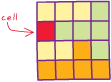
A pixel.
A small drawing, usually of a frequently used or complex symbol, notation, or detail. Cells are similar to blocks in AutoCAD drawings.
The process of selecting raster cells either interactively or by using a SQL query.
The dimensions on the ground of a single cell in a raster, measured in map units. Cell size is often used synonymously with pixel size.
An ArcGIS Spatial Analyst function that calculates a statistic for each cell of an output raster that is based on the values of each cell in the same location of multiple input rasters.
Any one of various types of precisely defined geographic areas used by the U.S. Census Bureau to collect and aggregate data. The largest unit of area is the entire United States, while the smallest is a census block.
A small, statistical subdivision of a county that usually includes approximately 4,000 inhabitants but may include from 2,500 to 8,000 inhabitants. A census tract is designed to encompass a population with relatively uniform economic status, living conditions, and some demographic characteristics. Tract boundaries normally follow physical features but may also follow administrative boundaries or other nonphysical features. A census tract is a combination of census block groups.
See also block group.A line digitized along the center of a linear geographic feature, such as a street or a river, that at a large enough scale would be represented by a polygon.
The generation of vector features along the center of connected cells. It is typically used for vectorizing scanned parcel and survey maps.
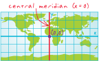
The line of longitude that defines the center and often the x-origin of a projected coordinate system. In planar rectangular coordinate systems of limited extent, such as state plane, grid north coincides with true north at the central meridian.
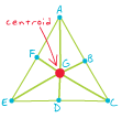
The geometric center of a feature. Of a line, it is the midpoint; of a polygon, the center of area; of a three-dimensional figure, the center of volume.
A map used to plot a course for air or water navigation.
A graphic representation of tabular data; a diagram showing the relationship between two or more variable quantities, usually measured along two perpendicular axes. A chart may also be referred to as a graph.
In disconnected editing, the procedure that transfers a copy of data into a master geodatabase, overwriting the original copy of that data and reenabling it so it can be accessed and saved from that location. In checkout/check-in replication, check-in is the procedure that synchronizes the data in the parent replica with that in the child replica.
A procedure in disconnected editing that records the duplication of data from one geodatabase to another and disables the original data so that both versions cannot be accessed or saved at the same time.
A type of geodatabase replication that involves copying data to a destination geodatabase, editing that data in the destination, and then merging the changes with the source geodatabase. In ArcGIS and ArcSDE, the destination can be a file, personal, or ArcSDE geodatabase, while the source must be an ArcSDE geodatabase. Once the data is merged (synchronized), checkout/check-in replication is completed.
See also replication.The data version created in a checkout geodatabase when data is checked out to that database during disconnected editing. The checkout version is created as a copy of the synchronization version. Only the edits made to this checkout version can be checked back in to the master geodatabase.
In geodatabase editing, data that has been copied to a destination geodatabase during the replication process.
See also replica.A thematic map in which areas are distinctly colored or shaded to represent classed values of a particular phenomenon.
See also thematic map.Acronym for Chart Updating Manual. A document containing updates to aeronautical information, used by the U.S. military to update their current published products with the latest information.
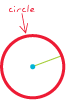
A two-dimensional geometric shape for which the distance from the center to any point on the edge is equal; the closed curve defining such a shape.
A curved line that is a section of a circle, with two vertices, one situated at each endpoint.

A measure of directional variation, on a scale from zero to one, among a set of line vectors. Circular variance approaches zero when all vectors point in roughly the same direction and approaches one when the vectors point in markedly different directions.
See also vector.A set of entities grouped together on the basis of shared attribute values.
Pixels in a raster file that represent the same condition.
The process of sorting or arranging entities into groups or categories; on a map, the process of representing members of a group by the same symbol, usually defined in a legend.
See also equal-area classification, equal-interval classification, natural breaks classification, quantile classification, standard deviation classification.An application, computer, or device in a client/server model that makes requests to a server.
An address locator that is created and used on the same computer.
A command that extracts features from one feature class that reside entirely within a boundary defined by features in another feature class.
In surveying, a traverse that starts and ends with the same survey point.
In ArcGIS Network Analyst, a type of network analysis for finding the closest locations (facilities) from sites (incidents), based on the impedance chosen—for example, finding hospitals near a car accident. When finding closest facilities, users can specify how many to find and whether the direction of travel is toward or away from the site (incident). Users can also specify a cutoff threshold beyond which ArcGIS Network Analyst will not search for a facility—for example, finding hospitals within 6 miles of a car accident.
A discrepancy between existing coordinates and computed coordinates that occurs when the final point of a closed traverse has known coordinates and the final course of a traverse computes different coordinates for the same survey point.
The summary of the difference between the endpoint coordinate of a traverse and the calculated endpoint.
A part of the topology validation process in which vertices that fall within a specified distance (cluster tolerance) of each other are snapped together.
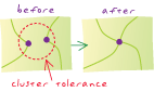
The minimum tolerated distance between vertices in a topology. Vertices that fall within the set cluster tolerance are snapped together during the topology validation process.
A type of attribute domain that defines a set of permissible values for an attribute in a geodatabase. A coded value domain consists of a code and its equivalent value. For example, for a road feature class, the numbers 1, 2, and 3 might correspond to three types of road surface: gravel, asphalt, and concrete. Codes are stored in a geodatabase, and corresponding values appear in an attribute table.
Acronym for coordinate geometry. A method for calculating coordinate points from surveyed bearings, distances, and angles.
Automated mapping software used in land surveying that calculates locations using distances and bearings from known reference points.
In Survey Analyst for field measurements, measurements that comprise a set of interdependent COGO simple measurements.
In Survey Analyst for field measurements, measurements that model values that define vectors, directions, lengths, and orthogonal offsets.
Occupying the same space. Coincident features or parts of features occupy the same space in the same plane.
A set of values that are associated with specific colors. Color maps are most commonly used to display a raster dataset consistently on many different platforms.
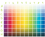
A range of colors used to show ranking or order among classes on a map.
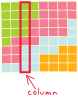
An item in an attribute table.
The vertical dimension of a table. Each column stores the values of one type of attribute for all the records, or rows, in the table. All the values in a given column are of the same data type; for example, number, string, BLOB, or date.
A vertical group of cells in a raster, or pixels in an image.
A kind of mathematical operator that interprets input with Boolean values. Combinatorial operators assign a different number to each unique combination of input values.
A user interface tool that combines the features of a text box and a drop-down list. For example, the Location combo box in ArcCatalog allows the selection of an item in the Catalog tree by typing its path or choosing its path from a drop-down list.
An instruction to a computer program, usually one word or concatenated words or letters, given by the user from a control device, such as a keyboard, or read from a file by a command interpreter.
A menu, menu item, button, combo box, text box, or tool on a toolbar.
Any class in an ArcGIS system that implements the ICommand interface and can, therefore, be added to a menu or toolbar in an ArcGIS application.
A string of text that acts as a command, typed at an interface prompt.
A format of the input and output of a program in which the user enters commands by means of strings of text typed on a keyboard, as opposed to selecting commands from graphical prompts such as icons or dialog boxes.
In geoprocessing, a window that provides a command line for running tools and a message window for viewing the status messages created when running those tools.
In Survey Analyst for field measurements, a field that provides additional information about the computation.
One or more specially marked lines of text used to document the code in a script or program. Comments are ignored when the code is run.
The isolation level in a database management system (DBMS) in which transactions read committed data only — they don't read data that has not been committed.
See also isolation level, serializable read, uncommitted read.A process that rearranges and consolidates the data in a file so that it occupies a single, contiguous space, allowing the data in each file to be accessed more efficiently.
A widely used rule for adjusting a traverse that assumes the precision in angles or directions is equivalent to the precision in distances. This rule distributes the closure error over the whole traverse by changing the northings and eastings of each traverse point in proportion to the distance from the beginning of the traverse. More specifically, a correction factor is computed for each point as the sum of the distances along the traverse from the first point to the point in question, divided by the total length of the traverse. The correction factor at each point is multiplied by the overall closure error to get the amount of error correction distributed to the point's coordinates. The compass rule is also known as the Bowditch rule, named for the American mathematician and navigator Nathaniel Bowditch (1773-1838).
In ArcMap and Survey Analyst for field measurements, one of three adjustment methods available for adjusting closure error for a traverse computation. The other two methods are the transit rule and the Crandall rule.
In ArcGIS Tracking Analyst, a type of complex temporal event that includes two components and involves a moving object, such as an airplane. The moving object's geographical location changes through time, so its additional attributes are stored in an input table.
In a geodatabase, a linear network feature that corresponds to one or more network elements in the logical network.
An area calculated by finding the outermost customers of a store along several vectors and connecting them. Complex market areas are more accurate than simple market areas because they respond to physical and cultural barriers. They are sometimes called amoebas because of their irregular shapes.
See also simple market area.A type of complex temporal event in ArcGIS Tracking Analyst that includes two components and involves a stationary object, such as a traffic sensor. The sensor's geographical location will not change, so its location information is stored in the input feature class.
An event in ArcGIS Tracking Analyst that contains two components: one with persistent object information, and one with observations of the object through time. The merger of the temporal observations with the temporal object creates a complex event record or message. There are two types of complex temporal events: dynamic and stationary.
In Survey Analyst for field measurement, a set of simple measurements that are related and applied as a group.
A link or association between objects where the lifetime of one object controls the lifetime of its related objects. For example, the association between a highway and its shield markers is a composite relationship, since the shield markers should not exist without the highway.
See also simple relationship.Within metadata, a group of data elements (including other compound elements) that together describe a characteristic of a spatial dataset in more detail than can be described by an individual data element.
A primary key that requires two or more fields to be unique.
See also key.The process of reducing the size of a file or database. Compression improves data handling, storage, and database performance. Examples of compression methods include quadtrees, run-length encoding, and wavelets.
A process that removes unreferenced rows from geodatabase system tables and user delta tables. Compression helps maintain versioned geodatabase performance.
In Survey Analyst for field measurements, a process that requires a set of input parameters to apply a set of rules, and an algorithm to calculate output parameters. The input parameters are typically coordinates and measurements. The output parameters are usually coordinates.
In Survey Analyst for field measurements, a unique identifier that calls or retrieves a specific type of computation, defined on the General tab of the Survey Explorer.
In Survey Analyst for field measurements, a sequence of computation dependencies—the output points of some computations are used as the input for one or more others.
In Survey Analyst for field measurements, a window that displays information about the computation network, such as breaks in the sequence, computation states, and computation network cycles.
In Survey Analyst for field measurements, a problem that occurs when a point's coordinates are used as both input and output within the same computation network. Cycles must be fixed before the whole network can be validated and brought to a state in which all computations are valid.
In Survey Analyst for field measurements, the condition of a computation. A computation may be in four different states: valid, out-of-date, incorrect, or incomplete.
In Survey Analyst for field measurements, a tool that interacts with the map to add measurement values to computation pages.
To join two or more character strings together, end to end; for example, to combine the two strings "spatial" and "analysis" into the single string "spatial analysis."
In linear referencing, a command that combines event records in tables containing events on the same route with the same value for specified fields. Only events in situations where the to-measure of one event matches the from-measure of the next event are combined. The concatenate events command is available for line event tables only.
The ability of a DBMS to support simultaneous access by more than one user.
A database management process for maintaining the consistency of data while supporting simultaneous editing by more than one user. A typical technique involves locking portions of the database to prevent data corruption caused by multiple users simultaneously editing data.
A component of the PLTS knowledge base that contains SQL statements and custom code for feature validation extended beyond standard geodatabase domains. PLTS utilizes condition tables for enhanced validation during both database production and quality control.
See also knowledge base.In a statistical test, the risk, expressed as a percentage, that the null hypothesis will be incorrectly rejected because of sampling error when the null hypothesis is true. For example, a confidence level of 95 percent means that if the same test were performed 100 times on 100 different samples, the null hypothesis would be incorrectly rejected five times.
See also significance level.In database editing, a state of incompatibility that occurs when multiple users simultaneously edit a version or reconcile two versions. Conflicts occur when the same feature or topologically related features are edited in two versions, and it is unclear which representation of the database is valid.
The process of solving uncertainty within a database that occurs when two versions of the same data are edited at the same time. Conflicts can occur when multiple users simultaneously edit the same feature or topologically related features, or reconcile two versions of a dataset. Resolving a conflict requires that the user make a decision about the feature's correct representation and identify it in the Conflict Resolution dialog box.
A projection that preserves the correct shapes of small areas. In a conformal projection, graticule lines intersect at 90-degree angles, and at any point on the map the scale is the same in all directions. A conformal projection maintains all angles at each point, including those between the intersections of arcs; therefore, the size of areas enclosed by many arcs may be greatly distorted. No map projection can preserve the shapes of larger regions.
A projection that transforms points from a spheroid or sphere onto a tangent or secant cone that is wrapped around the globe in the manner of a party hat. The cone is then sliced from the apex (top) to the bottom, and flattened into a plane.
In ArcCatalog, a mechanism used to access remote file systems and shared databases.
A cadastral fabric line with bearing and distance data attached to it, commonly used to tie parcels across roads, tie in control points, or tie the point of survey commencement to the point of beginning for a particular parcel. Connection lines do not necessarily indicate parcel boundaries.
See also cadastral fabric, cadastral fabric parcel line.The way in which features in GIS data are attached to one another functionally or spatially.
In a geodatabase, the state of association between edges and junctions in a network system for network data models. Connectivity helps define and control flow, tracing, and pathfinding in a network.
In a coverage, topological identification of connected arcs by recording the from-node and to-node for each arc. Arcs that share a common node are connected.
In network datasets, a logical grouping of point features, line features, or both, that controls how network elements are connected. Connectivity groups are defined when a network dataset is built. A network dataset may have multiple connectivity groups.
See also connectivity.In a network dataset, a property of network sources that defines how network elements connect to each other within a connectivity group. There are two types of edge-edge connectivity policies (end-point connectivity and any-vertex connectivity) and two types of edge-junction connectivity policies (honor and override).
See also connectivity rule, connectivity group, endpoint connectivity, any-vertex connectivity, honor, override.
In geometric networks, a rule that constrains the type and number of network features that can be connected to one another. There are two types of connectivity rules: edge-edge and edge-junction.

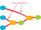
A visual representation of the relationship between elements in a model. Connectors join elements together to create processes. Typical processes connect an input data element, a tool element, and a derived data element.
In Survey Analyst for field measurements, one of two phases involved when performing a least squares adjustment for a measurement network. In this phase, the emphasis is on testing the reference points as well as computing final coordinates.
Limits imposed on a model to maintain data integrity. For example, in a water network model, an 8-inch pipe cannot connect to a 4-inch pipe.
In ArcMap, an edit command that takes selected features from one or more feature classes and creates new features in a target feature class. The Construct Features tool uses the input geometries of the selected features to construct polygons or lines following polygon boundaries, depending on the geometry of the target feature class.
In Survey Analyst - Cadastral Editor, a line with a bearing and distance that is used to create geometry for a new cadastral fabric parcel.
A spatial relationship in which a point, line, or polygon feature or set of features is enclosed completely within a polygon.
In ArcGIS Online, refers to maps, layers, and tools.
See also item.A publication authored by the FGDC that specifies the information content of metadata for digital geospatial datasets. The purpose of the standard is to provide a common set of terminology and definitions for concepts related to the metadata. All U.S. government agencies (federal, state, and local) that receive federal funds to create metadata must follow this standard.
In a coverage, the topological identification of adjacent polygons by recording the left and right polygon for each arc.
See also polygon-arc topology.A feature that is not spatially discrete. The transition between possible values on a continuous surface is without abrupt or well-defined breaks.
See also discrete feature.A raster in which cell values vary continuously to form a surface. In a continuous raster, the phenomena represented have no clear boundaries. Values exist on a scale relative to each other. It is assumed that the value assigned to each cell is what is found at the center of the cell. Rasters representing elevation, precipitation, chemical concentrations, suitability models, or distance from a road are examples of continuous rasters.
A line on a map that connects points of equal elevation based on a vertical datum, usually sea level.
An accurately surveyed coordinate location for a physical feature that can be identified on the ground. Control points are used in least-squares adjustments as the basis for improving the spatial accuracy of all other points to which they are connected.
In statistical testing, a set of assumptions that will be accepted by test data if the null hypothesis is rejected. In surveying, the alternative hypothesis assumes that there is an outlier present in a single measurement in a measurement network. The test associated with this hypothesis is the W-test.
The process of changing input data from one representation or format to another, such as from raster to vector, or from one file format to another, such as from x,y coordinate table to point shapefile.
The smallest convex polygon that encloses a group of objects, such as points. In ArcGIS, TIN boundaries are convex hulls by default.
In Survey Analyst, a process of computing a sequence of survey point locations starting from an initial known point. Each new survey point is defined by a traverse course and is used as the takeoff point for the next point in the sequence. A traverse course can be defined using various combinations of directions, distances, angles, and circular arc parameters. The coordinate geometry traverse is primarily used to define coordinates based on values taken from subdivision plans.
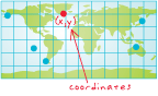
A set of values represented by the letters x, y, and optionally z or m (measure), that define a position within a spatial reference. Coordinates are used to represent locations in space relative to other locations.
A reference framework consisting of a set of points, lines, and/or surfaces, and a set of rules, used to define the positions of points in space in either two or three dimensions. The Cartesian coordinate system and the geographic coordinate system used on the earth's surface are common examples of coordinate systems.

In ArcGIS, a reference system that locates a position in space and defines the relationships between positions. Coordinate systems enable individual datasets to be georeferenced to each other. The specification of a coordinate system is one of the initial steps in creating a new feature class or raster dataset. Three coordinate systems commonly used in ArcGIS include geographic, projected, and vertical.
An association between data or variables that change or occur together. For example, a positive correlation exists between housing costs and distance from the beach; generally, the closer a home is to the beach, the more it costs. Correlation does not imply causation. For example, there is a statistical correlation between ice cream sales and crime rates, but neither causes the other. The correlation coefficient is an index number between -1 and 1 indicating the strength of the association between two variables.
A function of time, distance, or any other factor that incurs difficulty or an outlay of resources.
In ArcGIS Network Analyst, an attribute of a network element used to model impedance and demand in network datasets. Cost is an attribute that is accumulated during traversal of a network.
The calculation of the least cumulative cost from each cell to specified source locations over a cost raster.
See also cost raster.A raster dataset that identifies the cost of traveling through each cell in the raster. A cost raster can be used to calculate the cumulative cost of traveling from every cell in the raster to a source or a set of sources.
See also cost.An ArcGIS Spatial Analyst function that identifies the nearest source from each cell in a cost-weighted distance grid. Each cell is assigned to its nearest source cell, in terms of accumulated travel cost.
An ArcGIS Spatial Analyst function that provides a road map from the cost weighted distance grid, identifying the route to take from any cell, along the least-cost path, back to the nearest source.
An ArcGIS Spatial Analyst function that uses a cost grid to assign a value—the least accumulative cost of getting back to the source—to each cell of an output grid.
A data model for storing geographic features. A coverage stores a set of thematically associated data considered to be a unit. It usually represents a single layer, such as soils, streams, roads, or land use. In a coverage, features are stored as both primary features (points, arcs, polygons) and secondary features (tics, links, annotation). Feature attributes are described and stored independently in feature attribute tables. Coverages cannot be edited in ArcGIS 8.3 and subsequent versions.
In ArcInfo, a classification describing the format of geographic features and supporting data in a coverage. Feature classes include point, arc, node, route, route system, section, polygon, and region. One or more coverage features are used to model geographic features; for example, arcs and nodes can be used to model linear features, such as street centerlines. The tic, annotation, link, and boundary feature classes provide supporting data for coverage data management and viewing.
The units of the coordinate system in which a coverage is stored (for example, feet, meters, inches).
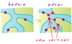
In ArcGIS, a part of the topology validation process in which vertices are created at the intersection of feature edges.
A special-case, least-squares-based method for adjusting the closure error in a traverse. The Crandall rule is most frequently used in a closed traverse that represents a parcel from a subdivision plan to ensure that tangency between courses remains intact as, for example, when applied to a tangent curve. It assumes that course directions and angles have no error and, therefore, all error corrections are applied only to the distances. This method uses a least-squares adjustment to distribute the closure error, and applies infinite weight to the angles or direction measurements to ensure that they are not adjusted. In some circumstances the results of this adjustment method may be unexpected, or the adjustment may not be possible, and an alternative method is required. The Crandall rule was developed by C.L. Crandall around 1901.
In ArcMap and Survey Analyst for field measurements, one of three adjustment methods available for adjusting closure error for a traverse computation. The other two methods are the transit rule and the compass rule.
In Survey Analyst for field measurements, an attribute of the computation that records the date of origin.
The specific cutoff point that determines acceptance or rejection of a hypothesis. Critical values are determined by the choice of a level of significance (α).
Marks that indicate the edge of the page of a finished, printed map. Cropmarks are used as a reference for trimming excess paper after printing.
Statistical correlation between spatial random variables of different types, attributes, names, and so on, where the correlation depends on the distance or direction that separates the locations.
See also autocorrelation.The statistical tendency of variables of different types, attributes, names, and so on, to vary in ways that are related to each other. Positive cross covariance occurs when both variables tend to be above their respective means together, and negative cross covariance occurs if one variable tends to be above its mean when the other variable is below its mean.
A database containing tables with information defining the mapping between a data source schema and an output geodatabase schema. Cross-reference databases are used by the PLTS data loader to batch populate a geodatabase from a variety of sources.
See also PLTS data loader, schema.A procedure for testing the quality of a predicted data distribution. In cross validation, a piece of data whose value is known independently is removed from the dataset and the rest of the data is used to predict its value. Full cross validation is done by removing, in turn, each piece of data from the dataset and using the rest of the data to predict its value.
A function of the distance and direction separating two locations, used to quantify cross correlation. The cross variogram is defined as the variance of the difference between two variables of different types or attributes at two locations. The cross variogram generally increases with distance, and is described by nugget, sill, and range parameters.
Acronym for Cascading Style Sheets. A standard for defining the layout or presentation of an HTML or XML document. Style information includes font size, background color, text alignment, and margins. Multiple style sheets may be applied to "cascade" over previous style settings, adding to or overriding them. The World Wide Web Consortium maintains the CSS standard.
See also style sheet, W3C.A technique for resampling raster data in which the average of the nearest 16 cells is used to calculate the new cell value.
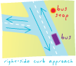
In network analysis, a network location property that models a path for approaching a stop from a specific side based on edge direction. For example, a school bus must approach a school from its door side so that students exiting the bus will not have to cross the street. There are three types of curb approaches: left, right, or both.
In Survey Analyst - Cadastral Editor, the most up-to-date legal state of the cadastral fabric.
See also default cadastral fabric.In Survey Analyst for field measurements, the single coordinate for a survey point that is the best representation for its location within each project. A current coordinate is required when the same project computes or imports more than one coordinate for a particular survey point.
A user-specified path to a container for file-based geographic data, set in the Environment Settings dialog box. Data from the current workspace can be accessed from any tool dialog box (including script and model dialog boxes), or at the command line simply by typing its name.
A set of methods, functions or operations associated with a database object that has been specifically created or overridden by a programmer.
A type of market analysis that focuses on data about customers, rather than about a store or stores. An example is desire line analysis.
See also store market analysis.A process that establishes common demographic characteristics for a set of customers within a geographic area.
A type of market analysis that locates regions with appropriate demographic characteristics for targeting new customers.
In geodatabases, a feature with specialized behavior instantiated in a class by a programmer.
A layer created in ArcMap using the ArcGIS Image Server extension. Custom group layers display the contents of an image service definition, including the footprint, boundary, seamline and preview raster layer.
In geoprocessing, a tool created by a user and added to a toolset and/or toolbox. Custom tools may only be added to custom toolsets and/or toolboxes.
In geoprocessing, a subset of a toolbox created by a user to hold custom tools or a group of frequently used tools.
An ArcGIS Spatial Analyst and 3D Analyst function that summarizes areas and volumes of change between two surfaces.
A projection that transforms points from a spheroid or sphere onto a tangent or secant cylinder. The cylinder is then sliced from top to bottom and flattened into a plane.
See also projection.
The endpoint of a dangling arc.
See also dangling arc.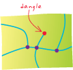
In ArcInfo coverages, the minimum length allowed for dangling arcs by the clean process, which removes dangling arcs shorter than the dangle tolerance.
An arc having the same polygon on both its left and right sides and having at least one node that does not connect to any other arc. It often occurs where a polygon does not close properly, where arcs do not connect properly (an undershoot), or where an arc was digitized past its intersection with another arc (an overshoot). A dangling arc is not always an error; for example, it can represent a cul-de-sac in a street network.
See also undershoot, overshoot.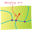
Any collection of related facts arranged in a particular format; often, the basic elements of information that are produced, stored, or processed by a computer.
One or more structured sets of persistent data, managed and stored as a unit and generally associated with software to update and query the data. A simple database might be a single file with many records, each of which references the same set of fields. A GIS database includes data about the spatial locations and shapes of geographic features recorded as points, lines, areas, pixels, grid cells, or TINs, as well as their attributes.
See also geodatabase.The person who manages a database. Database administration includes user setup, security, backup and recovery procedures for data, and optimization of physical data storage for best performance.
A link to a database from a software application. Database connections have two states: connected to or disconnected from the database. Deletion of a database connection only deletes the connection itself, not the database or its contents. Creation of a database connection requires selection of a data provider for data retrieval.
See also database.A set of software applications used to create and maintain databases according to a schema. Database management systems provide tools for adding, storing, changing, deleting, and retrieving data.
See also database.The database permissions category assigned to a group of users who perform the same types of tasks and, therefore, require the same level of database access. Database roles are used by database administrators to simplify the administration of user privileges.
Mathematically calculated data that describes the state of a database and which the database management system (DBMS) uses to optimize query response.
In ArcGIS, a message containing any inserts, updates, and deletes applied to a replica. These messages are used to synchronize replicas in a disconnected environment.
See also replica.A catalog or table containing information about the datasets stored in a database. In a GIS, a data dictionary might contain the full names of attributes, meanings of codes, scale of source data, accuracy of locations, and map projections used.
See also metadata.A type of market analysis primarily used to look at competing sites or to select potential new locations.
The smallest unit of information used to describe a particular characteristic of a spatial dataset. A data element is a logically primitive description that cannot be further subdivided.
See also compound element.A map element that defines a geographic extent, a page extent, a coordinate system, and other display properties for one or more layers in ArcMap. A dataset can be represented in one or more data frames. In data view, only one data frame is displayed at a time; in layout view, all a map's data frames are displayed at the same time. Many cartography texts use the term "map body" to refer to what ESRI calls a data frame.
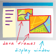
The degree to which the data in a database is accurate and consistent according to data model and data type.
In GIS, a mathematical construct for representing geographic objects or surfaces as data. For example, the vector data model represents geography as collections of points, lines, and polygons; the raster data model represents geography as cell matrixes that store numeric values; and the TIN data model represents geography as sets of contiguous, nonoverlapping triangles.
In ArcGIS, a set of database design specifications for objects in a GIS application. A data model describes the thematic layers used in the application (for example, hamburger stands, roads, and counties); their spatial representation (for example, point, line, or polygon); their attributes; their integrity rules and relationships (for example, counties must nest within states); their cartographic portrayal; and their metadata requirements.
In information theory, a description of the rules by which data is defined, organized, queried, and updated within an information system (usually a database management system).
Any collection of related data, usually grouped or stored together.
The mathematical exactness or detail with which a value is stored within a dataset, based on the number of significant digits that can be stored for each coordinate.
In Survey Analyst, the process of testing each measurement using the W-test.
Any data. Data sources may include coverages, shapefiles, rasters, or feature classes.
The process of applying data changes from a replica to the relative replica in a replica pair. Data changes include row or feature inserts, updates, and deletes. Synchronization can be performed in one or both directions between a replica pair.
See also replica, relative replica.The attribute of a variable, field, or column in a table that determines the kind of data it can store. Common data types include character, integer, decimal, single, double, and string.
An all-purpose view in ArcMap and ArcReader for exploring, displaying, and querying geographic data. This view hides all map elements, such as titles, north arrows, and scale bars.
The reference specifications of a measurement system, usually a system of coordinate positions on a surface (a horizontal datum) or heights above or below a surface (a vertical datum).
See also geocentric datum, geodetic datum.In Survey Analyst for field measurements, survey points that are not defined by computations, but that are the input data for the initial computations in a sequence of computations.
Values of latitude and longitude expressed in decimal format rather than in degrees, minutes, and seconds.
In Survey Analyst - Cadastral Editor, the most up-to-date version of the cadastral fabric in the database that corresponds to the default version in the database. The default cadastral fabric does not represent the current legal state of the cadastral fabric.
See also current cadastral fabric.In geometric networks, the user-established junction type that automatically connects two edges in the absence of a current user choice. An edge may also have a default end junction type, used for the free ends of new edges.
A study area with a defined boundary, such as a city.
In ArcMap, a request that examines feature or tabular attributes based on user-selected criteria and displays only those features or records that satisfy the criteria.
See also query.The creation of a segment at an angle relative to an existing segment.
A unit of angular measure represented by the symbol °. The earth is divided into 360 degrees of longitude and 180 degrees of latitude.
One method for representing the measurement of an inclined surface. The steepness of a slope may be measured from 0 to 90 degrees.
The unit of measure for describing latitude and longitude. A degree is 1/360th of a circle. A degree is further divided into 60 minutes, and a minute is divided into 60 seconds.
A technique for creating a mesh of contiguous, nonoverlapping triangles from a dataset of points. Each triangle's circumscribing circle contains no points from the dataset in its interior. Delaunay triangulation is named for the Russian mathematician Boris Nikolaevich Delaunay.
See also Thiessen polygons.
The geodatabase system table, created when a feature class or table is registered as versioned, that maintains information on all rows that have been deleted or updated.
See also delta table.A file that contains data edits that can be exchanged between geodatabases or between geodatabases and other data stores. The edits can come from a checkout geodatabase, modified rows between source and target versions, or a custom application. Supported delta file formats are XML (delta XML file) and delta database (.mdb file).
One of two geodatabase system tables—the adds and deletes tables—created for a feature class or table when it is registered as versioned. These tables record changes made to a version during editing.
See also adds table, deletes table.Acronym for digital elevation model. The representation of continuous elevation values over a topographic surface by a regular array of z-values, referenced to a common datum. DEMs are typically used to represent terrain relief.
A format for elevation data, tiled by map sheet, produced by the National Mapping Division of the USGS.
The statistical study of human populations, especially their locations, distribution, economic statistics, and vital statistics.
In spatial measurements, the quantity per unit area or length.
In a substance such as a gas, solid, or liquid, a measurement of the ratio of mass to volume.
In ArcGIS Spatial Analyst, a function that distributes the quantity or magnitude of point or line observations over a unit of area to create a continuous raster—for example, population per square kilometer.
The variable representing the process being predicted or modeled, such as crime, foreclosure, or rainfall. The dependent variable is a function of the independent variables. Regression can be used to predict the dependent variable, using known (observed) values to build (calibrate) the regression model. In the regression equation, the dependent variable appears on the left side of the equal sign.
See also independent variable, regression equation.In ArcGIS Network Analyst, a network location used to represent a starting, stopping, or renewal location for routes in vehicle routing problem (VRP) analysis. Users can specify multiple depots. Depots are used as locations for loading/unloading vehicles within the fleet.
In ArcGIS Network Analyst, an object used to represent a single visit to a specific depot in vehicle routing problem (VRP) analysis. A depot visit may occur at the start of a route, the end of the route, or as a renewal midway along a route.
In ModelBuilder, data created by running a geoprocessing operation on existing data. Derived data from one process can serve as input data for another process.
See also input data, project data.A type of attribute for network elements that cannot be apportioned. The value of a descriptor stays the same through the length of an edge element in a network dataset. Descriptors describe characteristics of the element; for example, the number of lanes for a particular road in a road network.
See also network attribute, cost, descriptor, hierarchy.A type of market analysis that draws lines from a set of geocoded points (usually customers) to a single, central point (usually a store). Desire lines can be weighted.
See also weight.Mapping software that is installed onto and runs on a personal computer and allows users to display, query, update, and analyze data about geographic locations and the information linked to those locations.
The secondary object in a relationship class, such as a table containing attributes associated with features in a related table.
In ArcGIS Network Analyst, a network location used in origin-destination cost matrix analysis that specifies an ending location.
In ArcGIS Spatial Analyst, the ending point for a path when finding the least-cost path.
In ArcView 3.x, one of the two tables involved in a join operation. The destination table must be the active table; the attributes of the source (inactive) table are appended to it.
One of two types of pages in the Survey Analyst Survey Explorer. The Detail page displays a detailed view of individual survey objects.
A conclusively definitive line or course in which something is issuing or moving in a stream. For an edge feature, this occurs when the flow direction can be ascertained from the connectivity of a network, the locations of sources and sinks, and the enabled or disabled states of features.
In spatial modeling, a type of model or a part of a model in which the outcome is completely and exactly known based on known input; the fixed or nonrandom components of a spatial model. The spline and inverse distance weighted interpolation methods are deterministic since they have no random components. The kriging and cokriging interpolation methods may have a deterministic component, often called the trend.
See also model, stochastic model, trend.The process of removing the trend from a spatial model by subtracting the trend surface (usually polynomial functions of the spatial x- and y-coordinates) from the original data values. The resulting detrended values are called residuals.
See also trend.In geoprocessing, a form consisting of a tool's parameters.
A technique for increasing the accuracy of GPS measurements by comparing the readings to two receivers—one roving and the other a fixed base station—and a known location.
A device connected to a computer, consisting of a tablet and a handheld puck, that converts positions on the tablet surface as they are traced by an operator to digital x,y coordinates, yielding vector data consisting of points, lines, and polygons.

The title of a person who uses a digitizer.
An optical device that translates an analog image into an array of digital pixel values. A video digitizer can be used in place of a manual digitizer, but since it produces a raster image, additional software must be used to convert the data into vector format before topological analysis can be done.
The process of converting the geographic features on an analog map into digital format using a digitizing tablet, or digitizer, which is connected to a computer. Features on a paper map are traced with a digitizer puck, a device similar to a mouse, and the x,y coordinates of these features are automatically recorded and stored as spatial data.
A way of using a digitizing tablet in which locations on the tablet are mapped to specific locations on the screen. Moving the digitizer puck on the tablet surface causes the screen pointer to move to precisely the same position on the screen.
A length of a certain distance and bearing.
The area over which an entity extends.
The number of axes that are essential to the existence of an entity in space. For example, the identity of a location on a plane requires two axes; therefore, a plane exists in the second dimension, and an entity with two axes, or dimensions, may be uniquely identified as a plane.

One of a number of procedures that dictate what type of dimension feature is created and the number of points required to complete the feature's geometry. Construction methods include simple aligned, aligned, linear, rotated linear, free aligned, and free linear.
In ArcMap, a special kind of geodatabase annotation that shows specific lengths or distances on a map. A dimension feature may indicate the length of a side of a building or land parcel, or it may indicate the distance between two features, such as a fire hydrant and the corner of a building.
A geodatabase feature class that stores dimension features.
A toolbar in ArcMap that facilitates the creation of dimension features.
Description of a dimension feature's symbology, what parts of it are drawn, and how it is drawn. Every time a new dimension feature is created, it is assigned a particular style according to its shared characteristics. A collection of dimension styles is associated with a dimension feature class. Styles for a dimension feature class are created, copied, and managed using ArcCatalog or the editing capabilities in ArcMap. Styles are then assigned to individual dimension features.
An ArcSDE connection that results in a two-tier configuration, in which the ArcSDE client application communicates directly with the database.
A network state in which edges have an associated direction of flow. In a directed network flow, the resource that traverses a network's components cannot choose a direction to take, as in hydrologic and utility systems.
See also undirected network flow, downstream, upstream.
In an ArcGIS vertical coordinate system, an identifier that indicates whether z-values are positive up or positive down. Heights or elevations are usually positive up, against the force of gravity (indicated by +1). Depths are usually positive down, with the force of gravity (indicated by -1).
In Survey Analyst for field measurements, a field in the computation page that allows the entry of bearings or azimuths between an input survey point and a computed survey point.
An area of a computer disk that holds a set of data files, other directories, or both. Operating systems use directories to organize data. Directories are arranged in a tree structure, in which each branch is a subdirectory of its parent branch. The location of a directory is specified with a path—for example, C:\gisprojects\shrinkinglemurhabitatgrids.
Regions surrounding features that have been altered after the initial topology validation process and require additional topology validation to be performed to find any errors.
In geometric networks, an object or shape representing a geographic object through which flow is impossible.
The process of copying data to another geodatabase, editing that data, then merging the changes with the data in the source or master geodatabase.
A method of digitizing in which points are placed individually to define a feature's shape.
See also digitizing, stream mode digitizing.A feature that has definite feature boundaries.
A raster that typically represents phenomena that have clear boundaries with attributes that are descriptions, classes, or categories. Generally, integers are used for the cell values. In a raster of land cover, for example, the value 1 might represent forestland, the value 2 urban land, and so on. It is assumed that the phenomena that each value represents fill the entire area of the cell. Rasters representing land use, political boundaries or ownership are examples of discrete rasters.
A storage medium for recording digital information, consisting of a round, flat, spinning plate coated with a magnetic material.
In ArcGIS, a link created to define the source and destination coordinates for a spatial adjustment. Links are represented as arrows with the arrowhead pointing toward the destination location. Links can be created manually or loaded from a link file.
In Survey Analyst - Cadastral Editor, the difference in the coordinates of a point between successive least-squares adjustments. A set of displacement vectors is recorded for a point when the point is part of a least-squares adjustment. Adjustment vectors can be used to track spatial changes in the cadastral fabric over time, and to adjust associated feature classes to match the most up to date cadastral fabric location.
See also associated feature class.The mode of command representation on a computer screen. The display type controls whether you see a command's image, its caption, or both when it appears on a toolbar or in a menu.
The unit of measure used to render dimensions of shapes, distance tolerances, and offsets on a computer screen or on a printed map. Although they are stored with consistent units in the dataset, users can choose the units in which coordinates and measurements are displayed—for example, feet, miles, meters, or kilometers.
In linear referencing, a procedure that combines event records in tables where there are events on the same route that have the same value for specified fields. The Dissolve Route Events tool combines events when there is measure overlap, and is available for both line and point event tables.
In the Survey Analyst for field measurements Survey Explorer, a field for entering distance for use in a computation.
The unit of measurement for distance, such as feet, miles, meters, and kilometers.
See also unit of measure.Data spread over multiple platforms or a network by a process referred to as replication.
See also replication.Acronym for digital line graph. Data files containing vector representations of cartographic information derived from USGS maps and related sources. DLGs include information from the USGS planimetric map base categories such as transportation, hydrography, contours, and public land survey boundaries.
Acronym for dynamic-link library. A type of file that stores shared code to be used by multiple programs (a "code library"). Programs access the shared code by linking to the DLL file when they run, a process referred to as dynamic linking. The DLL file must be registered for other programs to locate it.
Acronym for digital nautical chart. A nautical database developed from existing hard-copy charts, digital data, bathymetric survey information, imagery, and various raster data. DNCs are used by the U.S. military and its allies for marine navigation.
Moving a floating toolbar or window to a fixed location in the graphical user interface.
A component of an ArcView 3.x project. Each document type (view, table, chart, layout, script) has its own window and interface.
Supporting information for software data and tools. Documentation may be descriptive or instructional, and is published in a variety of formats, including user's guides and manuals, desktop help systems, embedded or context-sensitive help, tutorials, reports, and metadata.
In geoprocessing, the interface used to write documentation for tools, toolsets, toolboxes, and processes within a model.
The range of valid values for a particular metadata element.
See also coded value domain, range domain, attribute domain, spatial domain.A method of defining the rings in an analysis so that the values inside the rings are exclusive. For example, in an analysis with three donut rings and 10 households in each, the total number of households for each ring would be 10.
Acronym for dilution of precision. An indicator of satellite geometry for a constellation of satellites used to determine a position. Positions with a lower DOP value generally constitute better measurement results than those with higher DOP. Factors determining the total GDOP (geometric DOP) for a set of satellites include PDOP (positional DOP), HDOP (horizontal DOP), VDOP (vertical DOP), and TDOP (time DOP).
Acronym for digital orthophoto quarter quadrangle. A digital orthophoto quadrangle (DOQ) divided into four quadrants.
See also orthophotograph.A quantitative, thematic map on which dots of the same size are randomly placed in proportion to a numeric attribute associated with an area. Dot density maps convey the intensity of an attribute.
The level of coordinate exactness based on the possible number of significant digits that can be stored for each coordinate. Datasets can be stored in either single or double precision. Double-precision geometries store up to 15 significant digits per coordinate (typically 13 to 14 significant digits), retaining the accuracy of much less than 1 meter at a global extent.
In network tracing, the direction along a line or edge that is the same as the direction of flow.
See also upstream, directed network flow.A layer in ArcGlobe that has been categorized to be draped on top of the globe surface.
A perspective or panoramic rendering of a two-dimensional image superimposed onto a three-dimensional surface. For example, an aerial photograph might be draped over a digital elevation model (DEM) to create a realistic terrain visualization.
In 3D analysis, the order in which layers that occupy the same x,y,z positions are drawn in a scene. For example, if a road feature layer and an orthophoto are draped over the same terrain model, the roads and raster may appear patchy or broken up where they coincide. The drawing priority for the raster can be reduced so it will appear below the features. The drawing priority can only be changed for polygon features and surfaces.
A zone around a map feature measured in units of time needed for travel by car. For example, a store's 10-minute drive-time area defines the area in which drivers can reach the store in 10 minutes or less.
Acronym for document type definition. A set of rules that define the allowed structure and properties of XML documents.
See also XML.Acronym for digital terrain elevation data. A format for elevation data, usually tiled in 1-degree cells, produced by the National Geospatial-Intelligence Agency and U.S. allies for military applications.
Labels with identical content. Maplex for ArcGIS provides the option of labeling only a single feature out of a cluster of similar features. Identical labels will not be placed within the user-defined distance of a placed label.
A feature class consisting of points associated with address elements in an address data table that change based on changes made to the address data table.
The process of computing the map locations of linearly referenced data (for example, attributes stored in a table) at run time so they can be displayed on a map, queried, and analyzed using a GIS. The dynamic segmentation process enables multiple sets of attributes to be associated with any portion of a line feature without segmenting the underlying feature. In the transportation field, examples of such linearly referenced data might include accident sites, road quality, and traffic volume.
See also linear referencing.A measure of how much an ellipse deviates from a circle, expressed as the ratio of the distance between the center and one focus of an ellipsoid to the length of its semimajor axis. The square of the eccentricity (e2) is commonly used with the semimajor axis a to define a spheroid.
A line between two points that forms a boundary. In a geometric shape, an edge forms the boundary between two faces. In an image, edges separate areas of different tones or colors. In topology, an edge defines lines or polygon boundaries.
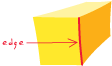
In a network system, a line feature through which a substance, resource, or traffic flows. Examples include a street in a transportation network and a pipeline in a sewer system. In a geometric network, a network edge can be simple or complex. A simple edge is always connected to exactly two junction features, one at each end. A complex edge is always connected to at least two junction features at its endpoints, but it can also be connected to additional junction features along its length. In a network dataset, a network edge is only connected to two junctions at its endpoints.
In a TIN data model, a line segment between nodes (sample data points). Edges store topologic information about the faces that they border.
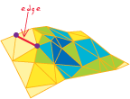
In network datasets, a connectivity policy that defines how one edge may connect to another edge mid-span. There are two edge-edge connectivity policies: endpoint connectivity and any-vertex connectivity.
See also junction connectivity policy, connectivity policy, endpoint connectivity, any-vertex connectivity.In geometric networks, a connectivity rule that defines how one edge may connect to another edge through a junction.
In connectivity relationships for networks, the number of edges of one type that may be associated with junctions of another type. Edge-junction cardinality defines a range of permissible connections that may occur in a one-to-many relationship between a single junction and many edges.
In geometric networks, a connectivity rule that defines how an edge may connect to a junction.
A spatial adjustment process that aligns features along the edge of an extent to the corresponding features in an adjacent extent.
See also rubber sheeting.
The portion of a coverage where the geometry (or geographical features) has been altered, but where topology has not yet been restored.
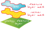
In ArcMap, a set of tools that allows the creation and modification of features and their attributes.
In ArcMap, the environment in which spatial and attribute editing take place. After starting an edit session, a user can modify feature locations, geometry, or attributes. Modifications are not saved unless the user explicitly chooses to save them.
In ArcMap, a temporary sketch that is used to perform a variety of tasks. Creating an edit sketch is a standard way to edit feature geometry.
During editing in ArcMap, a setting in the Task drop-down list that determines which operation the sketch construction tools will perform. Examples of edit tasks include creating new features and modifying existing features. The edit task is set by clicking a task in the Task drop-down list.
Acronym for ESRI Developer Network. A subscription program used to acquire ESRI software for developers, which includes a special program for supporting the ESRI developer community. EDN is intended to promote collaboration and interaction among GIS developers and ESRI staff.
A mapping system that displays but does not allow for the spatial analysis of data.
In geoprocessing in ArcGIS, a component of a model. Elements can be variables, such as input and derived data, or tools.
The vertical distance of a point or object above or below a reference surface or datum (generally mean sea level). Elevation generally refers to the vertical height of land.
See also altitude.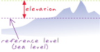
A map element that displays a simplified representation of the terrain within a map's extent. Elevation guides are designed to provide a quick overview of topography, including the high and low points.
See also elevation tints.A layer in ArcGlobe that has been categorized to help define the geometry of the globe surface.
Hypsometric tint bands based on elevation ranges used in an elevation guide.
See also elevation guide.A geometric shape described mathematically as the collection of points whose distances from two given points (the foci) add up to the same sum. An ellipse is shaped like a circle viewed obliquely.
A three-dimensional, closed geometric shape, all planar sections of which are ellipses or circles. An ellipsoid has three independent axes, and is usually specified by the lengths a,b,c of the three semi-axes. If an ellipsoid is made by rotating an ellipse about one of its axes, then two axes of the ellipsoid are the same, and it is called an ellipsoid of revolution, or spheroid. If the lengths of all three of its axes are the same, it is a sphere.

When used to represent the earth, an oblate ellipsoid of revolution, made by rotating an ellipse about its minor axis.
A multipoint feature class embedded into a terrain dataset. When a feature class is embedded, it is incorporated directly into the terrain pyramid and the terrain becomes the sole container of the data. Embedded feature classes can be used to reduce the amount of disk space required by mass point data such as lidar.
See also feature class.That property of a quantity that indicates that the quantity depends on data, observations, or experiment only; that is, it is not a model or part of a model. An empirical semivariogram is computed on data only, in contrast to a theoretical semivariogram model.
In geometric networks, a network feature that allows flow to pass through it.
Acronym for electronic navigational chart. A vector data product used for nautical navigation. ENC data is produced by nautical charting agencies throughout the world and uses the IHO (International Hydrographic Organization) S-57 standard for its database structure and attribution.
A file describing the contents of an item included in metadata. Enclosing files in metadata works the same way as enclosing files in an e-mail message.
In linear referencing, a special type of hatch definition that draws hatch marks only at the low and high measure of a linear feature.
An adjustable value that dictates how far away from the end of a line an address location should be placed. Using an end offset prevents the point from being placed directly over the intersection of cross streets if the address happens to fall on the beginning or end of the street.
See also side offset.In network datasets, a type of edge connectivity policy that states that an edge may only connect to another edge at its endpoints.
See also connectivity policy, edge connectivity policy, any-vertex connectivity.In remote sensing, applying operations to raster data to improve appearance or usability by making specific features more detectable. Such operations can include contrast stretching, edge enhancement, filtering, smoothing, and sharpening.
A geographic information system that is integrated through an entire organization so that a large number of users can manage, share, and use spatial data and related information to address a variety of needs, including data creation, modification, visualization, analysis, and dissemination.
See also GIS.The rectangle surrounding one or more geographical features in coordinate space, determined by the minimum and maximum coordinates in the x and y directions, as well as the ranges of any z- or m-values that the features may have. An envelope can be used to filter data for analysis.
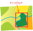
Settings that can apply to all tools within the application, all tools within a model or script, or a particular process within a model or script. Environment settings include current workspace, output spatial reference, output spatial grids, cell size, and tile size. They are generally set before running tools.
A data classification method that divides polygon features into groups so that the total area of the polygons in each group is approximately the same.
See also classification, equal-interval classification.A projection in which the whole of the map as well as each part has the same proportional area as the corresponding part of the earth. An equal-area projection may distort shape, angle, scale, or any combination thereof. No flat map can be both equal-area and conformal.
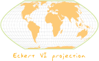
A trade area boundary set halfway between a store or service point and its neighboring stores or service points.
A data classification method that divides a set of attribute values into groups that contain an equal range of values.
See also classification, equal-area classification.The parallel of reference that is equidistant from the poles and defines the origin of latitude values.

A planar (or azimuthal) projection with its central point located at the equator.
A projection that maintains scale along one or more lines, or from one or two points to all other points on the map. Lines along which scale (distance) is correct are the same proportional length as the lines they reference on the globe. In the sinusoidal projections, for example, the central meridian and all parallels are their true lengths. An azimuthal equidistant projection centered on Chicago shows the correct distance between Chicago and any other point on the projection, but not between any other two points.
See also projection.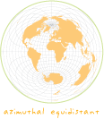
In ArcInfo, a command that removes or deletes features from one coverage that overlap features in another coverage.
In Survey Analyst for field measurements, a method of transferring statistical information about the spatial quality of survey points to other survey points.
A geodatabase table used by the GIS Data ReViewer to track error information through the quality control process. Defects are recorded, resolved and verified in the error table.
See also GIS Data ReViewer.An ESRI data format for storing raster data that defines geographic space as an array of equally sized square cells arranged in rows and columns. Each cell stores a numeric value that represents a geographic attribute (such as elevation) for that unit of space. When the grid is drawn as a map, cells are assigned colors according to their numeric values. Each grid cell is referenced by its x,y coordinate location.
In spatial modeling, the process of forming a statistic from observed data to assign optimal parameters in a model or distribution.
See also prediction.The straight-line distance between two points on a plane. Euclidean distance, or distance "as the crow flies," can be calculated using the Pythagorean theorem.
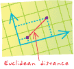
In ArcGIS Spatial Analyst, a description of each raster cell's relationship to the closest source.
See also Euclidean distance, source.A function that determines attribute values for network elements in a network dataset. If a network source does not have an evaluator, the default evaluator for its element type is used.
A geographic location stored in tabular rather than spatial form. Event types include address events, route events, x,y events, and temporal events.
In computing, an outcome or occurrence that happens when a user interacts with an application. For example, in a case in which clicking a button triggers the closing of a form, the event is the closing of the form.
In ArcGIS, a layer created from an event table.
See also event table.In linear referencing, an operation that produces a route event table that is the logical intersection or union of two input route event tables. Event overlay is one way to perform line-on-line, line-on-point, and event point-on-point overlays.
See also event, route event.A data source containing location information in tabular format (called events) that is used to create a spatial dataset. For example, an event table might contain x,y coordinates or routes.
See also event, event layer.In ArcView 3.x, a spatial data theme created from an event table.
An error that is an acceptable violation of a topology rule. In ArcMap, for example, a cul-de-sac is a legitimate exception to the rule that prohibits dangles.
A binary file containing a program that can be run as a stand-alone application. In the Microsoft Windows program, executable files are designated with an .exe extension.
The condition of a tool upon closure. If a tool fails due to a programming bug or command failure, the exit state will be "failed."
An editing process that separates a multipart feature into its component features, which become independent features.
See also multipart feature.
In mathematics, a number that indicates how many times a base value is multiplied by itself. Exponents are usually indicated with superscripts.
See also power.A sequence of operands and operators constructed according to the syntactic rules of a symbolic language that evaluates to a single number, string, or value.
In AutoCAD, extra optional data attached to an AutoCAD drawing element.
In ArcGIS, an optional software module that adds specialized tools and functionality to ArcGIS Desktop. ArcGIS Network Analyst, ArcGIS StreetMap, and ArcGIS Business Analyst are examples of ArcGIS extensions.
The minimum bounding rectangle (xmin, ymin and xmax, ymax) defined by coordinate pairs of a data source. All coordinates for the data source fall within this boundary.
A rectangle that is displayed in one data frame, showing the size and position of another data frame.
A specification that defines parameters for feature extraction and attribution. Specifications typically include the size of features to be collected, density of feature collection, scale ranges, and attribute assignment.
See also data dictionary.An ArcToolbox wizard that selects features from a coverage based on attribute values to create a new coverage.
Using known or observed data to infer or calculate values for unobserved times, locations or other variables outside a sampled area. In the absence of data, extrapolation is a common method for making predictions, but it is not always accurate. For example, based on observed economic indicators, an economist can make predictions about the state of the economy at a future time. These predictions may not be accurate because they cannot take into account seemingly random events such as natural disasters.
The process of projecting features in a two-dimensional data source into a three-dimensional representation: points become vertical lines, lines become planes, and polygons become three-dimensional blocks. Uses of extrusion include showing the depth of well point features or the height of building-footprint polygons.
In a TIN, the flat surface of a triangle bounded by three edges and three nodes. Faces do not overlap; each face is adjacent to three other faces of the TIN. A face defines a plane with an aspect and slope.
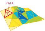
In ArcGIS Network Analyst, a network location used in closest facility and service area analyses.
See also closest facility analysis, service area analysis.The linear value added to all x-coordinates of a map projection so that none of the values in the geographic region being mapped are negative.
The linear value added to all y-coordinates of a map projection so that none of the values in the geographic region being mapped are negative.
A representation of a real-world object on a map.
See also point feature, polygon feature, multipoint feature, polyline feature, multipart feature.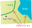
In ArcGIS, a collection of geographic features with the same geometry type (such as point, line, or polygon), the same attributes, and the same spatial reference. Feature classes can be stored in geodatabases, shapefiles, coverages, or other data formats. Feature classes allow homogeneous features to be grouped into a single unit for data storage purposes. For example, highways, primary roads, and secondary roads can be grouped into a line feature class named "roads." In a geodatabase, feature classes can also store annotation and dimensions.
See also object class.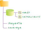
In Survey Analyst for field measurements, a block of text included in data collector file format, used to describe features surveyed in the field.
Data that represents geographic features as geometric shapes.
In ArcGIS, a collection of feature classes stored together that share the same spatial reference; that is, they share a coordinate system, and their features fall within a common geographic area. Feature classes with different geometry types may be stored in a feature dataset.
A layer that references a set of feature data. Feature data represents geographic entities as points, lines, and polygons.
See also layer.Annotation that is stored in the geodatabase with links to features through a geodatabase relationship class. Feature-linked annotation reflects the current state of features in the geodatabase: it is automatically updated when features are moved, edited, or deleted.
A table in an ArcSDE geodatabase that stores geometric shapes for each feature. Feature tables are used in geodatabases that store data as a binary data type, such as SQL Server geodatabases. They are related to the business table of a feature class through the feature ID. In the database, feature table names are prefaced with an f and are stored in the schema of the user who owns the feature class.
Acronym for Federal Geographic Data Committee. An organization established by the United States Federal Office of Management and Budget responsible for coordinating the development, use, sharing, and dissemination of surveying, mapping, and related spatial data. The committee is comprised of representatives from federal and state government agencies, academia, and the private sector. The FGDC defines spatial data metadata standards for the United States in its Content Standard for Digital Geospatial Metadata and manages the development of the National Spatial Data Infrastructure (NSDI).
See also NSDI.A column in a table that stores the values for a single attribute.
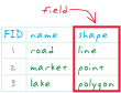
The place in a database record, or in a GUI, where data can be entered.
A synonym for surface.
In geoprocessing, defining the field structure and content for an output dataset.
The number of digits that can be stored in a field in a table.
See also dataset precision.The number of decimal places for float or double-type geodatabase table fields.
A collection of uniquely named information stored on a drive, disk, or tape. A file generally resides within a directory.
A geodatabase stored as a folder of files. A file geodatabase can be used simultaneously by several users, but only one user at a time can edit the same data.
See also geodatabase.The interior of a polygon; the area inside the perimeter.
A segment of a circle used to connect two intersecting lines. Fillets are used to create smoothly curving connections between lines, such as pavement edges at street intersections or rounded corners on parcel features.

A desktop GIS operation used to hide (but not delete) features in a map document or attribute table.
See also focal analysis.An ArcWeb tool for ArcGIS that lets users generate multipoint driving directions between user-defined locations. The Find Route tool determines the shortest or the quickest path between locations and creates a map of the travel route and a list of travel directions.
See also least-cost path.A process that seeks out new market areas based on the characteristics of an existing market area.
In Survey Analyst for field measurements, a survey point used as an input to a computation. The coordinates are not updated by the computation.
In ArcGIS Tracking Analyst, stored temporal data that can be viewed in past, future, and past-and-future time windows. This data is stored in a shapefile or as a feature class in a geodatabase.
A marker that identifies or calls attention to something, indicating importance or the need for further attention.
In ArcMap, a temporary graphic that is placed on a geometric network to specify the starting point, stops, or endpoint for a trace task.
A measure of how much an oblate spheroid differs from a sphere. The flattening equals the ratio of the semimajor axis minus the semiminor axis to the semimajor axis.
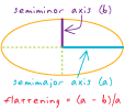
A layer in ArcGlobe that has been categorized to float independently above or below the globe surface.
A type of numeric field for storing real numbers with a decimal point. The decimal point can be in any position in the field and, thus, may "float" from one location to another for different values stored in the field. For example, a floating-point field can store the numbers 23.632, 0.000087, and -96432.15.
The route or course followed by commodities proceeding through edge elements in a network.
The computation of an output raster where the output value at each cell location is a function of the value at that cell location and the values of the cells within a specified neighborhood around the cell.
In Survey Analyst for field measurements, the field that is the current target for data entry.
A location on a disk containing a set of files, other folders, or both.
In ArcCatalog, a top-level item in the Catalog tree that provides quick access to geographic data stored on local disks (including CD-ROMs) or shared on a network. Folder connections may provide access to individual folders.
In ArcGIS, a method for placing geodatabase annotation relative to a line or polygon feature. For example, text next to a river may be dragged along it so that the text curves like the river.
In ArcGIS Image Server, the extent (often rectangular) of each raster dataset in the image service definition. The footprint is stored as a polygon shapefile within the image service definition.
See also extent.In MOLE, a component of a map display that shows where force units are located so that the map reader can see where forces are the strongest and weakest.
See also convex hull.In MOLE, a type of graphic that represents a military unit (such as Company A, 1st Battalion of the 135th Infantry), equipment, or installation (such as a hospital or radar site). Force elements are also known as force units or military units.
See also tactical graphic, leader, stack, war fighting symbol.In a scene or display, the area that appears to be closest to an observer.
The area in a raster layer where cells are eligible for selection and vectorization.
An attribute or set of attributes in one table that match the primary key attributes in another table. Foreign keys and primary keys are used to join tables in a database.
In computing, the structure and organization of digital information.
In MOLE, the geometric border of a graphic that indicates the affiliation, battle dimension, and status of the war fighting element that the MOLE graphic represents.
See also graphic component.In Survey Analyst for field measurements, one of two phases involved when performing a least squares adjustment for a measurement network. The free network adjustment phase examines the overall geometry of the network by processing only the measurements and using the reference points only for position scale and orientation of the network. The emphasis is on testing the quality of the measurements rather than computing the coordinates.
In ArcGIS, the representation of a single feature that has been disconnected from its representation rule to create an independent rule whose structure can be changed, allowing full freedom of display. Geometric effects within the rule can be converted so that their results become static parts of the feature representation.
To fix a column in place in a table for better viewing of the table's contents. A frozen column will stay in place while the other columns scroll normally.
Of an arc's two endpoints, the first one digitized. From- and to-nodes give an arc left and right sides and, therefore, direction.
See also to-node.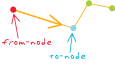
A ratio of variances, calculated from a sample of data and used to provide information about a whole dataset. For example, statistic F may be used to provide estimates of variance, or differences, in a population, based on observations from two or more random samples.
A statistical test for determining the probability that the variances of two different samples are the same. The F test uses a statistic known as statistic F to test statistical hypotheses about the variances of distributions from which samples have been drawn.
Acronym for File Transfer Protocol. A protocol that allows the transmission of files between computers over a network.
An operation. In GIS, functions include data input, editing, and management; data query, analysis, and visualization; and output operations.
See also tool.In 3D Analyst, a surface that stores a single z-value for any given x,y location.
The distance within which coordinates of nearby features are adjusted to coincide with each other when topology is being constructed or polygon overlay is performed. Nodes and vertices within the fuzzy tolerance are merged into a single coordinate location. Fuzzy tolerance is a very small distance, usually from 1/1,000,000 to 1/10,000 times the width of the coverage extent, and is generally used to correct inexact intersections.
A project management graph that displays tasks on a schedule, often used to plan and track projects. The Gantt chart was developed by the American mechanical engineer and management consultant Henry Laurence Gantt.
A projected coordinate system that uses the transverse Mercator projection to divide the world into standard zones 6 degrees wide. Used mainly in Europe and Asia, the Gauss-Kr�ger coordinate system is similar to the universal transverse Mercator coordinate system. The Gauss-Kr�ger projection is named for the German mathematician and scientist Karl Friedrich Gauss and the German geodesist and mathematician Johann Heinrich Louis Kr�ger.
The abstraction, reduction, and simplification of features for change of scale or resolution.
The process of reducing the number of points in a line without losing the line's essential shape.
The process of enlarging and resampling cells in a raster format.
A three-dimensional, earth-centered reference system in which locations are identified by their x-, y-, and z-values. The x-axis is in the equatorial plane and intersects the prime meridian (usually Greenwich). The y-axis is also in the equatorial plane; it lies at right angles to the x-axis and intersects the 90-degree meridian. The z-axis coincides with the polar axis and is positive toward the north pole. The origin is located at the center of the sphere or spheroid.

A horizontal geodetic datum based on an ellipsoid that has its origin at the earth's center of mass. Examples are the World Geodetic System of 1984, the North American Datum of 1983, and the Geodetic Datum of Australia of 1994. The first uses the WGS84 ellipsoid; the latter two use the GRS80 ellipsoid. Geocentric datums are more compatible with satellite positioning systems, such as GPS, than are local datums.
See also datum, GPS.The angle between the equatorial plane and a line from a point on the surface to the center of the sphere or spheroid. On a sphere, all lines of latitude are geocentric. Latitude generally refers to geodetic latitude.
A code representing the location of an object, such as an address, a census tract, a postal code, or x,y coordinates.
See also geocoding.A feature class created by batch geocoding.
See also feature class, batch geocoding.An ArcGIS Server software component that provides programmatic access to an address locator and performs single and batch address matching. It is designed for use in building Web services and Web applications using ArcGIS Server.
A GIS operation for converting street addresses into spatial data that can be displayed as features on a map, usually by referencing address information from a street segment data layer.
An entity in the geocoding framework that drives the geocoding process.
An index on reference data used by an address locator to search for matching records in the reference data. A geocoding index is either a file or a database table containing index attributes used by the address locator.
The steps involved in translating an address entry, searching for the address in the reference data embedded in an address locator, and delivering the best candidate or candidates. These steps include parsing the address, standardizing abbreviated values, assigning each address element to a category known as a match key, indexing the needed categories, searching the reference data, assigning a score to each potential candidate, filtering the list of candidates based on the minimum match score, and delivering the best match. The process requires reference files, input address records, address locators, and software.
See also address locator.Data that a geocoding service uses to determine the geometric representations for locations.
A collection of files that directs the geocoding engine in how to standardize address data and match it to the related location in the reference data. Each address locator style uses a specific rule base designed for that style.
A template on which a geocoding service is built. Each template is designed to accommodate a specific format of address and reference data, and geocoding parameters. Geocoding style template files have a .lot file extension.
A database or file structure used primarily to store, query, and manipulate spatial data. Geodatabases store geometry, a spatial reference system, attributes, and behavioral rules for data. Various types of geographic datasets can be collected within a geodatabase, including feature classes, attribute tables, raster datasets, network datasets, topologies, and many others. Geodatabases can be stored in IBM DB2, IBM Informix, Oracle, Microsoft Access, Microsoft SQL Server, and PostgreSQL relational database management systems, or in a system of files, such as a file geodatabase.
See also database.The schema for the various geographic datasets and tables in an instance of a geodatabase. The schema defines the GIS objects, rules, and relationships used to add GIS behavior and integrity to the datasets in a collection.
See also database.In ArcGIS, a method of distributing data across two or more geodatabases in order to synchronize data changes. An entire geodatabase or a subset of a geodatabase can be replicated. There are three types of geodatabase replication: two-way replication, one-way replication, and check-out replication.
See also replication.In ArcGIS, a coarse-grained object that represents a geodatabase. It allows software users to perform replication operations, data extraction and database query operations on a geodatabase over the WAN using ArcGIS Server. Application developers can also use the GeoDataServer with geodatabase connections made over the LAN.
Any organized collection of data in a geodatabase with a common theme.
The shortest distance between two points on the surface of a spheroid. Any two points along a meridian form a geodesic.
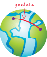
A datum that is the basis for calculating positions on the earth's surface or heights above or below the earth's surface.
See also datum.The angle that a line drawn perpendicular to the surface through a point on a spheroid makes with the equatorial plane.
A measurement of a location on the earth's surface expressed in degrees of latitude and longitude.
See also geographic coordinate system.A reference system that uses latitude and longitude to define the locations of points on the surface of a sphere or spheroid. A geographic coordinate system definition includes a datum, prime meridian, and angular unit.
See also datum, angular unit.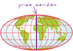
Information describing the location and attributes of things, including their shapes and representation. Geographic data is the composite of spatial data and attribute data.
See also spatial data, attribute data.A systematic conversion of the latitude-longitude values for a set of points from one geographic coordinate system to equivalent values in another geographic coordinate system. Depending on the geographic coordinate systems involved, the transformation can be accomplished in various ways. Typically, equations are used to model the position and orientation of the "from" and "to" geographic coordinate systems in three-dimensional coordinate space; the transformation parameters may include translation, rotation, and scaling. Other methods, including one used in transformations between NAD 1927 and NAD 1983, use files in which the differences between the two geographic coordinate systems are given for a set of coordinates; the values of other points are interpolated from these.
See also geographic coordinate system.A hypothetical surface representing the form the earth's oceans would take if there were no land and the water were free to respond to the earth's gravitational and centrifugal forces. The resulting geoid is irregular and varies from a perfect sphere by as much as 75 meters above and 100 meters below its surface.
See also ellipsoid, spheroid.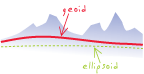
The height of the geoid above the ellipsoid.
The process of creating geographic features from tabular data by matching the tabular data to a spatial location. An example of geolocation is creating point features from a table of x,y coordinates.
The distance within which features in a geometric network are deemed to be coincident and, therefore, connected.
See also coincident.The correction of errors in remotely sensed data, such as those caused by satellites or aircraft not staying at a constant altitude or by sensors deviating from the primary focus plane. Images are often compared to ground control points on accurate basemaps and resampled, so that exact locations and appropriate pixel values can be calculated.
In ArcGIS, a dynamic process that can be applied within a representation rule to dynamically alter the geometry of features before they are drawn. Geometric effects can act on a single symbol layer, or on all symbol layers in a representation rule, and can be chained together to create cumulative effects.
One of the most basic parts or components of a geometric figure: that is, a surface, shape, point, line, angle, or solid.
Edge and junction features that represent a linear network, such as a utility or hydrologic system, in which the connectivity of features is based on their geometric coincidence. A geometric network does not contain information about the connectivity of features; this information is stored within a logical network. Geometric networks are typically used to model directed flow systems.
See also logical network, directed network flow.
The process of rectifying a raster dataset to map coordinates or converting a raster dataset from one coordinate system to another.
The measures and properties of points, lines, and surfaces. In a GIS, geometry is used to represent the spatial component of geographic features.
A GIS operation used to manipulate GIS data. A typical geoprocessing operation takes an input dataset, performs an operation on that dataset, and returns the result of the operation as an output dataset. Common geoprocessing operations include geographic feature overlay, feature selection and analysis, topology processing, raster processing, and data conversion. Geoprocessing allows for definition, management, and analysis of information used to form decisions.
A computer in a network that is used to handle geoprocessing tasks. Geoprocessing servers may use UNIX or Windows platforms, and include a utility to schedule remote processing.
Any settings that affect working with or running tools. Geoprocessing settings include the state of the ArcToolbox window, the state of the Environment Settings dialog box, and variables that have been created at the command line. In ArcMap, geoprocessing settings are saved with a map document. In ArcCatalog, geoprocessing settings are persisted with the application.
Aligning geographic data to a known coordinate system so it can be viewed, queried, and analyzed with other geographic data. Georeferencing may involve shifting, rotating, scaling, skewing, and in some cases warping, rubber sheeting, or orthorectifying the data.
See also transformation.A geographic data model that represents geographic features as an interrelated set of spatial and attribute data. The georelational model is the fundamental data model used in coverages.
Positioned in an orbit above the earth's equator with an angular velocity the same as that of the earth and an inclination and eccentricity approaching zero. A geostationary satellite will orbit as fast as the earth rotates on its axis, so that it remains effectively stationary above a point on the equator. A geostationary satellite is geosynchronous, but geosynchronous satellites are not necessarily geostationary.
A layer file created by the ArcGIS Geostatistical Analyst extension. It can be exported to ESRI GRID for further geoprocessing.
The software module in Survey Analyst - Cadastral Editor that manages the interaction between cadastral fabric jobs and the cadastral fabric.
Acronym for geographic information system. An integrated collection of computer software and data used to view and manage information about geographic places, analyze spatial relationships, and model spatial processes. A GIS provides a framework for gathering and organizing spatial data and related information so that it can be displayed and analyzed.
See also spatial data, analysis, spatial analysis, model.In Survey Analyst for field measurements, the single coordinate for a survey point that is the best overall representation for that survey point's location, defined by one or more projects. Feature geometry is always linked to the GIS coordinate.
An application used to manage data quality control, visually check data and run batch checks for attribute and geometry defects. Defects are recorded in an error table that can be used to resolve errors and verify corrections.
The computation of an output raster where the output value at each cell location may be a function of all the cells in the input raster.
See also local analysis, spatial function.In Survey Analyst for field measurements, one of two ways to apply the Coordinate Out of Tolerance command. The Global Check method searches for coordinates out of tolerance within the whole survey dataset.
A field of type UUID (Universal Unique Identifier) in which values are automatically assigned by the geodatabase when a row is created. The GlobalID field is necessary for maintaining object uniqueness across replicas. All feature classes and tables participating in one-way or two-way replication must contain the GlobalID field. This field is not editable and is automatically populated when it is added for existing data.
In ArcGIS Geostatistical Analyst, a deterministic interpolation method. The interpolated surface is not required to conform to the sample data points, and the method does not have standard errors associated with it.
See also interpolation.In ArcGlobe, the sphere in a globe view on which data is depicted.
A disk-based representation of the globe view or views contained in ArcGlobe. Globe documents have a .3dd extension.
In ArcGlobe, properties that can be set for a globe document. These include vertical exaggeration, background color, or sun position.
In ArcGlobe, a globe surface with base heights supplied from an elevation layer.
In ArcGlobe, the display window in which a globe can be viewed.
The geometric shape of a character in a font.
Acronym for Geography Markup Language. An OpenGIS Implementation Specification designed to store and transport geographic information. GML is a profile (encoding) of XML.
See also XML.Acronym for Global Positioning System. A system of radio-emitting and -receiving satellites used for determining positions on the earth. The orbiting satellites transmit signals that allow a GPS receiver anywhere on earth to calculate its own location through trilateration. Developed and operated by the U.S. Department of Defense, the system is used in navigation, mapping, surveying, and other applications in which precise positioning is necessary.
A unit of angular measurement in which the angle of a full circle is 400 gradians and a right angle is 100 gradians. The common abbreviation for gradian is grad.
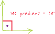
A map on which a range of colors indicates a progression of numeric values. For example, increases in population density might be represented by the increased saturation of a single color, or temperature differences by a sequence of colors from blue to red.
A map with symbols that change in size according to the value of the attribute they represent. For example, denser populations might be represented by larger dots, or larger rivers by thicker lines.
An image produced by and stored in a computer as data for display.
In MOLE, the most elementary part of a graphic. Icon, frame, and fill are examples of components that make up MOLE graphics.
See also frame, icon, fill.Text added in ArcMap layout view that exists in page space and is stored in a map document. Graphic text does not move if the extent or scale is changed.
See also label, annotation, text formatting tag.A network of longitude and latitude lines on a map or chart that relates points on a map to their true locations on the earth.

A glass plate or cell with a grid or cross wires on it that rests in the focal plane of the eyepiece of a telescope, used to locate and measure celestial objects.
A label positioning method in which labels are oriented along the graticule of the data frame. This is useful for maps of large areas, for cartographic or stylistic reasons.
See also label orientation.The idea that the probability of a given consumer visiting and purchasing at a given site is some function of the distance to that site, the site's attractiveness, and the distance and attractiveness of competing sites.
See also attractiveness.Any circle or near circle produced by the intersection of the surface of a sphere and a flat plane that passes through the center of the sphere. The equator and all lines of longitude are great circles. Great circles are used in navigation, since the shortest path between any two points on the earth's surface lies on a great circle.
The meridian adopted by international agreement in 1884 as the prime meridian, the 0-degree meridian from which all other longitudes are calculated. The Greenwich prime meridian runs through the Royal Observatory in Greenwich, England.
In cartography, any network of parallel and perpendicular lines superimposed on a map and used for reference. These grids are usually referred to by the map projection or coordinate system they represent, such as universal transverse Mercator grid.
See raster.
In Survey Analyst for field measurements, any meridian that is parallel to the central meridian, used when computing points in planar rectangular coordinate systems of limited extent.
A mechanism for storing multivariate raster data in ESRI software, consisting of an ordered set of spatially overlapping grids (referred to as layers) referenced by an INFO file or geodatabase. A stack is treated as a single entity for multivariate analysis. Cluster analysis, classification, and principal component analysis all work on the layers in a stack.
In ArcGIS Online, a way to collaborate with other ArcGIS users and to exchange content related to a specific project or common activity.
A group of several layers that appear and act as a single layer. Group layers make it easier to organize a map, assign advanced drawing order options, and share layers for use in other maps.
A process that connects to a relational database management system (RDBMS), using the RDBMS server libraries, and becomes the dedicated link for a GIS client to the database. A gsrvr process is only used in three-tiered geodatabase connections. The GIS client sends instructional commands to the gsrvr process on how to build appropriate SQL statements to perform the requested spatial action (pan, zoom, and so on).
Acronym for graphical user interface. A software display of program options that allows a user to choose commands by pointing to icons, dialog boxes, and lists of menu items on the screen, typically using a mouse. This contrasts with a command line interface in which control is accomplished via the exchange of strings of text.
See also command line interface.Acronym for globally unique identifier. A string used to uniquely identify an interface, class, type library, component category, or record.
Acronym for High Accuracy Reference Network. A regional or statewide resurvey and readjustment of NAD 1983 control points using GPS techniques. The resurvey date is often included as part of the datum name: NAD 1983 (1991) or NAD91.
In linear referencing, a group or category of hatch definitions.
In linear referencing, a specification for where hatch marks are drawn on a line feature. Each hatch definition has its own set of properties that include the multiple of the hatch interval at which the hatches in the hatch definition will be placed, the line or marker symbol of the hatches, and whether the hatches will be labeled. The use of multiple hatch definitions allows for the design of complex hatching schemes.
In linear referencing, a series of vertical line or marker symbols displayed on top of features at an interval specified in route measure units.
In linear referencing, a type of labeling that posts and labels hatches or symbols at a regular interval along measured line features.
In linear referencing, an organized collection of symbols and settings for the hatch definitions that make up a hatch class. Hatch styles are stored in a style file (.style) and created by the user to maintain standards for displaying hatches on multiple maps with multiple data sources.
Acronym for horizontal dilution of precision. A measure of the geometric quality of a GPS satellite configuration in the sky. HDOP is a factor in determining the relative accuracy of a horizontal position. The smaller the DOP number, the better the geometry.
Manual digitization by tracing a mouse over features displayed on a computer monitor, used as a method of vectorizing raster data.
See also digitizing.The vertical distance between two points, or above a specified datum.
A geometric transformation that scales, rotates, or translates images or coordinates between any two Euclidean spaces. It is commonly used in GIS to transform maps between coordinate systems. In a Helmert transformation, parallel lines remain parallel. The midpoint of a line segment remains a midpoint, and all points on a straight line remain on a straight line. The Helmert transformation is named for the German mathematician and geodesist Friedrich Robert Helmert (1843-1917).
See also transformation, affine transformation.In ArcGIS 8.3 and previous versions, a branch in the ArcToolbox tree providing overview help for ArcToolbox toolsets.
A type of network attribute for a network element in a network dataset. Hierarchy can be used during network analysis to assign priority to a network element. For example, in a transportation network dataset, a "road class" hierarchy can be assigned to edges to favor major roads instead of local streets.
See also network dataset, network attribute.
Shadows drawn on a map to simulate the effect of the sun's rays over the varied terrain of the land.
The hypothetical illumination of a surface according to a specified azimuth and altitude for the sun. Hillshading creates a three-dimensional effect that provides a sense of visual relief for cartography, and a relative measure of incident light for analysis.
A graph showing the distribution of values in a set of data. Individual values are displayed along a horizontal axis, and the frequency of their occurrence is displayed along a vertical axis.
In ArcMap, a user-created reference to a time and date stamp. Historical markers can be used to easily connect to a historical version for a specific date and time.
See also historical version.In ArcMap, a version that a user connects to by using a historical marker or indicating a particular date and time. Once connected, the version provides a read-only view of the geodatabase for the chosen time.
See also historical marker.In Survey Analyst - Cadastral Editor, a parcel that has been replaced with a new parcel by subdivision, merge, or other means due to a change in the survey record.
A model created, dated, and saved when the application is closed to document the tools and parameter values used for each session. The history model is contained within the history toolbox and can be viewed when the application is reopened.
See also model.A small gap in a raster line feature, usually considered to be an error caused by the poor quality of a source document or by the scanning process.
In network datasets, a type of junction connectivity policy in which junctions connect to other junctions based on the edge connectivity policy set by the user; junctions "honor" the existing edge connectivity policy.
See also junction connectivity policy, override.The angle formed by the intersection of two lines in a horizontal plane.
Acronym for Hypertext Markup Language. A markup language used to create Web pages for publication on the Internet. HTML is a system of tags that define the function of text, graphics, sound, and video within a document, and is now an Internet standard maintained by the World Wide Web Consortium.
A reference (link) from one point in an electronic document to another document or another location in the same document (the target). Activating the link, usually by clicking it with the mouse, causes the browser to display the target of the link.
Acronym for International Civil Aviation Organization. A member organization that represents the worldwide body of nations for standardizing flight rules, regulations, and requirements.
In MOLE, the innermost graphic component of a graphic. Icons represent the Function ID position of a Symbol ID code.
See also graphic component, war fighting element.In ArcGIS, a tool that, when applied to a feature (by clicking it), opens a window showing that feature's attributes.
In geoprocessing, a topological overlay that computes the geometric intersection of two datasets. The output dataset preserves all the features of the first dataset plus those portions of the second (polygon) dataset that overlap the first. For example, a road passing through two counties would be split into two arc features, each with the attributes of the road and the county it passes through.
An anchor that prevents the movement of features during rubber sheeting.
See also rubber sheeting.The light incident on a surface or object, either natural or artificial, as determined by the surface's slope and aspect and by the sun's azimuth and altitude.
See also azimuth, altitude.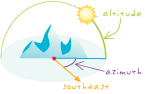
A representation or description of a scene, typically produced by an optical or electronic device, such as a camera or a scanning radiometer. Common examples include remotely sensed data (for example, satellite data), scanned data, and photographs.
In ArcGIS, a raster dataset.
Data produced by scanning a surface with an optical or electronic device. Common examples include scanned documents, remotely sensed data (for example, satellite images), and aerial photographs. An image is stored as a raster dataset of binary or integer values that represent the intensity of reflected light, heat, or other range of values on the electromagnetic spectrum.
In ArcGIS Image Server, a rendered image that users load from the server. The image service appears to the user as a virtual image. Some properties of a service may be defined by the client application.
In ArcGIS Server, a type of Web service that is generated from image data.
In ArcGIS Image Server, a workspace created using the Image Service Definition Editor toolbar that defines the key properties of a service, including name and default spatial reference system. The image service definition workspace has a .ISDef extension.
In ArcGIS Image Server, a file that stores properties for reestablishing a connection to a service and setting up user-defined image service properties. Image service reference files have a .ISRef extension.
A measure of the amount of resistance, or cost, required to traverse a path in a network, or to move from one element in the network to another. Resistance may be a measure of travel distance, time, speed of travel multiplied by distance, and so on. Higher impedance values indicate more resistance to movement, and a value of zero indicates no resistance. An optimum path in a network is the path of lowest impedance, also called the least-cost path.
See also least-cost path.In ArcGIS Network Analyst, a network location used in closest facility analysis. Car accidents, crime scenes, and fires are examples of incidents.
See also closest facility analysis.One or a set of variables used to model or predict the dependent variable. For example, a prediction of annual purchases for a proposed store (the dependent variable) might include independent variables representing the number of potential customers, distance to competition, store visibility, and local spending patterns. In the regression equation, independent variables appear on the right side of the equal sign and are often referred to as explanatory variables.
See also dependent variable, regression equation.In networks, a flow direction that is unknown or undiscoverable. Indeterminate flow direction occurs when flow direction cannot be determined from the connectivity of the network, the locations of sources and sinks, and the enabled or disabled states of features.
A data structure, usually an array, used to speed the search for records in a database or for spatial features in geographic datasets. In general, unique identifiers stored in a key field point to records or files holding more detailed information.
A tabular database management system used by ArcInfo Workstation software to store and manipulate attributes of a GIS dataset in ArcInfo Workstation format. INFO databases are stored inside a workspace folder with subdirectories containing files that represent the geometry and topology that make up a coverage.
A commercial relational database management system (RDBMS) supported by ArcSDE.
Data that is entered into a computer, device, program, or process.
In geocoding, a piece of information such as a customer address and location of an incident. Input event record types vary by application. They include customer addresses, location of the event or incident, location of equipment and facilities, and the monument offset.
In geoprocessing, data put into the system for processing, usually specified by a path in a dialog box, script, or at the command line.
In geoprocessing, tabular data put into the system for processing, usually specified by a path in a dialog box, script, or at the command line.
In the Survey Analyst for field measurements Survey Explorer, a field that allows the user to select the instrument setup or enter the name of a new instrument setup.
In geodatabases, a feature dataset that stores topologically associated feature classes. The topological editing tools in ArcMap can be used to maintain the topological associations of features in an integrated feature dataset. Network feature classes do not participate in the topological associations within an integrated feature dataset.
A manual process for converting raster data into vector features that involves tracing raster cells.
A file format that allows the easy exchange of data between different software programs.
One of two weights that allow control of how labels are placed relative to polygon features in ArcMap. Higher feature weights prevent labels from being placed over features. A high interior weight prevent labels from occupying the interior of polygon features.
Any data in a process that did not exist before the process existed and that will not be maintained after the process executes.
The estimation of surface values at unsampled points based on known surface values of surrounding points. Interpolation can be used to estimate elevation, rainfall, temperature, chemical dispersion, or other spatially-based phenomena. Interpolation is commonly a raster operation, but it can also be done in a vector environment using a TIN surface model. There are several well-known interpolation techniques, including spline and kriging.
In the context of linear referencing, the calculation of measure values for a route between two known measure values.
A geometric integration of spatial datasets that preserves features or portions of features that fall within areas common to all input datasets.
The point where two lines cross. In geocoding, most often a street crossing.
A character used in address data to indicate that an address is located at an intersection. For example, in the address "S. Huntington Dr. & E. Clark Blvd." the ampersand (&) character is the intersection connector. The intersection connector delimits the address into two parts and assigns intersection searches to the address.
In spatial statistics, the assumption that a set of data comes from a random process with a constant mean and a semivariogram that depends only on the distance and direction separating any two locations.
See also stationarity, semivariogram.An interpolation technique that estimates cell values in a raster from a set of sample points that have been weighted so that the farther a sampled point is from the cell being evaluated, the less weight it has in the calculation of the cell's value.
See also interpolation, weight.
Acronym for Internet protocol address. A unique number, such as 10.48.6.8, that identifies each computer on the Internet. IP addresses are similar to phone numbers, and allow data to travel between one computer and another via the Internet.
An isoline drawn according to values that can occur at points; an isometric line.
See also isoline.Abbreviation for International Organization for Standardization. A federation of national standards institutes from 145 countries that works with international organizations, governments, industries, businesses, and consumer representatives to define and maintain criteria for international standards.
A setting in a database management system (DBMS) that defines how much an application process is isolated from other concurrently executing processes in a DBMS. It specifies the degree to which the rows read and updated by the application are available to other concurrently executing processes. It also specifies the degree to which updates from other concurrently executing application processes are available to the application.
A line connecting points of equal value on a map. Isolines fall into two classes: those in which the values actually exist at points, such as temperature or elevation values, and those in which the values are ratios that exist over areas, such as population per square kilometer or crop yield per acre. The first type of isoline is specifically called an isometric line or isarithm; the second type is called an isopleth.
A property of a natural process or data where spatial dependence (autocorrelation) changes only with the distance between two locations—direction is unimportant.
See also anisotropy, autocorrelation.An element in the Catalog tree. Items include data sources, such as shapefiles and geodatabases, and nonspatial elements, such as folders.
A column of information in an INFO table.
In ArcGIS Online, a map, layer, or tool that you find, use, or add to ArcGIS Online.
The Java platform edition developed by Sun Microsystems for small, stand-alone, or connectable devices. Java ME enables development, deployment, and management of applications that can scale from mobile devices to desktop computers. In 2007, Sun replaced J2ME with Java ME.
A task scheduled on a computer for immediate or future processing. A job can involve a single task or a batch mode operation.
In Survey Analyst - Cadastral Editor, a tool that facilitates the viewing and management of cadastral fabric jobs.
See also cadastral fabric job.Acronym for joint operations graphic. A 1:250,000-scale topographic map used by militaries worldwide. Joint operations graphics use a common base graphic to facilitate operations involving air, ground, and naval forces.
See also TLM, VMap.In Survey Analyst - Cadastral Editor, a parcel that is connected to the cadastral fabric, and shares common points with neighboring parcels.
See also unjoined parcel.Appending the fields of one table to those of another through an attribute or field common to both tables. A join is usually used to attach more attributes to the attribute table of a geographic layer.
Connecting two or more features from different sets of data so that they become a single feature.
In Survey Analyst - Cadastral Editor, the process of connecting the points from an unjoined parcel to their corresponding points in the cadastral fabric.
Acronym for Job Tracking for ArcGIS. ESRI software used to track and manage database production workflow. It provides the ability to define tasks, set up production environments, manage geodatabase versioning and track database changes at the feature level. JTX also provides tools for allocating resources and tracking the status and progress of jobs.
For network data models in a geodatabase, a point at which two or more edges meet.
In a coverage, a node joining two or more arcs.
In network datasets, a connectivity policy that defines how a junction may connect to an edge. There are two junction connectivity policies: honor and override.
See also edge connectivity policy, connectivity policy, honor, override.An attribute or set of attributes in a database that uniquely identifies each record.
See also compound key, foreign key, primary key.A keystroke combination that executes a command that might otherwise require the use of a mouse. For example, Ctrl+C is a well-known keyboard shortcut for copying a selection in Windows.
In an animation in ArcMap, ArcScene, or ArcGlobe, a snapshot of an object's properties at a certain time.
A significant word from a document that is used to index or search content.
See also index.A database of information about a subject, used in expert systems.
In PLTS, a series of tables used for database and cartographic production. Knowledge base tables contain validation rules for feature attribution, data collection, and symbology.
A surveyed point that has an established x,y coordinate value. Known points are used in survey operations to extend survey computations into a project area.
An interpolation technique in which the surrounding measured values are weighted to derive a predicted value for an unmeasured location. Weights are based on the distance between the measured points, the prediction locations, and the overall spatial arrangement among the measured points. Kriging is unique among the interpolation methods in that it provides an easy method for characterizing the variance, or the precision, of predictions. Kriging is based on regionalized variable theory, which assumes that the spatial variation in the data being modeled is homogeneous across the surface. That is, the same pattern of variation can be observed at all locations on the surface. Kriging was named for the South African mining engineer Danie G. Krige (1919-).
See also interpolation.
In cartography, text placed on or near a map feature that describes or identifies it.
In MOLE, text based on attribute data. Labels are placed dynamically on or near features based on the military specifications that MOLE supports. In MOLE, labels are often referred to as modifiers.
In ArcMap, a category of labels that represents features with the same labeling properties. For example, in a roads layer, label classes could be created to define information and style for each type of road: interstate, state highway, county road, and so on.
A statement that determines the label text. Label expressions typically concatenate or modify the contents of one or more fields, and may add additional text strings to create more informative labels. They can contain Visual Basic script or JScript to add logic, text processing, and formatting for the labels.
In Maplex for ArcGIS, a tab on the Label Placement dialog box that allows control of the ways the label engine can fit more labels into a limited area. Methods that can increase label placement are stacking labels, reducing the font size of labels in congested areas, or abbreviating labels.
In ArcMap, the tool used to display and set labeling properties for the currently active data frame. The Label Manager is accessible through the Labeling toolbar.
The distance a label should be from the feature it labels. A label offset and a maximum label offset can be set for point features. Maximum label offsets are expressed as a percentage of the label offset. For line features, a label offset can be set from the line (similar to the label offset for point features) and along the line (which controls the position of the label relative to the ends of the line). Label offsets are not available for all label position options.
The maximum distance away from a point feature that a label may be placed, beyond the specified offset.
The angle or direction of alignment for feature labels. Labels for features are usually placed horizontally, but they may also be oriented to an angle stored as an attribute, an angle defined by the orientation of the feature geometry, or along the graticule of the data frame.
See also graticule, graticule alignment of labels.A parameter used to define a placement property for a label. Label placement properties include such properties as label offset, label placement zone, label fitting strategy, label prioritiy, label stacking, and label weight.
One of eight designated areas on a map, radiating from a point, in which labels may be placed. The user can indicate in which of eight zones labels should be placed, relative to the point. These preferences are taken into account when placing point labels using the Best Position placement option.
In a coverage, a feature class used to represent points or identify polygons. When representing points, the x,y location of the point describes the location of the feature. When identifying polygons, the point can be located anywhere within the polygon.
In Maplex for ArcGIS, a tab on the Label Placement dialog box that allows control of how labels are placed relative to features. The position of a label is determined by such parameters as: the orientation, offset, and position style for a given feature geometry.
In ArcGIS, a ranking system that determines the order in which labels will be placed on a map. Labels with higher priority will be placed before labels with lower priority. Labels placed last will have a greater chance of being crowded out or placed in an alternate position.
The splitting of long labels to place the text on two or more lines. Maplex for ArcGIS allows specification of which characters trigger a split and whether or not they show up in the label.
An ESRI Standard Label Engine ranking system that indicates whether labels from a given label class may be covered by another label in cases in which label placement conflicts occur. Labels with higher weight are less likely to be overlapped than labels with lower weight.
In the creation of a semivariogram, the sample distance used to group or bin pairs of points. Using an appropriate lag distance can be helpful in revealing scale-dependent spatial correlation.
See also bin, kriging.Acronym for local area network. Communications hardware and software that connect computers in a small area, such as a room or a building. Computers in a LAN can share data and peripheral devices, such as printers and plotters, but do not necessarily have a link to outside computers.
An industry-standard binary file format that maintains information related to lidar data.
See also lidar.The angular distance, usually measured in degrees north or south of the equator. Lines of latitude are also referred to as parallels.
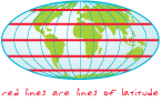
The latitude value that defines the center, and sometimes the origin, of a projection.
The latitude value that defines the origin of the y-coordinate values for a projection.
The visual representation of a geographic dataset in any digital map environment. Conceptually, a layer is a slice or stratum of the geographic reality in a particular area, and is more or less equivalent to a legend item on a paper map. On a road map, for example, roads, national parks, political boundaries, and rivers might be considered different layers.
In ArcGIS, a reference to a data source, such as a shapefile, coverage, geodatabase feature class, or raster, that defines how the data should be symbolized on a map. Layers can also define additional properties, such as which features from the data source are included. Layers can be stored in map documents (.mxd) or saved individually as layer files (.lyr). Layers are conceptually similar to themes in ArcView 3.x.
A special file (layer_name.lpk) that contains a layer, a copy of the data, and an XML file that has a brief description of the layer. It can be opened in ArcGIS Desktop (9.3.1 or later) and ArcGIS Explorer 900 using an automatic unpacking process called a "file handler". Layer packages are created in ArcMap (9.3.1 or later) or ArcGlobe (9.3.1 or later).
The arrangement of elements on a map, possibly including a title, legend, north arrow, scale bar, and geographic data.
In ArcMap and ArcReader, a view that shows the virtual page upon which geographic data and map elements, such as titles, legends, and scale bars, are placed and arranged for printing.
In MOLE, typically two or more force elements grouped together and placed on a line based on user-specified rules. Leaders are often used to clean up the map display in cases where many symbols overlap, to group related units together, and to define perimeters or areas of interest for formations.
See also force element, tactical graphic, stack.The path between two locations that costs the least to traverse, where cost is a function of time, distance, or some other criteria defined by the user.
See also cost, shortest path.A statistical method for providing a best fit for survey point locations and detecting measurement error by minimizing the sum of the squares of measurement residuals. The method allows many measurements to participate simultaneously in a single computation.
The final measurement residuals of a least squares adjustment.
See also least-squares adjustment.The topological data structure in an ArcInfo coverage that stores, for each arc, the identity of the polygons to the left and right of it. Left-right topology supports analysis functions, such as adjacency.
The description of the types of features included in a map, usually displayed in the map layout. Legends often use graphics of symbols or examples of features from the map with a written description of what each symbol or graphic represents.
An abstraction of a layer in ArcGlobe portraying the layer at some degree of resolution between simplified and unsimplified.
In ArcInfo, a collection of spatially related ArcStorm or Map Librarian layers. A library has a spatial extent that applies to all layers in the library.
Acronym for light detection and ranging. A remote-sensing technique that uses lasers to measure distances to reflective surfaces.

In Survey Analyst for field measurements, restrictions that define an acceptable level of measurement error for each computation.
On a map, a shape defined by a connected series of unique x,y coordinate pairs. A line may be straight or curved.
See also polyline.
A collection of states representing the changes that have occurred over time in a versioned geodatabase.
A measurement of the horizontal or vertical dimension of a feature. Linear dimensions may not represent the true distance between beginning and ending dimension points because they do not take angle into account as aligned dimensions do.
See also aligned dimension.
A method for storing geographic data by using a relative position along an already existing line feature; the ability to uniquely identify positions along lines without explicit x,y coordinates. In linear referencing, location is given in terms of a known line feature and a position, or measure, along the feature. Linear referencing is an intuitive way to associate multiple sets of attributes to portions of linear features.
See also dynamic segmentation.The unit of measurement on a plane or a projected coordinate system, often meters or feet.
See also angular unit, unit of measure.A procedure that combines groups of individual lines with the same name into a single line for the label engine. This is often necessary because lines such as roads and rivers are usually digitized as many small segments that must be connected together to represent a single real-world feature.
In linear referencing, a description of a portion of a route using a from- and to-measure value. Examples of line events include pavement quality, salmon spawning grounds, bus fares, pipe widths, and traffic volumes.
A line drawn between two points, an origin and a target, that is compared against a surface to show whether the target is visible from the origin and, if it is not visible, where the view is obstructed.
In a perspective view, the point and direction from which a viewer looks into an image.
In linear referencing, the overlay of two line event tables to produce a single line event table. The new event table can be the logical intersection or union of the input tables.
In linear referencing, the overlay of a line event table and a point event table to produce a single point event table. The new event table can be the logical intersection or union of the input tables.
In georeferencing, connections added between known points in a dataset being georeferenced and corresponding points in the dataset being used as a reference.
An operation that relates two tables using a common field, without altering either table.
In Survey Analyst for field measurements, an operation in which existing features can be connected to survey points. An association between survey points and feature vertices is created; feature locations are not updated automatically.
In Survey Analyst for field measurements, a command that finds nearby survey points for each feature vertex and automatically creates links. The command allows the user to specify the search tolerance for finding the survey points. With the Link command, users may perform batch links; it is useful to use if there are many unlinked features that need to be associated with nearby survey points.
In Survey Analyst for field measurements, lines displayed on a map after a survey point and a feature vertex are linked.
In Survey Analyst for field measurements, a tool that allows the user to make a link between a survey point and a feature vertex by snapping and clicking a feature vertex, then snapping to and clicking the related survey point. With the Link tool, users must make each individual link manually.
In Survey Analyst for field measurements, one of two types of pages in the Survey Explorer. The List page lists multiple survey objects.
The computation of an output raster where the output value at each location is a function of the input value at the same location.
See also global analysis, spatial function.In Survey Analyst for field measurements, one of two ways to apply the Coordinate Out of Tolerance command. The Local check method searches for coordinates out of tolerance within each survey project.
In ArcGIS Geostatistical Analyst, a deterministic interpolation method. The interpolated surface is not required to conform to the sample data points, and the method does not have standard errors associated with it.
See also interpolation.An identifier assigned to a region or feature.
The process of finding the best locations for one or more facilities that will service a given set of points and then assigning those points to the facilities, taking into account factors such as the number of facilities available, their cost, and the maximum impedance from a facility to a point.
See also cost, impedance.In Survey Analyst - Cadastral Editor, a parcel that has been locked for editing. Locked parcels cannot be edited simultaneously in a multiuser environment.
The power to which a fixed number (the base) must be raised to equal a given number. The three most frequently used bases for logarithms are base 10, base e, and base 2.
A database file that records changes in data, often used as part of a database restoration.
In an ArcSDE geodatabase, a table that maintains a list of the OBJECTIDs of selected records, allowing for faster analysis and processing of information.
A string of numbers, constants, variables, operators, and functions that returns a value of true or false.
An abstract representation of a network, implemented as a collection of hidden tables. A logical network contains edge, junction, and turn elements, the connectivity between them, and the weights necessary for traversing the network. It does not contain information about the geometry or location of its elements; this information is one of the components of a network system.
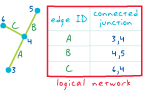
An operator used to compare logical expressions that returns a result of true or false. Examples of logical operators include less than (<), greater than (>), equal to (=), and not equal to (<>).
See also operator, logical expression.The angular distance, usually expressed in degrees, minutes, and seconds, of the location of a point on the earth's surface east or west of an arbitrarily defined meridian (usually the Greenwich prime meridian). All lines of longitude are great circles that intersect the equator and pass through the North and South Poles.
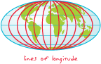
The longitude value that defines the center, and sometimes the origin, of a projection.
The longitude value that defines the origin of the x-coordinate values for a projection.
In a spatial model, coarse-scale variation that is usually modeled as the trend.
See also trend.An edit session on a feature dataset that may last from a few minutes to several months. Long transactions are managed by the ArcSDE versioning mechanism.
A replication model that does not require the parent and child replicas to be directly connected for synchronization to occur. Loosely coupled replication is an asynchronous model, so edits made in one replica have no effect on other related replicas until synchronization. Synchronization can be executed manually, or it can be automated.
See also replication.Data compression that has the ability to store data without changing any of the values, but is only able to compress the data at a low ratio (typically 2:1 or 3:1). In GIS, lossless compression is often used to compress raster data when the pixel values of the raster will be used for analysis or deriving other data products.
See also lossy compression.Data compression that provides high compression ratios (for example 10:1 to 100:1), but does not retain all the information in the data. In GIS, lossy compression is used to compress raster datasets that will be used as background images, but is not suitable for raster datasets used for analysis or deriving other data products.
See also lossless compression.A computer program, usually a text file, containing a sequence of commands that are executed as a single command. Macros are used to perform commonly used sequences of commands or complex operations.
A secondary window in ArcMap data view that shows a magnified view of a small area without changing the map extent. Moving the Magnifier window around will not affect the current map display.
The longer axis of an ellipse or spheroid.
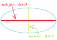
A technique for resampling raster data in which the value of each cell in an output is calculated, most commonly using a 2x2 neighborhood of the input raster. Majority resampling does not create any new cell values, so it is useful for resampling categorical or integer data, such as land use, soil, or forest type. Majority resampling acts as a type of low-pass filter for discrete data, generalizing the data and filtering out anomalous data values.
See also resampling.In ArcGIS Spatial Analyst, an option that creates a permanent raster (one that is saved to disk) from a temporary result.
A raster catalog in which the raster datasets are copied to a location assigned by a geodatabase. When a row is deleted from a managed raster catalog, the data is deleted as well.
See also unmanaged raster catalog.A graphic representation of the spatial relationships of entities within an area.
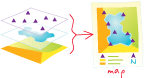
Any graphical representation of geographic or spatial information.
The document used in ArcMap to display and work with geographic data. In ArcMap, a map contains one or more layers of geographic data, contained in data frames, and various supporting map elements, such as a scale bar.
A language that defines a syntax for combining map themes by applying mathematical operations and analytical functions to create new map themes. In a map algebra expression, the operators are a combination of mathematical, logical, or Boolean operators (+, >, AND, tan, and so on), and spatial analysis functions (slope, shortest path, spline, and so on), and the operands are spatial data and numbers.
In ArcGIS, text or graphics stored within the map data frame in an annotation group. Map annotation may be manually entered or generated from labels, and can be individually selected, positioned, and modified.
See also annotation, annotation group, annotation target, graphic text, label.A setting used in ArcMap that allows temporary storage of geodatabase or ArcIMS feature service features from a given map extent in the desktop computer's RAM, which may result in performance improvements in ArcMap for editing, feature rendering, and labeling.
A graphic representation of a map on a computer screen.
In ArcMap, the file that contains one map, its layout, and its associated layers, tables, charts, and reports. Map documents can be printed or embedded in other documents. Map document files have a .mxd extension.
In digital cartography, a distinctly identifiable graphic or object in the map or page layout. For example, a map element can be a title, scale bar, legend, or other map-surround element. The map area itself can be considered a map element; or an object within the map can be referred to as a map element, such as a roads layer or a school symbol.
In ArcInfo Workstation Map Librarian, a collection of geographic data partitioned spatially as a set of tiles and thematically as a set of layers, indexed by location for rapid access.
A collection of maps usually addressing a particular theme.
A type of Web service that generates maps.
See also Web service.Any of the supporting objects or elements that help a reader interpret a map. Typical map surround elements include the title, legend, north arrow, scale bar, border, source information and other text, and inset maps.
See also map element.
In ArcMap, a kind of map document that provides a quick way to create a new map. Templates can contain data, a custom interface, and a predefined layout that arranges map elements, such as north arrows, scale bars, and logos, on the virtual page. Map templates have a .mxt file extension.
In ArcGIS, a user-assistance component that displays an on-screen description of a map feature when the mouse is paused over that feature.
A temporary set of topological relationships between coincident parts of simple features on a map, used to edit shared parts of multiple features.
The ground unit of measurement—for example, feet, miles, meters, or kilometers—in which coordinates of spatial data are stored.
A geographic zone containing the people who are likely to purchase a firm's goods or services.
A process that determines the percentage of a market area being reached based on the number of customers within an area divided by the total population in that area.
In digital cartography, a means of covering or hiding features on a map to enhance cartographic representation. For example, masking is often used to cover features behind text to make the text more readable.
In ArcGIS, a means of identifying areas to be included in analysis. Such a mask is often referred to as an analysis mask, and may be either a raster or feature layer.
In ArcGIS 9.1 and previous versions, the data version in the master geodatabase, created when data is checked out, that represents the state of the data at the time it was checked out.
In ArcGIS 9.1 and previous versions, a geodatabase from which data has been checked out.
In Business Analyst, the site of a known, well-performing business.
In geocoding, the process of linking a record, such as an address, to a set of reference data. The matched record in the reference data is used to determine the location of the input address.
See also geocoding, reference data.In geocoding, a value assigned to all potential candidates for an address match. The match score is based on how well the location found in the reference data matches with the address data being searched.
A kind of expression that evaluates to a number which is then typically stored in a variable, a field on a table row, or a cell in a raster dataset. Mathematical expressions are generally part of an algebraic equation:
Result = Expression
[PropertyTax] = ( [LandValue] * 0.75 ) + ( [StructureValue] * 0.50 )
In ArcGIS Spatial Analyst, a function that applies a mathematical operation to the values of a single input raster. There are four groups of mathematical functions available: logarithmic, arithmetic, trigonometric, and powers.
In Survey Analyst for field measurements, a set of relations between measurements and unknown coordinates.
The average for a set of values, computed as the sum of all values divided by the number of values in the set.
The location of a single x,y coordinate value that represents the average x-coordinate value and the average y-coordinate value of all features in a study area.
In geostatistics, a property of a spatial process in which a spatial random variable has the same mean value at all locations.
See also stationarity.In linear referencing, either one or two fields in a table that describe the position of an event along a route.
An observed numerical value that is an appraisal of size, extent, or amount according to a set criteria.
In surveying, the noise that is expected in every measurement. It occurs because the observer makes estimates and uses measuring equipment that is unpredictable in an environment that is also unpredictable.
The difference between a measured quantity and its theoretical true value as determined during each iteration of a least-squares adjustment.
A location representing the shortest total distance to all other features in a study area.
See also mean, mean center.In ArcGIS Online, ArcGIS users who have registered for ArcGIS Online. Members can also belong to groups.
See also group.A list of available commands or operations displayed on a computer screen from which a user can make a selection.
An item in a list of commands displayed on a menu.
In geodatabases, rules that dictate what happens to the respective attributes of features that are merged together during editing in ArcMap. A merge policy can be set to assign a default value to the new attribute, summarize the values of the merged attributes, or create a weighted average from the merged attributes.
Combining features from multiple data sources of the same data type into a single, new dataset.
See also appending.A great circle on the earth that passes through the poles, often used synonymously with longitude. Meridians run north–south between the poles. By convention, meridians are labeled with positive numbers that ascend as one moves eastward from the prime meridian, and negative numbers as one moves westward from the prime meridian until the east and west hemispheres meet at the 180-degree line. Meridians can also, however, be labeled with all positive or negative numbers, including positive numbers increasing westward from the prime meridian.
Information that describes the content, quality, condition, origin, and other characteristics of data or other pieces of information. Metadata for spatial data may describe and document its subject matter; how, when, where, and by whom the data was collected; availability and distribution information; its projection, scale, resolution, and accuracy; and its reliability with regard to some standard. Metadata consists of properties and documentation. Properties are derived from the data source (for example, the coordinate system and projection of the data), while documentation is entered by a person (for example, keywords used to describe the data).
A unit of information within metadata, used to describe a particular characteristic of the data.
A modification of an existing metadata standard to adapt to data issues, cultural issues, or both. A profile is typically a subset of a base standard that tailors the metadata elements in the base standard to better describe the data to the community that uses it. Metadata profiles allow communities to follow a metadata standard, while at the same time enhancing the standard so that it is more appropriate for a particular use or locale.
In object-oriented programming, an action that an object is capable of performing. Objects that belong to the same class all have the same methods. For example, all Visual Basic form objects can execute a method called "Show and Hide."
A geographic entity defined by the U.S. Office of Management and Budget for use by federal statistical agencies, including the U.S. Census Bureau. A metropolitan statistical area is based on the concept of a core area with a large population nucleus, plus adjacent communities having a high degree of economic and social integration with that core area. According to the 1990 standards, to qualify as a metropolitan statistical area, the area must include at least one city or urbanized area with 50,000 or more inhabitants and a total metropolitan population of at least 100,000 (75,000 in New England).
An ArcGIS extension that optimizes the effectiveness of core ArcGIS as a toolset foundation for military planners and intelligence analysts. Military Analyst is COM-compliant and extensible with ArcObjects.
See also MOLE.The military specification for common war fighting symbology; the U.S. military standard that provides guidelines and criteria for the development and display of standard C4I war fighting symbology.
A rectangle, oriented to the x- and y-axes, that bounds a geographic feature or a geographic dataset. It is specified by two coordinate pairs: xmin, ymin and xmax, ymax.
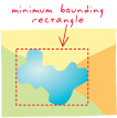
In geocoding, the minimum score a potential match record requires to be considered a candidate. This value is adjustable on the Address Locator Properties dialog box.
For a given scale, the size in map units below which a narrow feature can be reasonably represented by a line and an area by a point.
See also map unit.In geocoding, the minimum score a match candidate needs to be considered a match in batch geocoding. This value is adjustable on the Address Locator Properties dialog box.
The shorter axis of an ellipse or spheroid.
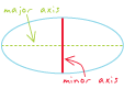
In Survey Analyst for field measurements, one of two types of lists in the List page. The mixed list has a mixed set of rows that might have, for instance, survey points, coordinate geometry measurements, and a mix of different computations.
A set of rules and procedures for representing a phenomenon or predicting an outcome.
A data representation of reality, such as the vector data model.
In geoprocessing in ArcGIS, one process or a sequence of processes connected together, that is created in ModelBuilder.
The interface used to build and edit geoprocessing models in ArcGIS.
In ArcGIS, a type of parameter exposed in a geoprocessing model that displays in a model's dialog box and allows for input.
In MOLE, text or graphics that display around a symbol, or a value that changes the appearance of a symbol. In some military specifications, attributes are referred to as modifiers.
See also attribute.Acronym for Military Overlay Editor. An ESRI software application that allows users to create, display, and edit military symbology in their maps.
A raster dataset composed of two or more merged raster datasets—for example, one image created by merging several individual images or photographs of adjacent areas.
Maps of adjacent areas with the same spatial reference and scale whose boundaries have been matched and dissolved.
A way of using a digitizing tablet in which the digitizer puck behaves like a mouse; the puck is used to point to interface elements rather than to trace shapes on the surface of the digitizing tablet.
Acronym for Map Production System. The cartographic component of the Production Line Tool Set (PLTS). MPS is designed to facilitate large-volume cartographic production by providing the ability to create dynamic map layouts, batch symbology, and enhanced cartographic editing tools.
Data that is comprised of multiple dimensions, such as space and time. For example, a temperature dataset could have dimensions of latitude, longitude, altitude, and time.
See also dimension.A network in which two or more types of transportation modes (such as walking, riding a train, or driving a car) are modeled. In a network dataset, multiple connectivity groups are required to create a multimodal network.
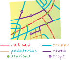
In ArcGIS, a digital representation of a place or thing that has more than one part but is defined as one feature because it references one set of attributes. In a layer of states, for example, the state of Hawaii could be considered a multipart feature because its separate geometric parts are classified as a single state. A multipart feature can be a point, line, or polygon.
See also feature.
In ArcGIS, a type of geometry comprised of planar three-dimensional rings and triangles, used in combination to model objects that occupy discrete area or volume in three-dimensional space. Multipatches may represent geometric objects like spheres and cubes, or real-world objects like buildings and trees.
In the Survey Analyst for field measurements Survey Explorer, one of two types of setup pages. The Multiple Setup page is used for computations that process more than one instrument setup.
In ArcGIS software, a digital map feature that represents a place or thing that has neither area nor length at a given scale, and that is treated as a single object with multiple locations. For example, the entrances and exits to a prairie dog den might be represented as a multipoint feature. A multipoint feature is associated with a single record in an attribute table.
See also feature.
A feature class that can store many points per shape or row, thereby saving storage space and improving read-write performance.
See also feature class, multipoint feature.Related to two or more frequencies or wavelengths in the electromagnetic spectrum.
An image created from several narrow spectral bands.
See also multispectral.
A geodatabase managed in an RDBMS server by ArcSDE. Multiuser geodatabases can be very large and support multiple concurrent editors. They are supported on a variety of commercial RDBMS, including IBM DB2, IBM Informix, Oracle, Microsoft SQL Server, and PostgreSQL.
In ArcGIS and ArcSDE, a view that uses stored procedures and triggers to access a specified version of data in a single business table in the geodatabase. A multiversioned view includes all the records in the business table that have been selected and merged with records from the delta tables. The schema of a multiversioned view is identical to that of the business table on which it is based.
See also view.In linear referencing, a measure value that is added to a line feature. M-values are used to measure the distance along a line feature from a vertex (a known location) to an event.
Vertex attributes that are stored with x,y point coordinates in ESRI's Geometry Engine. Every type of geometry (point, polyline, polygon, and so on) can have attributes for every vertex.
A computer file that contains all the work done in Business Analyst: study areas; analyses; and customer, store, and extracted data.
In ArcCatalog, a folder that contains nonsystem toolboxes created in the ArcToolbox window or directly in the My Toolboxes folder in the ArcCatalog Tree. The My Toolboxes folder points to a location on disk that can be changed in the Geoprocessing tab of the Options dialog box, accessible from the Tools menu.
Acronym for North American Datum of 1927. The primary local horizontal geodetic datum and geographic coordinate system used to map the United States during the middle part of the twentieth century. NAD 1927 is referenced to the Clarke spheroid of 1866 and an origin point at Meades Ranch, Kansas. Features on USGS topographic maps, including the corners of 7.5-minute quadrangle maps, are referenced to NAD27. It is gradually being replaced by the North American Datum of 1983.
Acronym for North American Datum of 1983. A geocentric datum and graphic coordinate system based on the Geodetic Reference System 1980 ellipsoid (GRS80). Mainly used in North America, its measurements are obtained from both terrestrial and satellite data.
See also NAD 1927, geocentric datum.Acronym for not a number.
A method of manual data classification that seeks to partition data into classes based on natural groups in the data distribution. Natural breaks occur in the histogram at the low points of valleys. Breaks are assigned in the order of the size of the valleys, with the largest valley being assigned the first natural break.
See also classification.An interpolation method for multivariate data in a Delaunay triangulation. The value for an interpolation point is estimated using weighted values of the closest surrounding points in the triangulation. These points, the natural neighbors, are the ones the interpolation point would connect to if inserted into the triangulation.
See also interpolation.
To interactively change the observer's or target's position using a tool designed for this purpose, such as the navigate or fly tool. There are three contexts in which a user can navigate: in a scene of ArcScene, in a preview of ArcCatalog, and in a globe of ArcGlobe.
A technique for resampling raster data in which the value of each cell in an output raster is calculated using the value of the nearest cell in an input raster. Nearest neighbor assignment does not change any of the values of cells from the input layer; for this reason it is often used to resample categorical or integer data (for example, land use, soil, or forest type), or radiometric values, such as those from remotely sensed images.
The border delineating and defining the extent of geographic data on a map. It demarcates map units so that, depending on the map projection, the neatline does not always have 90-degree corners. In a properly made map, it is the most accurate element of the data; other map features may be moved slightly or exaggerated for generalization or readability, but the neatline is never adjusted.

Methods of defining new values for locations using the values of other locations within a given distance or direction.
See also nearest neighbor resampling, natural neighbors.An interconnected set of points and lines that represent possible routes from one location to another. For geometric networks, this consists of edge features, junction features, and the connectivity between them. For network datasets, this consists of edge, junction, and turn elements and the connectivity between them. For example, an interconnected set of lines representing a city streets layer is a network.
See also geometric network, logical network, network dataset, physical network.Any method of solving network problems such as traversability, rate of flow, or capacity, using network connectivity.
See also network.In ArcGIS Network Analyst, a feature class or table containing network analysis objects that is stored within a network analysis layer. Network Analyst solvers read input from, and write output to, network analysis classes.
A composite layer that contains the properties and network analysis classes used in the analysis of a network problem, and the results of the analysis.
See also layer, network layer.In ArcGIS Network Analyst, a feature or row in a network analysis class. Network analysis objects are used as input and written as output during network analysis. A network location is a specific type of network analysis object that has a defined position on a network dataset.
An auxiliary or additional function performed by a junction feature within a geometric network. Junction features can act as sources or sinks for calculating flow direction. If a junction is a source or a sink, it is said to have an ancillary role in the network.
A type of attribute associated with a network element in a network dataset. Network attributes are used to help control flow through a network (similar to a weight in a geometric network). All network elements in a network dataset have the same set of attributes. There are four types of network attributes: cost, descriptor, hierarchy, and restriction.
See also attribute, cost, descriptor, hierarchy, restriction.A collection of topologically connected network elements (edges, junctions, and turns) that are derived from network sources, typically used to represent a linear network, such as a road or subway system. Each network element is associated with a collection of network attributes. Network datasets are typically used to model undirected flow systems.
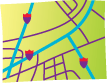
A component in a network dataset: an edge, junction, or turn. All elements in a network dataset share the same set of network attributes. Network elements are used to model topological relationships in undirected flow networks such as traffic flow systems. Network elements are generated from point, line, and turn features. When the network dataset is built, point features become junctions, line features become edges, and turn features become turn elements.
See also network feature.A component in a geometric network: an edge or a junction. Features in a geometric network are used to model topological relationships, typically in directed flow networks such as hydrologic or utility systems. Network features are generated from points and lines when the geometric network is built: point features become junctions, and line features become edges.
A layer that references a network dataset. In a geodatabase, a network dataset is a collection of network elements (edges, junctions and turns) that are derived from network sources.
See also layer, network dataset, network analysis layer.A geographic position in a network system.
In ArcGIS Network Analyst, a type of network analysis object that is zero-dimensional and has a defined position on a network dataset. It can be used during a network analysis operation, such as delivery stops for a route analysis. There are eight types of network locations: stops, barriers, facilities, incidents, origins, destinations, orders and depots.
A connecting point in a geometric network, such as an intersection or interchange of a road network, confluence of streams in a hydrologic network, or switch in a power grid.
A number that is used to specify direct communication over a network to an Internet application.
Feature classes in a geodatabase that are used to generate and define a network dataset.
See also network dataset, network element.A function that performs network analysis on a geometric network. Specific kinds of network tracing include finding features that are connected, finding common ancestors, finding loops, tracing upstream, and tracing downstream.
A process that finds a potential location for a new store by calculating the centroid of a group of customers.
Acronym for National Marine and Electronics Association. A nonprofit association composed of manufacturers, distributors, dealers, educational institutions, and others interested in peripheral marine electronics occupations. The NMEA has created a standard that defines an electrical interface and data protocol for communications between marine instrumentation that has been adopted as an industry standard by the GPS industry.
In raster data, the absence of a recorded value. NoData does not equate to a zero value. While the measure of a particular attribute in a cell may be zero, a NoData value indicates that no measurements have been taken for that cell at all.
See also null value.In a geodatabase, the point representing the beginning or ending point of an edge, topologically linked to all the edges that meet there.
In a coverage, the beginning or ending point of an arc, topologically linked to all the arcs that meet there.
In a TIN, one of the three corner points of a triangle, topologically linked to all triangles that meet there. Each sample point in a TIN becomes a node in the triangulation that may store elevation z-values and tag values.
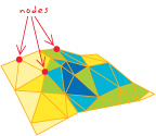
In graph theory, any vertex in a graph.
The point at which a computer, or other addressable device, attaches to a communications network.
In remote sensing, any disturbance in a frequency band.
Any irregular, sporadic, or random oscillation in a transmission signal.
Random or repetitive events that interfere with communication.
In a raster, irrelevant or meaningless cells that exist due to poor scanning or imperfections in the original source document.
The process of dividing one numeric attribute value by another to minimize differences in values based on the size of areas or the number of features in each area. For example, normalizing (dividing) total population by total area yields population per unit area, or density.
The template that is automatically loaded in ArcMap and contains all the standard toolbar and command default settings. User interface customization that is saved in the Normal template is loaded each time ArcMap is launched.
A map symbol that shows the direction of north on the map, thereby showing how the map is oriented.
Acronym for Notice to Airmen. An advisory bulletin containing information about the National Airspace System, typically time-sensitive information between publishing cycles, or corrections to published documents and charts.
In ArcGIS Online, status message about your group membership request.
Acronym for National Spatial Data Infrastructure. A federally mandated framework of spatial data that refers to U.S. locations, as well as the means of distributing and using that data effectively. Developed and coordinated by the FGDC, the NSDI encompasses policies, standards, procedures, technology, and human resources for organizations to cooperatively produce and share geographic data. The NSDI is developed by the federal governments; state, local, and tribal governments; the academic community; and the private sector.
See also FGDC.A community of digital spatial data providers that maintain NSDI Clearinghouse Nodes as part of the U.S. National Spatial Data Infrastructure.
An Internet server that hosts a collection of metadata and data maintained and stored on a computer server by a data provider. An NSDI Clearinghouse Node provides information about geographic data within the data provider's areas of responsibility. Nodes must host FGDC-compliant metadata and data and use a common access protocol.
See also NSDI Clearinghouse Network.Acronym for Notice to Mariners. A periodical update to existing nautical charts, issued by maritime authorities.
A parameter of a covariance or semivariogram model that represents independent error, measurement error, or microscale variation at spatial scales that are too fine to detect. The nugget effect is seen as a discontinuity at the origin of either the covariance or semivariogram model.
A DBMS-defined restriction specifying that a column cannot contain a null value.
See also null value.The absence of a recorded value for a field. A null value differs from a value of zero in that zero may represent the measure of an attribute, while a null value indicates that no measurement has been taken.
In GIS, a digital representation of a spatial or nonspatial entity. Objects usually belong to a class of objects with common attribute values and behaviors.
In computing, a piece of software that performs a specific task and is controlled by another piece of software, called a client. For example, an object is often the interface by which an application program accesses an operating system and other services.
In ArcMap, ArcScene, or ArcGlobe, the camera, view, table or layer to which an animation track is attached.
In a geodatabase, a collection of nonspatial data of the same type or class. While spatial objects (features) are stored in feature classes in a geodatabase, nonspatial objects are stored in object classes.
A table in a geodatabase used to store a collection of objects with similar attributes and behavior. Objects with no locational information are stored as rows or records in object classes. Spatial objects, or features, are stored as rows in feature classes, which are a specialized type of object class in which objects have an extra attribute to define their geographic location.
In ArcGIS, a system-managed value that uniquely identifies a record or feature.
An ellipsoid created by rotating an ellipse around its minor axis. The shape of the earth approximates an oblate ellipsoid with a flattening ratio of 1 to 298.257.
See also prolate ellipsoid, ellipsoid, spheroid.
A planar or cylindrical projection whose point of tangency is neither on the equator nor at a pole.

A conic projection whose axis does not line up with the polar axis of the globe.
A cylindrical projection whose lines of tangency or secancy follow neither the equator nor a meridian.
In ArcGIS, a change in or the act of changing the z-value for a surface or features in a scene by a constant amount or by using an expression. Offsets may be applied to make features draw just above a surface.
Acronym for Open Geospatial Consortium. An international consortium of companies, government agencies, and universities participating in a consensus process to develop publicly available geospatial and location-based services. Interfaces and protocols defined by OpenGIS specifications support interoperability and seek to integrate geospatial technologies with wireless and location-based services.
Object Linking and Embedding database provider. A tool conforming to the OLE standard for sharing data between applications. Each OLE DB provider communicates with and retrieves data from a different database, but a user can work with the data retrieved by any OLE DB provider in a similar way.
A type of geodatabase replication that allows data changes to be sent multiple times from the parent replica to the child replica. In a one-way replication, the data in the parent replica is editable, and the data in the child replica is read-only. During synchronization, edits are applied directly to the child replica so that no conflicts occur. ArcSDE geodatabases are used to create one-way replicas.
See also replica, parent replica, child replica.Assembled, created, presented, or calculated dynamically during a transaction such as a Web page search or data display query.
In surveying, a traverse that does not close back upon itself or on another point of known position. As such, it does not provide a means of checking for errors.
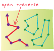
A data value or the symbolic representation of a data value in an expression. Operands may be numbers, character strings, functions, variables, parenthetical expressions in the body of a larger expression, and so on. Symbolic representations of operands, such as variables and functions, are evaluated before they are operated upon by the operators in the expression. For example, in the expression "1 + 2", the operands are 1 and 2, and are operated upon by the + (plus) operator, which adds the operands together and returns the value 3.
In surveying, an alphanumeric or numeric value included in an instrument vendor's data collector file format. Operation codes are used to describe such elements as new instrument setups and numeric values for horizontal angles, zenith angles, slope distance measurements, height of instrument, and height of target. These basic operation codes are supported in Survey Analyst for field measurements for the following formats: Geoserial Interface (GSI), TDS raw, TDS coordinate, Geodimeter, and Sokkia SDR.
The symbolic representation of a process or operation performed against one or more operands in an expression, such as "+" (plus, or addition) and ">" (greater than). When evaluated, operators return a value as their result. If multiple operators appear in an expression, they are evaluated in order of their operator precedence.
See also operator precedence, operand.The order in which operators are evaluated in an expression; operators with a higher precedence are evaluated before those with a lower precedence. If all operators in an expression have the same precedence, they are evaluated in the order in which they appear, from left to right. Parentheses may be used to override operator precedence; portions of an expression within parenthesis are evaluated first, and parenthetical expressions may be nested.
See also operator, operand.A database company that produces a relational database management system (also called Oracle), which allows data and other objects to be stored in tables. Oracle provides client/server access to data and uses indexes, sequences, and other database objects to facilitate rapid data creation, editing, and access. ESRI uses Oracle's RDBMS to store vector and raster data for use by ArcSDE.
In ArcGIS Network Analyst, a network location used to determine routes in vehicle routing problem (VRP) analysis. Users can specify multiple orders. Orders may represent any combination of service locations or pickup/delivery locations to be visited along a route.
In ArcGIS Network Analyst, an object used in vehicle routing problem (VRP) analysis. An order pair defines a relationship between two orders. The first order in the order pair represents a pickup which must then be delivered to the second order in the order pair on the same route.
An object's position or relationship in direction with reference to points of the compass.
In Survey Analyst for field measurements, the method by which horizontal angle readings for TPS measurements are converted into azimuths.
An option that controls whether a label can be placed in an upside-down or sideways position. A small angle prevents labels from switching their reading order in the labeling of nearly vertical lines.
A fixed reference point in a coordinate system from which all other points are calculated, usually represented by the coordinates (0,0) in a planar coordinate system and (0,0,0) in a three-dimensional system. The center of a projection is not always its origin.
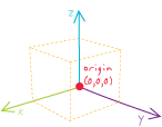
The primary object in a relationship, such as a feature class containing points where measurements are taken. The measurements are stored in another table.
In a network in ArcInfo Workstation, the beginning of a path.
In ArcGIS Network Analyst, a network location used in origin-destination cost matrix analysis that specifies a starting location.
In ArcGIS Network Analyst, a type of network analysis that computes a table containing the total impedance from each origin to each destination. Additionally, it ranks the destinations that each origin connects to in ascending order of the time it takes to travel from that origin to each destination.
See also origin, destination.
Intersecting at right angles.
A line that is perpendicular to another line at its point of tangency, often used to measure distance from a line to a separate point that does not lie along the original line.

A planar projection, tangent to the earth at one point, that views the earth's surface from a point approaching infinity, as if from deep space.

In 3D Analyst, a perspective that allows viewing of data in a scene as a two-dimensional plane seen from above. There is no perspective foreshortening in orthographic view, so scale is constant across the entire display.
An aerial photograph from which distortions owing to camera tilt and ground relief have been removed. An orthophotograph has the same scale throughout and can be used as a map.
See also aerial photograph.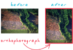
The process of correcting the geometry of an image so that it appears as though each pixel were acquired from directly overhead. Orthorectification uses elevation data to correct terrain distortion in aerial or satellite imagery.
See also rectification, geometric correction.An unusual or extreme data value in a dataset. In data analysis, outliers can potentially have a strong effect on results and so must be analyzed carefully to determine if they represent valid or erroneous data.
In geology, a feature that lies apart from the main body or mass to which it belongs: for example, a rock or stratum that has been separated from a formation by erosion.
A vectorization method that generates lines along the borders of connected cells. It is typically used for vectorizing scanned land-use and vegetation maps.
Data that is the result of a computer, device, program, or process.
See also input data, intermediate data.A list of labels that could not be placed, generated during the process of converting labels to annotation. This list allows the manual placement or deletion of these labels.
A method of defining the rings in an analysis so that the values inside the rings are cumulative. For example, if you had an analysis with three concentric rings and 10 households in each, the total number of households for ring 1 would be 10, the total for ring 2 would be 20 (ring 1 + ring 2), and the total for ring 3 would be 30 (ring 1 + ring 2 + ring 3).
A spatial operation in which two or more maps or layers registered to a common coordinate system are superimposed, either digitally or on a transparent material, for the purpose of showing the relationships between features that occupy the same geographic space.
In geoprocessing, the geometric intersection of multiple datasets to combine, erase, modify, or update features in a new output dataset.
In ArcGIS 8.3 and previous versions, an ArcToolbox wizard that uses overlay operations to create a new coverage by computing the geometric intersection of two coverages: an input coverage and an overlay coverage.
In network datasets, a type of junction connectivity policy in which the way junctions connect to other junctions is not based on the existing edge connectivity policy; junctions "override" the edge connectivity policy.
In ArcGIS, an exception made to a property of a feature representation’s representation rule so that the feature is drawn differently than others sharing the same rule.
The portion of an arc digitized past its intersection with another arc.
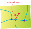
Coarsest representation of the terrain dataset, intended for fast drawing at small scales.
A secondary window in ArcMap data view that shows the full extent of the data, without changing the map extent. A red box in the window represents the current map extent.
In ArcGIS Online, the person responsible for creating and managing an item of content or a group. The owner determines who has access to the content or group.
See also group.In Survey Analyst - Cadastral Editor, an XML stream or file containing the portion of the cadastral fabric that has been extracted by a cadastral fabric job for editing.
To shift a map image relative to the display window without changing the viewing scale.
Sensitive to light of all wavelengths in the visible spectrum.
A single band image generally displayed as shades of gray.
See also panchromatic.An imaginary east–west line encircling the earth, parallel to the equator and connecting all points of equal latitude. Also, the representation of this line on a globe or map.
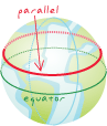
One of the variables that define a specific instance of a map projection or a coordinate system. Parameters differ for each projection and can include central meridian, standard parallel, scale factor, or latitude of origin.
A variable that determines the outcome of a function or operation.
In geoprocessing in ArcGIS, a characteristic of a tool. Values set for parameters define a tool's behavior during run time.
A curve that is defined mathematically rather than by a series of connected vertices. A parametric curve has only two vertices, one at each end.
See also Bezier curve.A piece or unit of land, defined by a series of measured straight or curved lines that connect to form a polygon.
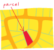
In Survey Analyst - Cadastral Editor, a group of point, line and polygon features in the cadastral fabric that contain information such as dimensions on the line features, area on the polygon features and other administrative data. Parcels may be used to model lots, blocks, and many other land units.
In Survey Analyst - Cadastral Editor, a set of dimensions entered to create a set construction line work.
See also construction line.In Survey Analyst - Cadastral Editor, a set of parcels that exist as a group instead of individually in a cadastral fabric job.
See also unjoined parcel.Acronym for parcel identification number. In Survey Analyst - Cadastral Editor, a unique identifier for a parcel. The format of an identifier is defined by the government's organization, and may contain numerical values, alpha characters, or both.
A classification for parcels, used to provide additional information about them and how they must be treated for least squares adjustment. Standard parcels, blocks, and easements are all examples of parcel types.
In geodatabase editing, data in a source geodatabase that is replicated.
See also replica.A parameter of a covariance or semivariogram model that represents the variance of a spatially autocorrelated process without any nugget effect. In the semivariogram model, the partial sill is the difference between the nugget and the sill.
See also sill, nugget. A string of characters that a user must enter to access a computer, program, database, or Web site. Passwords are a means of protecting and restricting access to information contained on networks, systems, or files.
A single triangular face inside a multipatch geometry. In most cases, many patches (faces) are used together to create a complex 3D model. Examples include geometric shapes, such as spheres, cubes, and tubes; geographic features, such as buildings, cars, and light poles; and other boundary representations, such as isosurfaces, used to represent geologic structures or environmental plumes. Patches in a multipatch geometry may or may not include an image (texture) displayed on them.
In computing, the location of a computer file, given as the drive, directories, subdirectories, and file name, in that order.
In ArcGIS software, a geometric element from which polylines and polygons are constructed. A path is a sequence of connected, nonintersecting segments, with no two segments having the same start point or the same endpoint.
In ArcMap, ArcScene, and ArcGlobe, a single line feature or graphic used to define the movement of a camera, view or layer in an animation.
In ArcGIS Spatial Analyst, a description of each cell's least accumulative cost relationship to a source or a set of sources, accounting for surface distance, horizontal cost factors and vertical cost factors.
A label that describes the nature of the association between the objects in a relationship. The forward path label describes the relationship when navigating from the origin to the destination; for example, station points "have" measurements. The backward path label describes the same relationship navigating from the destination to the origin, which might be "are taken at" in this example; measurements "are taken at" stations.
A measurement of the rate of change of elevation over a given horizontal distance, in which the rise is divided by the run and then multiplied by one hundred. A 45-degree slope and a 100-percent slope are the same.
A dataset permanently stored on disk.
A geodatabase that stores data in Microsoft Access. A personal geodatabase can be read simultaneously by several users, but only one user at a time can edit the same data.
A projection mode in 3D applications that allows viewing from a perspective that can be controlled by navigating the scene or globe from a specified location.
One of the two parts of a network system; the actual feature classes that participate in a network system.
See also network.
In ArcGlobe, anchoring a vector graphic element to the underlying globe surface so that it remains fixed.
The smallest unit of information in an image or raster map, usually square or rectangular. Pixel is often used synonymously with cell.
In remote sensing, the fundamental unit of data collection. A pixel is represented in a remotely sensed image as a cell in an array of data values.
The smallest element of a display device, such as a video monitor, that can be independently assigned attributes, such as color and intensity. Pixel is an abbreviation for picture element.
The dimensions on the ground of a single pixel in a raster, measured in map units. Pixel size is often used synonymously with cell size.
The formal or common name of a location, such as the name of a school, hospital, or other landmark. For example, "Memorial Hospital" is the place name for the address "893 Memorial Drive." In geocoding, the address locator can be set to accommodate the use of place-name aliases in place of their addresses for matching.
In surveying, a high-level organization of parcels; a survey document containing data from a recorded subdivision survey plan, or from a legal description. Often, many parcels are defined in one plan. In the Survey Analyst - Cadastral Editor cadastral fabric, plans hold such information about the subdivision plan record as the date, surveyor, entry units, scale factor, and so on. Each parcel contains a reference to a plan.
A two-dimensional measurement system that locates features on a plane based on their distance from an origin (0,0) along two perpendicular axes.
The process of creating multiple line features by splitting longer features at the places where they intersect other line features. This process is often applied to nontopological line work that has been spaghetti digitized or imported from a CAD drawing.
See also spaghetti data.A projection that transforms points from a spheroid or sphere onto a tangent or secant plane. Because its directions are often true, the planar projection is also known as an azimuthal or zenithal projection.
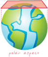
Two-dimensional; showing no relief.
A map that displays only the x,y locations of features and represents only horizontal distances.
See also topographic map.
The time mode in which data is displayed using the ArcGIS Tracking Analyst Playback Manager, replaying either real-time or fixed-time data.
The span of time defined by the Start and End text boxes in the ArcGIS Tracking Analyst Playback Manager. This window can be set to include the temporal extent of one or more layers.
Acronym for Production Line Tool Set. A software package that allows users to prepare and maintain data for maps, perform quality assurance/quality control tasks, and create map sheets. Its base product, PLTS Foundation, is composed of three parts: Foundation Tools, GIS Data ReViewer, and Map Production System and MPS-Atlas. The tools can be used with different product specifications, and are available as solutions that have been created for nautical, defense, aeronautical, and mapping agencies.
A tool used to batch load a personal or enterprise geodatabase from a variety of sources (coverages, shapefiles, or geodatabases). The PLTS data loader uses a cross-reference database to map the input schema to the output schema.
In PLTS, a tool for managing layer representation, such as symbology and label expressions.
A geometric element defined by a pair of x,y coordinates.
See also point feature.In Survey Analyst, part of the validation of survey data. This type of analysis is used to authenticate the relationships between survey points, coordinates, and the physical locations they represent.
In linear referencing, a feature that occurs at a precise point location along a route and uses a single measure value. Examples include accident locations along highways, signals along rail lines, bus stops along bus routes, and pumping stations along pipelines.
A map feature that has neither length nor area at a given scale, such as a city on a world map or a building on a city map.
See also feature.A field in the Survey Analyst Survey Explorer dialog box that allows a user to specify the name of a particular survey point.
A method of digitizing in which the digitizer selects particular points, or vertices, to encode.
See also stream mode digitizing.In Survey Analyst, a visual indicator, after each keystroke, of whether or not a point with the typed name already exists in the survey dataset.
In Survey Analyst, a unique part of every survey project. Points have a common name space across all projects of a survey dataset. However, different points in different projects can have the same name. When making use of these points, users can use the prefix of the survey project before the point's name to uniquely identify it. This ensures that the correct point is used.
A unit of measure for fonts, nearly equal to 1/72 of an inch.
Act of reducing point data in a dataset. Point thinning reduces the number of point measurements needed to represent a surface for a given area.
A planar projection with its central point located at either the north or south pole.
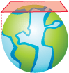
On a map, a closed shape defined by a connected sequence of x,y coordinate pairs, where the first and last coordinate pair are the same and all other pairs are unique.
See also polygon feature.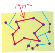
In a polygon coverage, the list of topologically connected arcs that define the boundary of a polygon feature and the label point that links it to an attribute record in the coverage point attribute table.
A map feature that bounds an area at a given scale, such as a country on a world map or a district on a city map.
See also feature.A three-dimensional object or volume defined by a number of plane faces or polygons.

In ArcGIS software, a shape defined by one or more paths, in which a path is a series of connected segments. If a polyline has more than one path (a multipart polyline), the paths may either branch or be discontinuous.
See also polyline feature, path.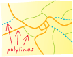
In ArcGIS software, a digital map feature that represents a place or thing that has length but not area at a given scale. A polyline feature may have one or more parts. For example, a stream is typically a polyline feature with one part. If the stream goes underground and later reemerges, it might be represented as a multipart polyline feature with discontinuous parts. If the stream diverges around an island and then rejoins itself, it might be represented as a multipart polyline feature with branching parts. A multipart polyline feature is associated with a single record in an attribute table.
See also feature.During versioned geodatabase editing, the process of applying the current edit session to the reconciled target version.
The number of times a value is to be multiplied by itself, indicated by an exponent. For example, 2 3=2*2*2.
See also exponent.The closeness of a repeated set of observations of the same quantity to one another. Precision is a measure of the control over random error. For example, assessment of the quality of a surveyor's work is based in part on the precision of their measured values.
The number of significant digits used to store numbers, particularly coordinate values. Precision is important for accurate feature representation, analysis, and mapping.
A statistical measure of repeatability, usually expressed as the variance of repeated measures about the mean.
In spatial modeling, the process of forming a statistic from observed data to assign values to random variables at locations where data has not been collected.
See also estimation.A value quantifying the uncertainty of a prediction; mathematically, the square-root of the prediction variance. (The prediction variance is the variation associated with the difference between the true and predicted value.) As a rule, 95 percent of the time the true value will lie within the predicted value plus or minus two times the prediction standard error if data is normally distributed.
See also kriging.
Used within the Survey Analyst Survey Explorer's Point Identifier field to separate the prefix and point name strings.
In coverages, refers to incomplete region topology. Region topology defines region-arc and region-polygon relationships. A topological region has both the region-arc relationship and the region-polygon relationship. A preliminary region has the region-arc relationship but not the region-polygon relationship. In other words, preliminary regions have no polygon topology. Coverages with preliminary topology have red in their icons in ArcCatalog.
A live view of GIS data in ArcCatalog. Users can pan and zoom the preview, query features, and create thumbnail images to store in metadata.
An attribute or set of attributes in a database that uniquely identifies each record. A primary key allows no duplicate values and cannot be null.
In geocoding, the most basic reference material used in an address locator, usually consisting of the geometry of features in a region and an associated address attribute table.
In geocoding, the attribute table associated with the primary reference data. Based on the address locator style selected, certain address elements must be present in the primary table.
Usually a text file named prj.adf that is associated with a coverage, GRID, or TIN. The PRJ file contains the coordinate system information for the data. In a more general sense, PRJ can refer to the coordinate system of data even if the information is not stored in a prj.adf file. For example, "The PRJ of the shapefile is WGS 1984 UTM zone 15 north."
Acronym for pseudo-random noise. A signal carrying a code that can be reproduced exactly, but appears to be randomly distributed like noise. Each NAVSTAR satellite has a unique PRN code.
Acronym for pseudo-random number. A number representing a unique GPS satellite ID or code.
Acronym for pseudo-random noise code. A repeating radio signal broadcast by each GPS satellite and generated by each GPS receiver. In a given cycle, the satellite and the receiver start generating their codes at the same moment, and the receiver measures how much later the satellite's broadcast reaches it. By multiplying that time by the speed of radio waves, the receiver can compute the distance between the satellite's antenna and its own.
A measure of the likelihood that a particular outcome, such as a spatial pattern or event, will occur given a set of possible outcomes. Probability values range from 0 for impossible outcomes to 1 for completely certain outcomes. The probability that a tossed coin will land heads-up, for example, is 0.5, since landing heads-up is one of two possible outcomes.
A surface that gives the probability that the variable of interest is above or below a specified threshold value.
See also probability.In geoprocessing in ArcGIS, a tool and its parameter values. One process, or multiple processes connected together, creates a model.
An ArcGIS Image Server operation applied to a specific raster dataset or the data in an image service. A process can modify the radiometry, geometry, or appearance of an image. Examples of ArcGIS Image Server processes include Blend Pixels, NDVI, and Stretching.
In ArcGIS Image Server, a list of raster processes that are performed on the fly by the server on raster data. The full process chain contains the raster dataset process applied to the raster data before mosaicking, and the service process applied after mosaicking.
A graph of the elevation of a surface along a specified line.
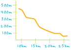
In Survey Analyst, a specific task for capturing survey data. This can include anything from a field control survey to data entry from a subdivision plan.
A specific plan, task, or scheme undertaken by a person or group of persons, usually for the purpose of problem identification and/or resolution, within a given time frame.
A geodatabase designed to manage database and map production for the Production Line Tool Set (PLTS). The PMC stores metadata and geometries of projects, products and source material.
Any data in a process that existed before the process existed.
See also input data.A measurement of locations on the earth's surface expressed in a two-dimensional system that locates features based on their distance from an origin (0,0) along two axes, a horizontal x-axis representing east–west and a vertical y-axis representing north–south. Projected coordinates are transformed from latitude and longitude to x,y coordinates using a map projection.
See also geographic coordinates.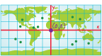
A reference system used to locate x, y, and z positions of point, line, and area features in two or three dimensions. A projected coordinate system is defined by a geographic coordinate system, a map projection, any parameters needed by the map projection, and a linear unit of measure.
A method by which the curved surface of the earth is portrayed on a flat surface. This generally requires a systematic mathematical transformation of the earth's graticule of lines of longitude and latitude onto a plane. Some projections can be visualized as a transparent globe with a light bulb at its center (though not all projections emanate from the globe's center) casting lines of latitude and longitude onto a sheet of paper. Generally, the paper is either flat and placed tangent to the globe (a planar or azimuthal projection) or formed into a cone or cylinder and placed over the globe (cylindrical and conical projections). Every map projection distorts distance, area, shape, direction, or some combination thereof.
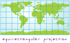
A transformation used only to transform coordinates digitized directly from high-altitude aerial photographs of relatively flat terrain, assuming there is no systematic distortion in the photographs.
See also transformation.An ellipsoid created by rotating an ellipse around its major axis.
See also oblate ellipsoid, ellipsoid, spheroid.An attribute of an object defining one of its characteristics or an aspect of its behavior.
In a geodatabase topology or ArcInfo coverage, a node connecting only two edges or arcs, or the endpoint of an edge or arc that connects to itself.
The handheld device used with a digitizer to record positions from the tablet surface.
See also digitizing.
In ArcGIS 9.1 and previous versions, a check-in operation initiated from a master geodatabase.
In ArcGIS 9.1 and previous versions, a check-in operation initiated from a checkout geodatabase.
A probability resulting from a statistical test of the coefficient associated with each independent variable in a regression model. The null hypothesis for this statistical test states that the coefficient is not significantly different from zero. Small p-values reflect small probabilities. They suggest that the coefficient is significantly different from zero, and consequently, that the associated explanatory variable is helping to model or predict the dependent variable. Variables with coefficients near zero do not help predict or model the dependent variable; they are almost always removed from the regression equation (unless there are strong theoretical reasons to keep them).
See also dependent variable, independent variable, regression coefficient.In raster datasets, a reduced resolution layer that copies the original data in decreasing levels of resolution to enhance performance. The coarsest level of resolution is used to quickly draw the entire dataset. As the display zooms in, layers with finer resolutions are drawn; drawing speed is maintained because fewer pixels are needed to represent the successively smaller areas.
A scatter chart in which the quantiles of two distributions are plotted against each other.
See also quantile.In ArcGIS Survey Analyst, when used together, the F test and W test are called the B method of testing, for which a power can be defined. This power is the Quality Beta, and can be defined as follows: the probability that the null hypothesis is accepted while, in fact, it is false, is equal to 1-b.
In a data distribution, a value representing a class break, where classes contain approximately equal numbers of observations. The p-th quantile, where p is between 0 and 1, is that value that has a proportion p of the data below the value. For theoretical distributions, the p-th quantile is the value that has p probability below the value.
A data classification method that distributes a set of values into groups that contain an equal number of values.
See also classification.A request to select features or records from a database. A query is often written as a statement or logical expression.
A type of expression that evaluates to a Boolean (true or false) value, that is typically used to select those rows in a table in which the expression evaluates to true. Query expressions are generally part of a SQL statement.
A table containing results from a query.
See also query.In ArcGIS Geostatistical Analyst, a deterministic interpolation method. The interpolated surface is forced to conform to the sample data points, and the method does not have standard errors associated with it. Spline interpolation is a special case of radial basis functions.
See also interpolation, spline interpolation.The angle subtended by an arc of a circle that is the same length as the radius of the circle, approximately 57 degrees, 17 minutes, and 44.6 seconds. There are 2π radians in one complete rotation.
Procedures that correct or calibrate aberrations in data values due to specific distortions from such things as atmosphere effects (such as haze) or instrumentation errors (such as striping) in remotely sensed data.
See also radiometric resolution.The sensitivity of a sensor to incoming reflectance. Radiometric resolution refers to the number of divisions of bit depth (for example, 255 for 8-bit, 65,536 for 16-bit, and so on) in data collected by a sensor.
The distance from the center to a point on the outer edge of a circle, circular curve, or sphere.

A parameter of a variogram or semivariogram model that represents a distance beyond which there is little or no autocorrelation among variables.
See also autocorrelation.A type of attribute domain that defines the range of permissible values for a numeric attribute. For example, the permissible range of values for a pipe diameter could be between 1 and 32 inches.
A method of assigning an accuracy value to feature classes to avoid having vertices from a feature class collected with a high level of accuracy being snapped to vertices from a less accurate feature class. Vertices from higher ranking feature classes will not be moved when snapping with vertices with lower ranked feature classes. The highest rank is one; up to 50 different ranks can be assigned.
A spatial data model that defines space as an array of equally sized cells arranged in rows and columns, and composed of single or multiple bands. Each cell contains an attribute value and location coordinates. Unlike a vector structure, which stores coordinates explicitly, raster coordinates are contained in the ordering of the matrix. Groups of cells that share the same value represent the same type of geographic feature.
In ArcGIS, an in-memory representation of a raster dataset. A raster may exist in memory as a subset of a raster dataset; it may have a different cell size than the raster dataset; or it may exist using a different transformation than the raster dataset.
An ArcGIS Spatial Analyst tool for performing mathematical calculations with operators and functions, setting up selection queries, or typing Map Algebra syntax. Inputs to the Raster Calculator can be raster datasets, raster layers, coverages, shapefiles, tables, constants and numbers.
A collection of raster datasets defined in a table of any format, in which the records define the individual raster datasets that are included in the catalog. Raster catalogs can be used to display adjacent or overlapping raster datasets without having to mosaic them together into one large file. In ArcView 3.x, raster catalogs were called image catalogs.
The process of drawing, filling, and erasing raster cells using ArcScan Raster Cleanup and Raster Painting tools.
A representation of the world as a surface divided into a regular grid of cells. Raster models are useful for storing data that varies continuously, as in an aerial photograph, a satellite image, a surface of chemical concentrations, or an elevation surface.
See also vector data model.In ArcGIS, a raster spatial data model that is stored on disk or in a geodatabase. Raster datasets can be stored in many formats, including TIFF, Imagine, ESRI Grid, and MrSid.
One layer in a raster dataset that represents data values for a specific range in the electromagnetic spectrum (such as ultraviolet, blue, green, red, and infrared), or radar, or other values derived by manipulating the original image bands. A raster dataset can contain more than one band. For example, satellite imagery commonly has multiple bands representing different wavelengths of energy from along the electromagnetic spectrum.
See also band.Three or more lines in a raster that meet at a common point.
A feature layer in ArcGlobe that exists as points, lines and polygons but is rendered as cell data. When layers are added to ArcGlobe, they may automatically be rendered in raster format to retain their cartographic symbology.
See also feature layer.In ArcGIS, a layer that references a raster as its data source and a raster renderer that defines how the raster data should be rendered and any additional display properties.
See also layer.In ArcScan, the automatic correction of vector feature results immediately after batch vectorization is completed. Postprocessing involves generalizing lines, straightening angles, and smoothing lines.
Simple raster editing that prepares images for viewing and analysis. Preprocessing includes georeferencing, clipping, positioning, resizing, enhancing, and mosaicking.
In ArcGIS Image Server, an XML file that contains properties of the raster dataset, including metadata, as well as the definition of processes to be applied to one or more individual rasters. A raster process definition file has a .RPDef extension.
Statistics that are calculated from the cell values of each band in a raster. The statistics that are calculated include the minimum, maximum, mean, and standard deviation cell values, and if the dataset is thematic, the number of classes. Statistics are required for some rendering and geoprocessing operations.
An interactive vectorization process that involves drawing along the boundary of contiguous raster cells to create vector features.
Acronym for relational database management system. A type of database in which data is organized across one or more tables. Tables are associated with each other through common fields called keys. In contrast to other database structures, an RDBMS requires few assumptions about how data is related or how it will be extracted from the database.
See also database.Data that is displayed immediately, as it is collected. Real-time data is often used for navigation or tracking.
The time mode in ArcGIS Tracking Analyst in which data is automatically displayed on the map after being added.
See also time mode.The process of taking input cell values and replacing them with new output cell values. Reclassification is often used to simplify or change the interpretation of raster data by changing a single value to a new value, or grouping ranges of values into single values—for example, assigning a value of 1 to cells that have values of 1 to 50, 2 to cells that range from 51 to 100, and so on.
In concurrency management, to merge all modified data in the current database edit session with a second version of the data.
A set of related data fields, often a row in a database, containing all the attribute values for a single feature. For example, in an address database, the fields that together provide the address for a specific individual comprise one record. In the SQL query language, a record is analogous to a tuple.
See also tuple.
The process of applying a mathematical transformation to an image so that the result is a planimetric image.
See also transformation, orthorectification, geometric correction.In Survey Analyst, occurs when the number of observed measurements is greater than the number of computed coordinates in a measurement network.
In geocoding, material containing the location and address information of specific features. Reference data consists of the spatial representation of the data and the related attribute table.
In ArcGIS, a spatial data layer that a geocoding service uses to perform address geocoding. A reference data source can be any point, line, or polygon feature class that contains the necessary address attributes. Each address component is stored as a separate attribute. The address attributes can be contained in the reference data source itself or in a table joined to it.
A map designed to show where geographic features are in relation to each other.
In Survey Analyst, a point with known coordinates, used as input to a computation.
The scale at which symbols appear on a digital page at their true size, specified in page units. As the extent is changed, text and symbols will change scale along with the display. Without a reference scale, symbols will look the same at all map scales.
A method for identifying positions on the globe. This is often constructed with a grid that either refers to the earth's latitude and longitude (graticule), or a planar equivalent that divides grid lines by a fixed length from a predefined point of origin.
In Survey Analyst, occurs when a copy of a coordinate from a different project is added to the survey point for exclusive use in your project. When this referencing happens, you must choose one of the following coordinates: the GIS coordinate or the current coordinate of the owning survey project.
A DBMS-defined restriction that ensures that foreign key values in the rows in the child table always have matching primary key values in the parent table.
See also foreign key, primary key.A mechanism for ensuring that data remains accurate and consistent as a database changes. When changes are made to a table related to another table by a common key, the changes are automatically reflected in both tables.
In geography, an area usually distinguished by common cultural or physical characteristics, such as Southern California, Western Europe, or Southeast Asia.
A set of contiguous cells with the same value.
In the coverage data structure, a polygon feature made up of multiple polygons that may be separate, overlapping, nested, or adjacent. The polygons that compose a region are stored in a polygon feature class, while the region is stored in a subclass of this feature class. A region has its own attributes but no shape geometry; its shape is defined by the shape geometry of the polygons that compose it.
A value associated with each independent variable in a regression equation, representing the strength and type of relationship the independent variable has to the dependent variable. For example, fire frequency might be modeled as a function of solar radiation, vegetation, precipitation, and aspect. A positive relationship between fire frequency and solar radiation is likely (the more sun, the more frequent the fire incidents). When the relationship is positive, the sign for the associated coefficient is also positive. A negative relationship between fire frequency and precipitation is also likely (places with more rain have fewer fires). Coefficients for negative relationships have negative signs. If the relationship is strong, the absolute value of the coefficient is large. Weak relationships are associated with coefficients near zero.
See also dependent variable, independent variable, regression equation.The mathematical formula applied to independent variables to best predict the dependent variable being modeled. The notation in regression equations is always Y for the dependent variable and X for the independent variables. Each independent variable is associated with a regression coefficient describing the strength and sign of that variable's relationship to the dependent variable. A regression equation might look like this (where b represents a regression coefficient): Y = b0 + b1X1 + b2X2 + …bnXn
See also regression coefficient, dependent variable, independent variable.Handling unmatched addresses through fine-tuning the geocoding process. After a table of addresses are matched the first time, unmatched addresses can be reviewed or edited. Reject processing attempts to find possible matches by correcting errors or adjusting search criteria for the addresses that fail the first time.
An operation that establishes a temporary connection between records in two tables using a key common to both.
See also joining, key.An ArcToolbox utility used to build, modify, save, and delete connections (relates) between tables. Saved connections can be reactivated in future ArcToolbox sessions.
A data structure in which collections of tables are logically associated with each other by shared fields.
See also RDBMS, relate, primary key, joining.In ArcGIS Spatial Analyst, an operator that evaluates specific relational conditions. If a condition is TRUE, the output is assigned a value of 1. If the condition is FALSE, the output is assigned a value of 0.
An expression used to compare values associated with data: greater than, less than, maximum, minimum, contains, and so forth.
An association or link between two objects in a database. Relationships can exist between spatial objects (features), between nonspatial objects (rows in a table), or between spatial and nonspatial objects.
An item in the geodatabase that stores information about a relationship. A relationship class is visible as an item in the ArcCatalog tree or contents view.
See also relationship.In computing, the location of a computer file given in relation to the current working directory.
See also path.In geodatabase editing, the other replica in a replica pair of parent and child. The relative replica to a child replica is the parent replica, and vice versa.
See also replica, replica pair.A map element that contains a simplified view of the sources used to compile a map.
See also map element.The process of regeocoding a feature or features in a geocoded feature class.
A mechanism that defines how data appears when displayed. For example, the hillshade renderer for raster data in ArcMap calculates and applies shading based on existing data values for slope and aspect.
The process of drawing to a display; the conversion of the geometry, coloring, texturing, lighting, and other characteristics of an object into a display image.
In 3D Analyst, a tab on the Layer Properties dialog box that allows users to control whether or not a layer is displayed during scene navigation, how it is shaded, and its drawing priority. It also allows users to adjust how the computer's memory is allocated when rendering large images.
See also rendering.The isolation level in a database management system (DBMS) that ensures that when the same rows are read multiple times during the course of a transaction, the returned values are the same between subsequent reads.
In geodatabase editing, the portion of the data in a geodatabase that is copied from a source geodatabase to a destination geodatabase during the replication process. The replica includes information needed to synchronize changes to the data. There are three types of replicas: one-way replicas, two-way replicas, and check-in/checkout replicas.
In geodatabase editing, each combination child and parent replica.
See also replica, child replica, parent replica.An XML file that describes schema differences between the data in a replica and its relative replica.
A workspace document file that describes the schema of the data in a replica.
See also replica.A means of copying and distributing data from one database to local, remote, or mobile users and then synchronizing between these databases for consistency.
In geodatabase editing, the version being replicated during the replication process. For all replica types, the replica version for a parent replica is the version the user was connected to when the replica was created. For one-way and two-way replicas, the replica version for a child replica is always the default version. Changes made to replica versions may be synchronized between the replicas.
In ArcGIS, a database that contains the schema information needed to create a geodatabase from a UML model created using a CASE tool.
In ArcGIS, extra information added to a feature or feature class that defines rules and overrides for display on a map.
In ArcGIS, a specialized geometry vertex that controls the phases of certain geometric effects in a representation rule.
In ArcGIS, the combination of symbology and any geometric effects that together define the appearance of features sharing a common representation rule ID.
See also geometric effect.The process of interpolating new cell values when transforming rasters to a new coordinate space or cell size.
See also nearest neighbor resampling, majority resampling, bilinear interpolation, cubic convolution.In a regression model, the difference between the observed Y value and the predicted Y value; the unexplained portion of the dependent variable. Predicted values rarely match observed values exactly. The residual is one measure of model fit. Large residuals indicate poor model fit.
See also regression equation, dependent variable, independent variable, trend.The detail with which a map depicts the location and shape of geographic features. The larger the map scale, the higher the possible resolution. As scale decreases, resolution diminishes and feature boundaries must be smoothed, simplified, or not shown at all; for example, small areas may have to be represented as points.
The dimensions represented by each cell or pixel in a raster.
The smallest spacing between two display elements, expressed as dots per inch, pixels per line, or lines per millimeter.
In ArcGIS, the smallest allowable separation between two coordinate values in a feature class. A spatial reference can include x, y, z, and m resolution values. The inverse of a resolution value was called a precision or scale value prior to ArcGIS 9.2.
ESRI Web site providing various online resources—such as online help, user forums, blogs, samples, user communities, developer content, and so on—to help users learn about and use a particular ESRI product. The Resource Center gateway is located at http://resources.esri.com.
A Boolean network element attribute used for limiting traversal through a network dataset. "One way street," "no trucks allowed," and "buses only" are examples of restrictions.
See also network attribute, cost, descriptor, hierarchy.A complex curve on the earth's surface that crosses every meridian at the same oblique angle. A rhumb line path follows a single compass bearing; it is a straight line on a Mercator projection, or a logarithmic spiral on a polar projection. A rhumb line is not the shortest distance between two points on a sphere.
The simplest and most widely used type of market-area analysis, in which a circle is generated around an area on a map; then the underlying demographics are extracted from the area delineated by the circle. Generally, a ring study is used to generate a rough visualization of the market area around a point.
See also market area.
In hydrology applications, another name for linear referencing. River addressing allows objects such as gauging stations to be located by their relative positions along a line feature.
See also linear referencing.Any line feature, such as a street, highway, river, or pipe, that has a unique identifier.
A path through a network.
In ArcGIS Network Analyst, a path through a network that visits a set of specified network locations. In vehicle routing problem (VRP) analysis, a route may also refer to a vehicle and its associated properties and constraints.
In ArcGIS Network Analyst, a type of network analysis that determines the best route from one network location to one or more other locations. It can also calculate the quickest or shortest route depending on the impedance chosen. The order of the stops may be determined by the user. For example, if the impedance is time, then the best route is the quickest route.
A set of tools that allows users to create and modify routes in ArcMap.
In linear referencing, linear, continuous or point features occurring along a base route system.
See also event, route event table.In linear referencing, the result of the dynamic segmentation process. A route event source serves an event table as a dynamic feature class. Every row in the table is served as a feature whose shape is calculated when needed. For example, a route event source can act as the basis of a feature layer in ArcMap.
In linear referencing, a table that stores route locations and their attributes. A route event table, at a minimum, consists of a route identifier field and a measure location field (point events) or fields (line events).
In linear referencing, a numeric or character value used to identify a route.
In linear referencing, a discrete location along a route (point) or a portion of a route (line). A point route location uses only a single measure value to describe a discrete location along a route. A line route location uses both a from- and to-measure value to describe a portion of a route.
In linear referencing, a value stored along a linear feature that represents a location relative to the beginning of the feature, or some point along it, rather than as an x,y coordinate. Measures are used to map events such as distance, time, or addresses along line features.
In linear referencing, route measure values that do not adhere to the expected behavior. Route measure anomalies can often be fixed with ArcMap route editing tools.
In linear referencing, a collection of routes with a common system of measurement stored in a single feature class (for example, a set of all highways in a county).
In ArcGIS Network Analyst, an object used in vehicle routing problem (VRP) analysis. A route renewal object specifies a depot that can be used by a particular route to load/unload the vehicle along the route as necessary so that the capacity is reset and the route can service more orders.
In ArcGIS Network Analyst, a feature used in vehicle routing problem (VRP) analysis. A route seed point can be used to cluster the orders for a specified route.
In ArcGIS Network Analyst, a feature used in vehicle routing problem (VRP) analysis. A route zone has a polygon geometry and can be used to define the area of coverage or available service for a specified route.
A record in a table.
The horizontal dimension of a table composed of a set of columns containing one data item each.
A horizontal group of cells in a raster, or pixels in an image.
A technique for adjusting the weights in a spatial weights matrix. When weights are row standardized, each weight is divided by its row sum. The row sum is the sum of weights for a feature’s neighbors.
See also spatial weights matrix, weight.Acronym for Raster Product Format. A data format composed of rectangular pixel arrays (compressed or uncompressed), produced by the National Geospatial-Intelligence Agency and U.S. allies for military applications.
A statistic computed by the regression equation to quantify model performance. The value of R-squared ranges from 0 to 100 percent. If a model fits the observed dependent variable values perfectly, the R-squared value is 1.0, although this is highly unlikely. An R-squared value like 0.49, for example, is far more likely, and means that the model explains 49% of the variation in the dependent variable.
See also dependent variable, independent variable.A procedure for adjusting the coordinates of all the data points in a dataset to allow a more accurate match between known locations and a few data points within the dataset. Rubber sheeting preserves the interconnectivity between points and objects through stretching, shrinking, or reorienting their interconnecting lines.
Error introduced by low-quality, flatbed scanners when scanning documents. For high-precision scanning, drum scanners are often used.
The ability to grow in size or complexity without showing negative effects.
In Survey Analyst, used to define measurement units based on a common standard.
The ratio or relationship between a distance or area on a map and the corresponding distance or area on the ground, commonly expressed as a fraction or ratio. A map scale of 1/100,000 or 1:100,000 means that one unit of measure on the map equals 100,000 of the same unit on the earth.
In reference to double precision, the number of digits to the right of the decimal point in a number. For example, the number 56.78 has a scale of 2.
A map element used to graphically represent the scale of a map. A scale bar is typically a line marked like a ruler in units proportional to the map's scale.
In a coordinate system, a value (usually less than one) that converts a tangent projection to a secant projection, represented by "k0" or "k." If a projected coordinate system doesn't support a scale factor, the standard lines of the projection have a scale factor of 1.0. Other points on the map have scale factors greater or less than 1.0. If a projected coordinate system supports a scale factor, the defining parameters no longer have a scale factor of 1.0.
The process of capturing data from hard-copy maps or images in digital format using a device called a scanner.
In 3D Analyst, a document containing 3D data that can be viewed in perspective.
The structure or design of a database or database object, such as a table, view, index, stored procedure, or trigger. In a relational database, the schema defines the tables, the fields in each table, the relationships between fields and tables, and the grouping of objects within the database. Schemas are generally documented in a data dictionary. A database schema provides a logical classification of database objects.
A set of rules, stored in a file, that describe the structure of an XML document. The number, type, and order of elements allowed in an XML document are described in the schema. An XML parser can compare XML documents against the schema. An XML document that uses open and close tags properly is said to be well formed; if it also follows the rules of its designated schema, it is said to be valid.
In ArcGIS 9.1 and previous versions, a type of checkout that creates the schema of the data being checked out in the checkout geodatabase but does not copy any data.
During geodatabase editing, the process of applying schema changes from a replica to the relative replica in a replica pair. Examples of schema changes include adding or dropping a field.
See also replica, relative replica, replica pair.A path to a container for file-based geographic data that can be set in the Environment Settings dialog box or at the command line, into which all automatically generated outputs will be placed.
A set of computing instructions, usually stored in a file and interpreted at run time.
A collection of Smart Data Compression (SDC) feature classes sharing attribute information with different geometries. An SDC dataset is stored in a set of related files and contains multiple feature classes. SDC is the core data structure used in ArcGIS StreetMap, ArcIMS RouteServer, RouteMAP IMS, Business Analyst, and BusinessMAP.
A highly compressed, read-only data structure that can store spatial geometry (points, lines, and polygons), and attribute data. The SDC structure supports geocoding, routing, and most spatial operations. SDC is the core data structure used in ArcGIS StreetMap, ArcIMS RouteServer, RouteMAP IMS, ArcGIS Business Analyst, and BusinessMAP.
The account used to administer ArcSDE. The SDE user requires certain advanced database privileges to configure and manage ArcSDE geodatabases and ArcSDE services.
Acronym for software development kit. A set of code libraries and related tools used to develop platform-specific applications.
Acronym for Spatial Data Transfer Standard. A data exchange format for transferring different databases between dissimilar computing systems, preserving meaning and minimizing the amount of external information needed to describe the data. All federal agencies are required to make their digital map data available in SDTS format upon request, and the standard is widely used in other sectors.
In ArcGIS Image Server, a polygon that defines the mosaic boundary of the raster dataset used in an image service. Overlapping raster datasets can be blended along the seamline by a specified width. Seamlines are created with the Seamline extension tools, and are stored as shapefiles within the image service definition.
In spatial interpolation, a polygon that forms a subset of data around the prediction location. Only data within the searching neighborhood is used for interpolation.
See also interpolation.The maximum distance in coverage units a feature can be from the current point for consideration as the closest feature. The default is the width or height of the near coverage BND (boundary) divided by 100, whichever is larger.
In network analysis, the threshold distance used to find the closest network element to a network location.
See also tolerance.A projection whose surface intersects the surface of a globe. A secant conic or cylindrical projection, for example, is recessed into a globe, intersecting it at two circles. At the lines of intersection, the projection is free from distortion.
All material used as reference data in an address locator beyond the primary reference data. Secondary reference data can consist of an Alternate Name table or a Place-Name Alias table.
In geostatistics, the assumption that a set of data comes from a random process with a constant mean, and spatial covariance that depends only on the distance and direction separating any two locations.
See also stationarity.In ArcGIS, a geometric element from which paths are constructed. A segment consists of a start point, an endpoint, and a function that describes a straight line or curve between these two points. Curves may be circular arcs, elliptical arcs, or B�zier curves.
See also path, Bezier curve.
To choose from a number or group of features or records; to create a separate set or subset.
Layers from which features can be selected in ArcMap with the interactive selection tools. Selectable layers can be chosen using the Set Selectable Layers command in the Selection menu, or on the optional Selection tab in the table of contents.
A subset of features in a layer, or records in a table, that is chosen by the software user.
A subset of the features in a layer or records in a table. ArcMap provides several ways to select features and records graphically or according to their attribute values.
In an ArcMap editing session, a small "x" located in the center of selected features. The selection anchor is used in the snapping environment, or when rotating, moving, and scaling features.
An ArcInfo Workstation file that stores the specifications of the selection criteria to be applied against specific coverages and INFO tables. It does not store the actual selected features or records, only the selection methods. Selection files are created with the WRITESELECT command in ArcPlot.
The equatorial radius of a spheroid, often referred to as "a."
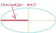
The polar radius of a spheroid, often referred to as "b."
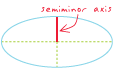
The variogram divided by two.
See also variogram.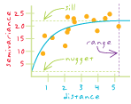
The isolation level in a database management system (DBMS) that offers the highest degree of isolation from concurrent transactions. All reads in the transaction only see data committed before the transaction began, and never see concurrent transaction changes committed during transaction execution.
See also committed read, uncommitted read, isolation level.A computer that manages shared resources, such as disks, printers, and databases, on a network.
Software that provides services or functionality to client software. For example, a Web server is software that sends Web pages to browsers.
An address locator in which processing is done on one computer with the results accessible to other computers. Server-side address locators consist of services available over the Internet, via local area networks, or via an ArcSDE server.
See also client-side address locator.A persistent software process that provides data or computing resources for client applications.
In ArcGIS Network Analyst, a type of network analysis for determining the region that encompasses all accessible streets (streets that lie within a specified impedance). For example, the 20-minute service area for a network location (such as a fire station) includes all the streets that can be reached within 20 minutes from that location.
A software program that receives service requests from clients, processes data, and serves it back to the client.
See also service.In ArcGIS Image Server, a table defining links to multiple raster datasets and some service-specific attributes, including display range. A service table is stored as part of the footprint shapefile within an image service definition.
The characteristic appearance or visible form of a geographic object as represented on a map. A GIS uses points, lines, and polygons to represent the shapes of geographic objects.
A vector data storage format for storing the location, shape, and attributes of geographic features. A shapefile is stored in a set of related files and contains one feature class.
A boundary common to two features. For example, in a parcel database, adjacent parcels share a boundary. Another example is a parcel that shares a boundary on one side with a river. The segment of the river that coincides with the parcel boundary shares the same coordinates as the parcel boundary.
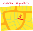
A vertex common to multiple features. For example, in a parcel database, adjacent parcels share a vertex at the common corner.
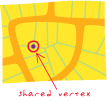
A list menu that pops up when the right mouse button is clicked in Windows applications. Some keyboards also have an application key that opens shortcut menus.
The best route or the route of least impedance between two or more points, taking into account connectivity and travel restrictions such as one-way streets and rush-hour traffic.
In ArcGIS Spatial Analyst, the least-cost path from a destination point to the nearest least-cost source.
In a spatial model, fine-scale variation that is usually modeled as spatially-dependent random variation.
An adjustable value that dictates how far away from either the left or right side of a line feature an address location should be placed. A side offset prevents a point feature from being placed directly over a line feature.
See also end offset.In Survey Analyst, used to compute a coordinate that is not a part of the main traverse course sequence.
The ratio of the information content of a signal to its noninformation content (noise).
In statistical testing, the probability of an incorrect rejection of the null hypotheses.
See also critical value, confidence level.A parameter of a variogram or semivariogram model that represents a value that the variogram tends toward when distances become large. Under second-order stationarity, variables become uncorrelated at large distances, so the sill of the semivariogram is equal to the variance of the random variable.
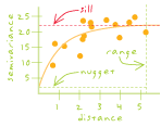
In a geodatabase, a line feature that corresponds to a single network element in the logical network.
A point, line, or polygon that is not part of a geometric network and is not an annotation feature, dimension feature, or custom object.
In a geodatabase, a junction feature that corresponds to a single network element in the logical network.
An area defined by a generalized boundary drawn around the most distant set of customer points (a convex hull) that total to some value. The calculation may be unweighted (in which case every point has the same value) or weighted by a value in the underlying database, such as sales.
See also complex market area.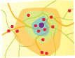
The simplest form in which measurements from COGO sources or TPS (Total Positioning System) sources can be stored.
A link or association between data sources that exist independently of each other.
In ArcGIS Tracking Analyst, an event that contains all necessary information in one temporal data message (for real-time data) or record (for fixed-time data).
A means of defining multiple units of land in a single survey document in such a way that all their boundaries have equal legal status. A common example of simultaneous conveyance is the modern subdivision.
A level of coordinate exactness based on the number of significant digits that can be stored for each coordinate. Single precision numbers store up to seven significant digits for each coordinate, retaining a precision of plus or minus 5 meters in an extent of 1,000,000 meters. Datasets can be stored in either single or double precision coordinates.
One of two types of setup pages in the Survey Analyst Survey Explorer. The single setup page is used for computations that process single instrument setups.
A geodatabase that can handle a single editor and multiple readers.
The location or group of locations used as the endpoint for distance analysis.
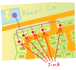
A junction feature that pulls flow toward itself through the edges of a geometric network. For example, in a river network, the mouth of a river can be modeled as a sink, since gravity pulls all water toward it.
The process of evaluating demographic data surrounding potential locations for a business, based on a user-defined trade area or areas.
In ArcMap, a shape that represents a feature's geometry. Every existing feature on a map has this alternate form, a sketch, that allows visualization of that feature's composition, with all vertices and segments of the feature visible. When features are edited in ArcMap, the sketch is modified, not the original feature. A sketch must be created in order to create a feature. Only line and polygon sketches can be created, since points have neither vertices nor segments.
In ArcMap editing, an angle or length limitation that can be placed on segments created using the Sketch tool.
In ArcMap, an editing operation that is performed on an existing sketch. Examples are Insert Vertex, Delete Vertex, Flip, Trim, Delete Sketch, Finish Sketch, and Finish Part. All of these operations are available from the Sketch shortcut menu.
In ArcMap, a tool that adds points, vertices, or segments to create an edit sketch. Sketch points can be defined by heads-up digitizing, snapping, or manually entering coordinates.
A small, narrow, polygon feature that appears along the borders of polygons following the overlay of two or more geographic datasets. Sliver polygons may indicate topology problems with the source polygon features, or they may be a legitimate result of the overlay.
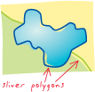
The incline, or steepness, of a surface. Slope can be measured in degrees from horizontal (0–90), or percent slope (which is the rise divided by the run, multiplied by 100). A slope of 45 degrees equals 100 percent slope. As slope angle approaches vertical (90 degrees), the percent slope approaches infinity. The slope of a TIN face is the steepest downhill slope of a plane defined by the face. The slope for a cell in a raster is the steepest slope of a plane defined by the cell and its eight surrounding neighbors.
See also aspect.
An ArcGIS geoprocessing option that snaps, or aligns, all layers to the cell registration of a specified raster. All layers will share the lower left corner and cell size of the specified raster. Snap extent is used to resample layers to the same registration and cell size in order to perform analysis.
An automatic editing operation in which points or features within a specified distance (tolerance) of other points or features are moved to match or coincide exactly with each others' coordinates.
Settings in the ArcMap Snapping Environment window and Editing Options dialog box that define the conditions in which snapping will occur. These settings include snapping tolerance, snapping properties, and snapping priority.
The order in which snapping will occur by layer during an ArcMap editing session, set from the Snapping Environment window.
In ArcMap editing, a combination of a shape to snap to and a method for determining what part of the shape will be snapped to. Snapping properties can be set to have a feature snap to a vertex, edge, or endpoint of features in a specific layer. For example, a layer snapping property might allow snapping to the vertices of buildings. A more generic, sketch-specific snapping property might allow snapping to the vertices of a sketch being created.
In an ArcGIS editing session, the distance within which the pointer or a feature will snap to another location. If the location being snapped to (vertex, boundary, midpoint, or connection) is within that distance, the pointer will automatically snap. Snapping tolerance can be measured using either map units or pixels.
An option in the Environment Setting dialog box that ensures the cell alignment of the extent will match accurately with an existing raster. This is done by snapping the lower left corner of the specified extent to the lower left corner of the nearest cell in the snap raster, and snapping the upper right corner of the specified extent to the upper right corner of the nearest cell in the snap raster.
In ArcMap, a user-assistance component that displays an on-screen description of the layer name or target being snapped to when the mouse pointer is paused over it. SnapTips only appear during an ArcMap edit session if they are enabled.
An XML-based protocol developed by Microsoft, SAP, and IBM for exchanging information between peers in a decentralized, distributed environment. SOAP allows programs on different computers to communicate independently of an operating system or platform by using the World Wide Web's Hypertext Transfer Protocol (HTTP) and XML as the basis of information exchange. SOAP is used in Web services and is now a W3C specification. SOAP was originally an acronym for Simple Object Access Protocol, but the acronym has fallen out of use.
See also TCP/IP, XML, W3C.A function that performs network analysis based on a set of network data.
The location or group of locations used as the starting point for distance analysis.
A junction feature that pushes flow away from itself through the edges of a geometric network. For example, in a water distribution network, pump stations can be modeled as sources, since they drive the water through the pipes away from the pump stations.
Vector data composed of simple lines with no topology and usually no attributes. Spaghetti lines may cross, but no intersections are created at those crossings.
Related to or existing within space.
An ArcMap editing function that allows transformation, rubber sheeting, and edgematching of data, as well as attribute transfer.
The process of examining the locations, attributes, and relationships of features in spatial data through overlay and other analytical techniques in order to address a question or gain useful knowledge. Spatial analysis extracts or creates new information from spatial data.
See also spatial modeling.A measure of the degree to which a set of spatial features and their associated data values tend to be clustered together in space (positive spatial autocorrelation) or dispersed (negative spatial autocorrelation).
See also correlation, autocorrelation.In ArcMap, a shortcut created by the user that identifies a particular geographic location to be saved for later reference.
Information about the locations and shapes of geographic features and the relationships between them, usually stored as coordinates and topology.
Any data that can be mapped.
A structured collection of spatial data and its related attribute data, organized for efficient storage and retrieval.
For a spatial dataset in ArcGIS 9.1 and previous versions, the defined precision and allowable range for x- and y-coordinates and for m- and z-values, if present.
In ArcGIS Survey Analyst, a constraint that sets the minimum and maximum values for the geometry attributes. The extents of this domain define the precision at which geometry attributes (x, y, z, m, id) can be stored as integers. There is a finite number of integers available in the system, so the x,y spatial domain is analogous to a square grid that always contains the same number of rows and columns.
In ArcGIS Spatial Analyst, an operation that performs spatial analysis. All Spatial Analyst tools in the Spatial Analyst toolbox, and operations on the ArcGIS Spatial Analyst toolbar, are classified as spatial functions. For example, distance, slope, and density are examples of spatial functions.
A two-dimensional grid system that spans a feature class. It is used to quickly locate features in a feature class that might match the criteria of a spatial search.
In a geodatabase, a mechanism for optimizing access to data based on the spatial column of the business table. In most geodatabases, a system of grids is used for the spatial index. Exceptions to this are spatial indexes used in Oracle Spatial or Informix databases, which use R-tree indexes.
A type of table join operation in which fields from one layer's attribute table are appended to another layer's attribute table based on the relative locations of the features in the two layers.
A methodology or set of analytical procedures used to derive information about spatial relationships between geographic phenomena.
See also spatial analysis.The process of superimposing layers of geographic data that cover the same area to study the relationships between them.
See also overlay.
A statement or logical expression that selects geographic features based on location or spatial relationship. For example, a spatial query might find which points are contained within a polygon or set of polygons, find features within a specified distance of a feature, or find features that are adjacent to each other.
In ArcGIS 9.2 or later, the coordinate system, tolerance, and resolution used to store a spatial dataset.
A file that quantifies spatial relationships among a set of features. Typical examples of such relationships are inverse distance, contiguity, travel time, and fixed distance.
In ArcGIS Network Analyst, an object used in vehicle routing problem (VRP) analysis. A specialty is used to represent a specific capability that may be required by certain orders and supported by certain routes. Orders requiring a given specialty may only be assigned to routes that also support that specialty. For example, an order may require an electrician, so it can only be serviced by a route that also supports the electrician specialty.
In geocoding, the degree to which the spelling variation of a street name is allowed during a search for likely match candidates. The lower the value, the more likely it is that additional candidates will be retrieved, and vice versa. This value is adjustable on the Address Locator Properties dialog box.
See also address locator.A three-dimensional shape whose center is equidistant from every point on its surface, made by revolving a circle around its diameter.

A reference system using positions of latitude and longitude to define the locations of points on the surface of a sphere or spheroid.
See also geographic coordinate system.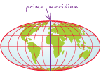
A three-dimensional shape obtained by rotating an ellipse about its minor axis, resulting in an oblate spheroid, or about its major axis, resulting in a prolate spheroid.
When used to represent the earth, a three-dimensional shape obtained by rotating an ellipse about its minor axis, with dimensions that either approximate the earth as a whole, or with a part that approximates the corresponding portion of the geoid.
In mathematics, a piecewise polynomial function used to approximate a smooth curve in a line or surface.
See also spline interpolation.
An interpolation method in which cell values are estimated using a mathematical function that minimizes overall surface curvature, resulting in a smooth surface that passes exactly through the input points.
See also spline, interpolation.A user-designated character that divides long labels into two or more lines during the labeling process. There can be more than one split character.
All attribute domains in geodatabases have a split policy associated with them. When a feature is split into two new features in ArcMap, the split policies dictate what happens to the value of the attribute with which the domain is associated. Standard split policies are duplicate, default value, and geometry ratio.
Acronym for Structured Query Language. A syntax for retrieving and manipulating data from a relational database. SQL has become an industry standard query language in most relational database management systems.
In MOLE, two or more force elements grouped together and placed one on top of another. Like leaders, stacks allow users to quickly make a map easier to read by allowing graphics to be grouped according to user-specified rules.
See also force element, tactical graphic, leader.Annotation that is stored in the geodatabase, consisting of geographically placed text strings that are not associated with features in the geodatabase.
A data classification method that finds the mean value, then places class breaks above and below the mean at intervals of either .25, .5, or 1 standard deviation until all the data values are contained within the classes. Values that are beyond three standard deviations from the mean are aggregated into two classes, greater than three standard deviations above the mean and less than three standard deviations below the mean.
See also classification.A measure of the compactness of a spatial distribution of features around its mean center. Standard distance (or standard distance deviation) is usually represented as a circle where the radius of the circle is the standard distance.
See also mean center.The federal U.S. standard for classifying establishments by their primary type of business activity. Standard Industrial Classification codes (SIC codes) are used as an identification system in business directories, publications, and statistical sources. The classification system was officially replaced by NAICS in 1997, but it is still used by some organizations outside the federal government.
A line on a sphere or spheroid that has no length compression or expansion after being projected; usually a standard parallel or central meridian.
The line of latitude in a conic or cylindrical projection in normal aspect where the projection surface touches the globe. A tangent conic or cylindrical projection has one standard parallel, while a secant conic or cylindrical projection has two. At the standard parallel, the projection shows no distortion.
See also parallel.
In programming, the current data contained by an object.
A discrete snapshot of a database whenever a change is made. Every edit operation creates a new database state, and all geodatabase versions reference one of these database states and evolve over time through a series of states.
A group of planar coordinate systems based on the division of the United States into more than 130 zones to minimize distortion caused by map projections. Each zone has its own map projection and parameters and uses either the NAD27 or NAD83 horizontal datum. The Lambert conformal conic projection is used for states that extend mostly east–west, while transverse Mercator is used for those that extend mostly north–south. The oblique Mercator projection is used for the panhandle of Alaska.
A logical organization of all the states in the geodatabase. A state tree illustrates and maintains the logical relationship between states of a versioned geodatabase.
See also state.In geostatistics, a property of a spatial process in which all statistical properties of an attribute depend only on the relative locations of attribute values.
See also second-order stationarity, intrinsic stationarity.In the pipeline industry, another name for linear referencing. Stationing allows any point along a line feature representing a pipeline to be uniquely identified by its relative position along the line feature.
A line that follows the steepest downhill direction on a surface. Paths terminate at the surface perimeter or in surface concavities or pits.
When editing in ArcMap, a setting that defines the minimum number of pixels the pointer must move on the screen before a selected feature is moved.
In Survey Analyst, a model that describes the expected error distribution of the measurements.
In ArcGIS Network Analyst, a network location used to determine a route in route analysis. Users can specify multiple stops, of which two must be used to represent an origin and a destination. Stops in between (known as intermediary stops) are visited en route from the first to the last stop.
A set of parameters that specify how data and indexes are stored in an ArcSDE database. Keywords are stored in a table in the ArcSDE database.
A type of business analysis that uses mostly data about a store or stores, rather than about customers. Examples include ring studies and analyses of equal competition areas and drive-time areas.
See also customer market analysis.A type of business analysis that assesses the potential of a site by performing simple ring or drive-time analysis.
See also site prospecting.An ArcGIS Spatial Analyst function that identifies which cells belong to which source, based on closest proximity in a straight line.
An ArcGIS Spatial Analyst function that identifies the azimuth direction from each cell to the nearest source.
An ArcGIS Spatial Analyst function that calculates the distance in a straight line from every cell to the nearest source.
A technique for transferring data, usually over the Internet, in a real-time flow as opposed to storing it in a local file first. Streaming allows large multimedia files to be viewed before the entire file has been downloaded to a client's computer. When received by the client (local computer) the data is uncompressed and displayed using software designed to interpret and display the data rapidly.
A method of digitizing in which, as the cursor is moved, points are recorded automatically at preset intervals of either distance or time.
See also point mode digitizing.During stream mode digitizing, the minimum interval between vertices. Stream tolerance is measured in map units.
A display technique applied to the histogram of raster datasets, most often used to increase the visual contrast between cells.
See also histogram.
A line feature enforced in a TIN. There are two types of structure lines: hard and soft. Hard structure lines, also known as breaklines, represent interruptions in the slope of the surface. Soft structure lines are used to add information about the surface without implying a change in the surface behavior across the line.
See also breakline.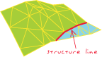
The geographic area treated in an analysis.
An organized collection of predefined colors, symbols, properties of symbols, and map elements. Styles promote standardization and consistency in mapping products.
The tool used to create new styles and edit existing ones. The Style Manager displays the contents of all the styles that are currently referenced by the map. It also contains personal and additional styles that may be used in ArcMap.
A file or form that provides style and layout information, such as margins, fonts, and alignment, for tagged content within an XML or HTML document. Style sheets are frequently used to simplify XML and HTML document design, since one style sheet may be applied to several documents. Transformational style sheets may also contain code to transform the structure of an XML document and write its content into another document.
One of several layers that are part of a group layer in a map document.
Within a geometric network, the replacement of an orphan junction by a non-orphan junction from a user-defined feature class. The original junction is deleted from the network, and the non-orphan junction assumes the connectivity of the subsumed orphan junction.
In geodatabases, a subset of features in a feature class or objects in a table that share the same attributes. For example, the streets in a streets feature class could be categorized into three subtypes: local streets, collector streets, and arterial streets. Creating subtypes can be more efficient than creating many feature classes or tables in a geodatabase. For example, a geodatabase with a dozen feature classes that have subtypes will perform better than a geodatabase with a hundred feature classes. Subtypes also make editing data faster and more accurate because default attribute values and domains can be set up. For example, a local street subtype could be created and defined so that whenever this type of street is added to the feature class, its speed limit attribute is automatically set to 35 miles per hour.
A model that weights locations relative to each other based on given criteria. Suitability models might aid in finding a favorable location for a new facility, road, or habitat for a species of bird.
A contour line placed between regularly spaced contours, used when the terrain change is not large enough to be depicted with consistent contour intervals.
See also contour line.A geographic phenomenon represented as a set of continuous data (such as elevation, geological boundaries, or air pollution); a spatial distribution which associates a single value with each position in a plane, usually associated with continuous attributes.
A representation of a geographic feature or phenomenon that can be measured continuously across some part of the earth's surface (for example, elevation). A surface model is an approximation of a surface, generalized from sample data. Surface models are stored and displayed as rasters, TINs, or terrains.
Perpendicular or normal to the slope of the surface in 3D Analyst. As changes in slope are approached across the surface, the degree of smoothness is defined by how gradual or abrupt the normals to that surface change. A smooth surface has gradual changes in the normals to the surface; a planar surface has abrupt changes.
In Survey Analyst for field measurements, the feature classes in the geodatabase that contain survey-aware features.
In Survey Analyst for field measurements, features that are associated with survey data.
In Survey Analyst for field measurements, a collection of survey objects of a particular type. A survey dataset contains a set of survey classes for each of the different types of measurements and computations. There is also a survey class for coordinates and a survey class for survey points.
In Survey Analyst for field measurements, importers that interpret operation codes and feature codes when a data collector file is imported. Users choose the converter that matches the data collector file format.
In Survey Analyst for field measurements, a dataset that stores survey objects.
In Survey Analyst for field measurements, the main interface for working with stored survey information. Data may be explored and edited directly in the Survey Explorer. Users can add lists of coordinates, measurements, and computations to the Survey Explorer so they can view and analyze numerical values of measurements and coordinates created in their survey dataset.
In Survey Analyst for field measurements, layers that are created whenever survey datasets or survey projects are added to the map. Survey layers appear in the table of contents of a map document and comprise a set of sublayers for survey points and measurements.
In Survey Analyst for field measurements, a collective term referring to measurements, computations, survey points, and coordinates in the survey dataset.
In Survey Analyst for field measurements, named locations that are observed through various surveys. Survey points can be observed multiple times and by many surveys over time. They represent multiple coordinates, but each identifies discrete physical locations on the earth's surface.
In Survey Analyst for field measurements, a subset of the survey dataset that represents a unit of work. A survey project is used as a logical structure that owns and manages a group of measurements, points, coordinates, and computations that function and belong together.
A commercial RDBMS.
A graphic used to represent a geographic feature or class of features. Symbols can look like what they represent (trees, railroads, houses), or they can be abstract shapes (points, lines, polygons) or characters. Symbols are usually explained in a map legend.
A 15-character identifier that provides the information necessary to display or transmit a tactical symbol between MIL-STD-2525B compliant systems.
In ArcGIS, a setting that determines the drawing order of features based on their symbol. When symbols have more than one layer, symbol level drawing can be used to specify the order in which each layer of the symbol is drawn.
The set of conventions, rules, or encoding systems that define how geographic features are represented with symbols on a map. A characteristic of a map feature may influence the size, color, and shape of the symbol used.
In geodatabase editing, the process of applying changes made from a replica to the relative replica in a replica pair.
The process of automatically updating certain elements of a metadata file.
In geodatabase editing, the geodatabase version that receives changes during synchronization. The synchronization version is always a child of the replica version. With one-way and two-way replication, the synchronization version is automatically reconciled and posted with the replica version. If there are conflicts between the synchronization version and the replica version, the conflicts must be resolved before more data changes can be sent.
In ArcGIS 9.1 and previous versions, a data version created in a checkout geodatabase when data is checked out to that geodatabase during disconnected editing. This version exists as a copy of the original data and represents the state of the data at the time of the checkout.
Occurring together, or at the same time.
In data transmission, precisely timed and steady transmission of information that allows for higher rates of data exchange.
The structural rules for using statements in a command or programming language.
In Survey Analyst, one type of measurement error. Systematic error follows a mathematical or physical law, and it can be corrected to comply with a known standard.
In ArcGIS, a geoprocessing tool. System tools are stored in system toolsets and can be copied to custom toolsets and/or toolboxes.
In ArcGIS, a default geoprocessing toolbox that is installed with ArcGIS. System toolboxes contain system tools, organized into toolsets for ease of access.
In ArcGIS, a subset of a geoprocessing toolbox that holds system tools.
A set of data elements arranged in rows and columns. Each row represents a single record. Each column represents a field of the record. Rows and columns intersect to form cells, which contain a specific value for one field in a record.
In ArcGIS, a tabbed list of data frames and layers (or tables) on a map that shows how the data is symbolized, the source of the data, and whether or not each layer is selectable.
A representation of tabular data for viewing and editing purposes. The table view created when a table is added to ArcMap is a copy of the actual table data stored in memory.
Descriptive information, usually alphanumeric, that is stored in rows and columns in a database and can be linked to spatial data.
See also table.In MOLE, a type of graphic that aids in regulating the movement of force units, such as lane boundaries and obstacles.
See also force element, leader, stack, war fighting symbol.In markup languages such as XML and HTML, a set of bracketed characters that define the structural purpose of a block of content.
See also label, annotation, graphic text.A pair of keywords used to set additional properties for elements that are not part of the UML specification, such as the point, line, and polygon geometry of a feature class, or the length of a field in a table.
See also UML.A projection whose surface touches the globe's without piercing it. A tangent planar projection touches the globe at one point, while tangent conic and cylindrical projections touch the globe along a line. At the point or line of tangency, the projection is free from distortion.
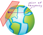
In an ArcMap editing session, the layer to which edits will be applied. The target layer must be specified when creating new features and modifying existing features.
In ArcGIS Explorer and ArcGIS Server, a user interface combined with a particular piece of GIS functionality in a format that can be easily added to applications. Tasks make it easy for the end user of an application to perform common functions, such as querying, editing, or geoprocessing. In many cases, tasks also facilitate a developer's job because they can be added to an application without requiring any code to be written.
See also tool, job.Acronym for Transmission Control Protocol/Internet Protocol. The most common protocol for Internet traffic. The Transmission Control Protocol (TCP) is a communication protocol layered above the Internet Protocol (IP), which is a suite of nonproprietary communication protocols, or sets of rules, that allow computers to send and receive data over networks.
See also SOAP.Data that specifically refers to times or dates. Temporal data may refer to discrete events, such as lightning strikes; moving objects, such as trains; or repeated observations, such as counts from traffic sensors.
See also spatial data.In ArcGIS Tracking Analyst, a type of event used to describe observations through time of particular objects or groups of objects.
All the temporal information, including the earliest and last observations, of a data layer in ArcGIS Tracking Analyst.
In ArcGIS Tracking Analyst, an object being observed through time.
The component of a complex temporal event in ArcGIS Tracking Analyst that contains feature shape and attribute information.
In ArcGIS Tracking Analyst, data gathered for a given object through time.
The component of a complex temporal event in ArcGIS Tracking Analyst that contains feature attribute information, and possibly time and date information.
See also temporal observation.A function in ArcGIS Tracking Analyst that allows users to play back the temporal display of data as if it had occurred at a user-defined date and time. The temporal offset does not change the underlying data; it simply allows the data to be displayed as if it were happening at a different time.
In ArcGIS Tracking Analyst, the time range within which data will be displayed. Temporal windows can be set at the layer level on the Symbology tab.
A dataset temporarily stored on disk or in memory.
See also permanent dataset.An area of land having a particular characteristic, such as sandy terrain or mountainous terrain.
See also surface.A multiresolution, TIN-based surface built from measurements stored as features in a geodatabase. Associated and supporting rules help organize the data and control how features are used to define the surface. Terrain datasets are typically derived from sources such as lidar, sonar, and photogrammetric data.
See also terrain, TIN.A data structure associated with a terrain dataset used to define a multi-resolution surface, which organizes data into different levels of detail, or pyramid levels, and serves to improve performance by enabling the terrain to access only the data required for a particular display or analysis function. Data that is over-sampled or redundant can be avoided.
Two pyramid types can be used to build a terrain: z-tolerance and window size. Z-tolerance pyramids filter data into different pyramid levels based on their vertical significance. Window size pyramids filter the data through localized selection biased to max, min, or mean height.
See also pyramid.In a terrain dataset, a collection of line or polygon feature classes used to represent those geographic features at different levels of detail.
An individual level of detail in a terrain dataset pyramid. Each level has a pair of properties: resolution and scale. The resolution defines the amount of detail represented by the level, and the scale is a threshold that indicates at which display scale the level becomes active.
The range of pyramid levels for which polygon or polyline features will be enforced in the surface of a terrain dataset.
See also terrain pyramid level.A spatially coherent organization of terrain data facilitating efficient retrieval and editing. Tile definition is based on the average point spacing of the source data.
See also average point spacing.An entity that displays text entered by a user or derived from another source for editing purposes.
Tags used with text in ArcGIS that allow formatting to be modified for a portion of a text string. This allows the creation of mixed-format text where, for example, one word in a sentence is underlined. Text formatting tags adhere to XML syntax rules and can be used most places where both a text string and a text symbol can be specified. The tags are most commonly used with labels, annotation, and graphic text.
Text placed next to a feature on a map to describe or identify it.
A map designed to convey information about a single topic or theme, such as population density or geology.
See also choropleth map.A surveying instrument for measuring vertical and horizontal angles, consisting of an alidade, a telescope, and graduated circles mounted vertically and horizontally.
Polygons generated from a set of sample points. Each Thiessen polygon defines an area of influence around its sample point, so that any location inside the polygon is closer to that point than any of the other sample points. Thiessen polygons are named for the American meteorologist Alfred H. Thiessen (1872-1931).
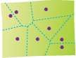
In business analysis, an operation that creates rings that contain a given population around a store or stores on a map.
A miniaturized version of a graphics file. A thumbnail can be used as a visual index for larger data or images.
In ArcGIS, a snapshot describing the geographic data contained in a data source or layer, or a map layout. A thumbnail might provide an overview of all the features in a feature class or a detailed view of the features in, and the symbology of, a layer. Thumbnails are not updated automatically; they will go out of date if features are added to a data source or if the symbology of a layer changes.
A registration or geographic control point for a coverage representing a known location on the earth's surface. Tics allow all coverage features to be recorded in a common coordinate system. Tics are used to register map sheets when they are mounted on a digitizer. They are also used to transform the coordinates of a coverage, for example, from digitizer units (inches) to the appropriate values for a particular coordinate system.
Graphics that mark divisions of measurement on a scale bar.
Short, regularly spaced lines along the edge of an image or neatline that indicate intervals of distance, such as the intersection of longitude and latitude lines to denote the graticule.
In geocoding, two or more records that yield the same score when matching an address.
A digital database of geographic features, covering the entire United States and its territories, that provides a topological description of the geographic structure of these areas. The files are a public product created from the U.S. Census Bureau Topologically Integrated Geographic Encoding and Referencing (TIGER) database. TIGER/Line files define the locations and spatial relationships of streets, rivers, railroads, and other features to each other and to the numerous geographic entities for which the Census Bureau tabulates data from its censuses and sample surveys.
One of two methods for displaying temporal data in ArcGIS Tracking Analyst: real-time mode or playback mode. Time modes are determined by the use of the Tracking Analyst Playback Manager.
In networks, the time during which a stop can be visited. For example, on a bus route, each stop may have a time window of 15 minutes. If the bus arrives before its 15-minute time slot, it will wait until the appropriate time before proceeding. If a bus arrives after its 15-minute time slot, the stop will display a symbol to denote a time violation.
See also stop, path.In ArcGIS Network Analyst, a time window violation occurs when a route arrives at a network location after its associated time window has closed.
Acronym for triangulated irregular network. A vector data structure that partitions geographic space into contiguous, nonoverlapping triangles. The vertices of each triangle are sample data points with x-, y-, and z-values. These sample points are connected by lines to form Delaunay triangles. TINs are used to store and display surface models.
See also Delaunay triangulation.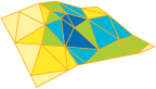
A dataset containing a triangulated irregular network (TIN). The TIN dataset includes topological relationships between points and neighboring triangles.
A layer that references a set of TIN data. TIN data contains a triangulated irregular network (TIN) and includes topological relationships between points and neighboring triangles.
See also layer.Acronym for topographic line map. A map that uses line contours to show elevations and depressions of the earth's surface. Topographic line maps may be used to portray topography, elevations, infrastructure, hydrography and vegetation.
See also topographic map.
The minimum or maximum variation allowed when processing or editing a geographic feature's coordinates. For example, during editing, if a second point is placed within the snapping tolerance distance of an existing point, the second point will be snapped to the existing point.
Of an arc's two endpoints, the last one digitized. From- and to-nodes give an arc left and right sides and, therefore, direction.
See also from-node.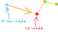
A command that requires interaction with the GUI before an action is performed. For example, a zoom tool requires a user to use the mouse to click on or draw a box over a digital map before the tool will cause the map to be redrawn at a larger scale.
A geoprocessing command in ArcGIS that performs such specific tasks as clip, split, erase, or buffer.
A graphical user interface (GUI) with buttons that allow users to execute software commands.
In ArcGIS, an object that contains toolsets and geoprocessing tools. It takes the form of a .tbx file on disk, or a table in a geodatabase.
In ArcGIS, a group of geoprocessing tools that perform similar tasks.
The description of a tool or control that is displayed on screen when the mouse is paused over it.
A map that represents the vertical and horizontal positions of features, showing relief in some measurable form, such as contour lines, hypsometric tints, and relief shading.
See also topography, TLM, planimetric map.The study and mapping of land surfaces, including relief (relative positions and elevations) and the position of natural and constructed features.
See also topographic map.The spatial relationship between features that share geometry such as boundaries and vertices. When a boundary or vertex shared by two or more features is edited using the topology tools in ArcMap, the shape of each of those features is updated.
A feature that supports network connectivity that is established and maintained based on geometric coincidence.
In geodatabases, the arrangement that constrains how point, line, and polygon features share geometry. For example, street centerlines and census blocks share geometry, and adjacent soil polygons share geometry. Topology defines and enforces data integrity rules (for example, there should be no gaps between polygons). It supports topological relationship queries and navigation (for example, navigating feature adjacency or connectivity), supports sophisticated editing tools, and allows feature construction from unstructured geometry (for example, constructing polygons from lines).
The branch of geometry that deals with the properties of a figure that remain unchanged even when the figure is bent, stretched, or otherwise distorted.
In an ArcInfo coverage, the spatial relationships between connecting or adjacent features in a geographic data layer (for example, arcs, nodes, polygons, and points). Topological relationships are used for spatial modeling operations that do not require coordinate information.
A temporary collection of edges and nodes used in ArcMap to query and edit the topological coincidence between features. The cache is built for the current display extent and is stored in the computer's memory.
In ArcMap, a predefined method for correcting topology errors. For example, predefined topology fixes for a dangling line include snapping, trimming, or extending to another line.
An instruction to the geodatabase defining the permissible relationships of features within a given feature class or between features in two different feature classes.
In ArcInfo Workstation, a network solver that determines the minimum-cost path to reach a series of stops, and also determines the order in which the stops are visited.
In Survey Analyst for field measurements, an entry in an electronic or paper field book that represents observations from a theodolite. A slope distance, vertical angle, horizontal angle, and a height of target define a single TPS measurement.
In Survey Analyst for field measurements, a group of field book entries that belong together define a single setup of the instrument. Each observation (slope distance, vertical angle, horizontal angle, and a height of target) is recorded as a TPS measurement and is added to the TPS setup. TPS is an acronym for Total Positioning System.
In ArcMap, ArcScene, and ArcGlobe, an ordered collection of similar keyframes that, when played as an animation, shows a dynamic transition between them.
In ArcGIS Tracking Analyst, a connecting line between two or more temporal events that share a common track identifier field (or ID field).
In ArcGIS Tracking Analyst, a field containing a unique identifier for a given object or objects being observed. This field is used to join the components of a complex temporal event.
A message or Internet connection whereby real-time data can stream into ArcGIS Tracking Analyst.
A group of data operations that comprise a complete operational task, such as inserting a row into a table.
A logical unit of work as defined by a user. Transactions can be data definition (create an object), data manipulation (update an object), or data read (select from an object).
An interaction with a Web service. A transaction includes a request to, and a response from, a Web service.
The process of converting the coordinates of a map or an image from one system to another, typically by shifting, rotating, scaling, skewing, or projecting them.
See also affine transformation, projective transformation, Helmert transformation, Cartesian coordinate system, rectification.
In linear referencing, an operation that produces a new table by copying and transforming events from one route reference to another. This allows the events to be used with a route reference having different route identifiers and/or measures.
A rule for adjusting the closure error in a traverse. The transit rule distributes the closure error by changing the northings and eastings of each traverse point in proportion to the northing and easting differences in each course. More specifically, a correction is computed for each northing coordinate as the difference in the course's northings divided by the sum of all the courses' northing differences. Similarly, a correction is computed for each easting coordinate using the easting coordinate differences. The corrections are applied additively to each successive coordinate pair, until the final coordinate pair is adjusted by the whole closure error amount. The transit rule assumes that course directions are measured with a higher degree of precision than the distances. Usually, observed angles are balanced for angular misclosure prior to applying a transit rule adjustment, and corrections are proportional to the x and y components of the measured line. The transit rule is used infrequently since it is only valid in cases in which the measured lines are approximately parallel to the grid of the coordinate system in which the traverse is computed.
In Survey Analyst for field measurements, one of three adjustment methods available for adjusting closure error for a traverse computation. The other two methods are the Crandall rule and the compass rule.
A method of surveying in which lengths and directions of lines between points on the earth are obtained by or from field measurements across terrain or a digital elevation model.
See also open traverse, closed loop traverse, coordinate geometry traverse.In ArcMap and Survey Analyst for field measurements, a group of observed values that define a new coordinate. A traverse course starts from a preexisting coordinate, or a coordinate computed from the previous course.
In a spatial model, nonrandom variation in the value of a variable that can be described by a mathematical function such as a polynomial.
See also short-range variation.A face on a TIN surface. Each triangle on a TIN surface is defined by three edges and three nodes and is adjacent to one to three other triangles on the surface. TIN triangles can be used to derive aspect and slope information and may be attributed with tag values.
A piece of code in a database management system (DBMS) that executes in response to data being modified with an INSERT, UPDATE, or DELETE statement.
An operator within the Raster Calculator of ArcGIS Spatial Analyst that performs various trigonometric calculations on the values in an input raster. Available trigonometric functions include Sin, Cos, Tan, Asin, Acos, and Atan.
An individual row or record in a database table. Each tuple records the values for the columns defined in the table.
In network analysis, a movement that explicitly models transitions between edge elements during navigation.
See also turn table, turn feature class, network element.
A specialized feature class that defines turn movements in an ArcGIS network dataset. Turn features explicitly model subsets of possible transitions between edge elements during navigation, and may also store the turn impedance.
See also turn, turn table.In network analysis, the cost of making a turn at a network node. The impedance for making a left turn, for example, can be different from the impedance for making a right turn or a U-turn at the same place.
In ArcInfo Workstation and ArcView GIS 3, a table that stores information about the cost of making each turn movement in a network. A turn table identifies the edge that the turn movement comes from, the junction where the turn occurs, and the edge that it turns onto.
See also turn, turn feature class.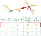
A type of geodatabase replication that allows data changes to be sent multiple times from the parent replica to the child replica or from the child replica to the parent replica. The data on both replicas must be editable, versioned and have GlobalID columns. ArcSDE geodatabases are used to create two-way replicas.
See also replica, parent replica, child replica.Acronym for United States Geological Survey. A scientific agency of the U.S. government, part of the Department of the Interior. The U.S. Geological Survey is a fact-finding research agency that monitors, analyzes, and provides scientific understanding about natural resource issues and conditions, the environment, and natural hazards. The U.S. Geological Survey is the primary civilian mapping agency in the United States. It produces digital and paper map products; aerial photography; and remotely sensed data on land cover, hydrology, geology, biology, and geography.
A custom button, tool, text box, or combo box created with VBA.
Acronym for Unified Modeling Language. A modeling language that uses a series of diagrams to model the objects in a system.
See also CASE.In Survey Analyst - Cadastral Editor, a cadastral fabric editing command that undoes the parcel generated from the build parcel command.
See also build parcel.The degree to which the measured value of some quantity is estimated to vary from the true value. Uncertainty can arise from a variety of sources, including limitations on the precision or accuracy of a measuring instrument or system; measurement error; the integration of data that uses different scales or that describe phenomena differently; conflicting representations of the same phenomena; the variable, unquantifiable, or indefinite nature of the phenomena being measured; or the limits of human knowledge. Uncertainty is often used to describe the degree of accuracy of a measurement.
See also accuracy.A parcel that is only partially defined or that is missing a sequence of one or more lines that would otherwise close the parcel back onto its point of beginning.
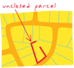
Unclosed parcels can be used to model street centerlines and other line features in the Survey Analyst - Cadastral Editor cadastral fabric.
The isolation level in an RDBMS specifying the minimum isolation from concurrent transactions. The transaction can read data that has been changed by concurrent transactions even before the changes are committed to the database.
See also committed read, serializable read, isolation level.A line that falls short of another line that it should intersect.
See also dangling arc.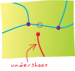
A network state in which each edge may or may not have an associated direction of flow. In an undirected network flow, the resource that traverses a network's components can decide which direction to take, such as traffic in transportation systems.
See also directed network flow.In Survey Analyst for field measurements, one of two types of lists in the List page. The uniform list has rows that represent survey objects of the same type.
A condition that occurs in a network when an edge feature is not connected through the network to sources and sinks or if the edge feature is only connected to sources and sinks through disabled features.
A topological overlay of two or more polygon spatial datasets that preserves the features that fall within the spatial extent of either input dataset; that is, all features from both datasets are retained and extracted into a new polygon dataset.
See also identity, intersect.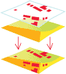
A DBMS-defined restriction specifying that each value stored in a column must be unique and that no other row can contain the same value.
A standard quantity used for measurements such as length, area, and height.
See also angular unit, linear unit, map unit, display unit, distance unit.A function for a single variable that gives the probabilities that the variable will take a given value.
In coverages, the first record in a polygon attribute table, representing the area beyond the outer boundary of the coverage.
In Survey Analyst - Cadastral Editor, a parcel that has not been connected to the cadastral fabric, and that has its own local coordinate system.
See also joined parcel, joining.In Survey Analyst for field measurements, previously uncoordinated points.
A raster catalog in which the raster datasets are not copied or altered by the geodatabase and there will only be a pointer connecting the raster catalog row to the raster datasets. Deleting a row in an unmanaged raster catalog will not delete the raster dataset from its storage location.
See also managed raster catalog.In ArcGIS, the programming object that holds updates in a delta file.
See also delta file.In network tracing, the direction along a line or edge that opposes the direction of flow.
See also downstream, directed network flow.Acronym for uniform resource locator. A standard format for the addresses of Web sites. A URL may look like this: http://www.esri.com. The first part of the address indicates what protocol to use (such as http: or ftp:), while the second part specifies the IP address or the host name (including the domain name) where the Web site is located. An optional third part may specify the path to a specific file or resource (http://www.esri.com/products.html).
The way in which statements in a command or programming language are actually used. In geoprocessing, usage for a tool or environment setting can be viewed at the command line.
See also syntax.The aspects of a computer system or program with which a software user can interact, and the commands and mechanisms used to control its operation and input data.
See also GUI.The identification used for authentication when a user logs in to a program.
Acronym for universal transverse Mercator. A projected coordinate system that divides the world into 60 north and south zones, 6 degrees wide.
Acronym for Urban Vector Map. A vector-based data product in vector product format (VPF), typically at larger scales ranging from 1:2,000 to 1:25,000. UVMap data is typically collected over densely populated urban areas.
The process of comparing the topology rules against the features in a dataset. Features that violate the rules are marked as error features. Topology validation is typically performed after the initial topology rules have been defined, after the feature classes have been modified, or if additional feature classes or rules have been added to the map topology.
A rule applied to objects in the geodatabase to ensure that their state is consistent with the system that the database is modeling. The geodatabase supports attribute, connectivity, relationship, and custom validation rules.
A component of the PLTS knowledge base that contains the valid attribute combinations and rendering information for the features in a feature class. VVTs are used to symbolize layers in batch mode, and provide a means to symbolize features based on more than three attributes.
See also knowledge base.A measurable quantity that may be passed to a function. Values are either assigned or determined by calculation.
The lightness or darkness of a color.
The brightness of a color or how much light it reflects; for instance, blue, light blue, dark blue.
A symbol or placeholder that represents a changeable value or a value that has not yet been assigned.
A symbol or quantity that can represent any value or set of values, such as a text string or number. Variables may change depending on how they are used and applied.
A drawing technique for hiding part of one layer using another set of features. Variable depth masking allows a layer to be drawn with gaps at specific locations without affecting other layers at these locations.
See also mask.A numeric description of how values in a distribution vary or deviate from the mean. The larger the variance, the greater the dispersion of values around the mean. The standard deviation for a distribution is the square root of the variance.
In surveying, the symmetric 3x3 matrix that mathematically expresses the correlation between errors in coordinates x, y, and z.
A function of the distance and direction separating two locations that is used to quantify dependence. The variogram is defined as the variance of the difference between two variables at two locations. The variogram generally increases with distance and is described by nugget, sill, and range parameters. If the data is stationary, then the variogram and the covariance are theoretically related to each other.
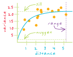
The process of examining spatial dependence using a variogram; a set of procedures (as much art as science) for interpreting variograms.
Acronym for value attribute table. A table containing attributes for a grid, including user-defined attributes, the values assigned to cells in the grid, and a count of the cells with those values.
A coordinate-based data model that represents geographic features as points, lines, and polygons. Each point feature is represented as a single coordinate pair, while line and polygon features are represented as ordered lists of vertices. Attributes are associated with each vector feature, as opposed to a raster data model, which associates attributes with grid cells.
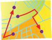
Any quantity that has both magnitude and direction.
A representation of the world using points, lines, and polygons. Vector models are useful for storing data that has discrete boundaries, such as country borders, land parcels, and streets.
The conversion of raster data (an array of cell values) to vector data (a series of points, lines, and polygons).
See also batch vectorization, centerline vectorization, interactive vectorization.GIS software settings that allow users to control the conversion of raster data to vector data. For example, vectorization settings may allow users to select which raster cells are eligible for vectorization or specify how the geometry of the output vector data will be constructed during vectorization.
An ArcScan tool that allows users to manually trace raster cells and generate features to be converted from raster to vector data.
In ArcGIS Network Analyst, a type of network analysis for routing a fleet of vehicles to service a set of orders with the goal of minimizing some objective (e.g., operating cost), while satisfying certain constraints. These constraints may include time windows, multiple route capacities, travel duration constraints, route zone and route seed point constraints, specialties constraints, and paired order constraints.
In databases, an alternative state of the database that has an owner, a description, a permission (private, protected, or public), and a parent version. Versions are not affected by changes occurring in other versions of the database.
The process of reconciling two versions of a dataset into a common version. If conflicting edits have been made in either of the merged versions, these conflicts are resolved, either automatically or by an interactive process.
The process of updating a version of a dataset with changes made in another version. Using this technique, a version can remain up to date with changes even if it is within a long transaction lasting many months.
One of a set of ordered x,y coordinate pairs that defines the shape of a line or polygon feature.
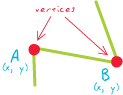
A reference system that defines the location of z-values relative to a surface. The surface may be gravity related, such as a geoid, or a more regular surface like a spheroid or sphere.
See also coordinate system.A multiplier applied uniformly to the z-values of a three-dimensional model to enhance the natural variations of its surface. Scenes may appear too flat when the range of x- and y-values is much larger than the z-values. Setting vertical exaggeration can compensate for this apparent flattening by increasing relief.
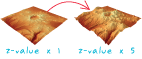
In ArcGIS, a parameter that offsets the z-origin from the surface of a vertical coordinate system. The vertical shift is similar in effect to the false easting or false northing parameters of a projected coordinate system.
In ArcGIS, a way to see the contents of a selected item in the Catalog tree in ArcCatalog.
In a database, a stored query used to display data from specified columns from one or multiple tables. Views can be used by the database administrator to restrict access to data by only displaying certain columns or to join information from two or more tables and display them in one table. In geodatabases, views can also include the spatial column of a feature class. These spatial views can be used as feature classes in ArcGIS client applications.
In ArcGlobe and 3D Analyst, an additional window that allows a user to view 3D data in a scene from another angle. Users can have multiple viewers in a scene.
The locations visible from one or more specified points or lines. Viewshed maps are useful for such applications as finding well-exposed places for communication towers, or hidden places for parking lots.
The map page as seen in layout view in ArcMap.
The current extent of a map document in ArcGIS. The virtual study area never has a boundary.
A minimum and maximum value that a map scale must fall between in order for the map layers to be displayed.
The embedded programming environment for automating, customizing, and extending ESRI applications, such as ArcMap and ArcCatalog. It offers the same tools as Visual Basic in the context of an existing application. A VBA program operates on objects that represent the application and can be used to create custom symbols, workspace extensions, commands, tools, dockable windows, and other objects that can be plugged in to the ArcGIS framework.
Acronym for Vector Map. A vector-based data product in vector product format (VPF) at several scales divided into groups, referred to as levels. For example, VMap Level 1 includes vector maps at a scale of 1:250,000, and VMap Level 2 includes vector maps at a scale of 1:50,000.
See also VPF.In a TIN, the space (measured in cubic units) between a TIN surface and a plane at a specified elevation. Volume may be calculated above or below the plane.
Acronym for Vector Product Format. A vendor-neutral data format used to structure, store, and access geographic data according to a defined standard.
A layer that references a set of VPF data. VPF data is a standard format, structure, and organization for large geographic databases that are based on a georelational data model.
See also layer.Acronym for World Wide Web Consortium. An organization that develops standards for the World Wide Web and promotes interoperability between Web technologies, such as browsers, programming languages, and devices. Members from around the world contribute to standards for XML, SOAP, HTML, and many other Web-based protocols.
Acronym for wide area network. A computer network that connects computers in a large area, such as in different cities or countries. The Internet is the most well-known example of a WAN.
In MOLE, a real-world battle element, such as a ground force unit or a lane boundary, represented by MOLE symbols on a map.
See also tactical graphic, force element, war fighting symbol.In MOLE, graphics on a map that represent battle elements such as ground troops and direction of troops. These graphics are used to plan and execute military operations in support of C4I functions. MOLE symbols fall within four main categories: force elements, tactical graphics, stacks, and leaders.
See also force element, tactical graphic.A text file that records all dialog during an ArcInfo session. Watch files can be edited and converted to macro programs.
Acronym for Web Coverage Service. A standard specification for exchanging coverages over the Internet using a server. The Web Coverage Service (WCS) is the result of a collaborative effort assembled by the Open Geospatial Consortium, Inc. (OGC).
In ArcGIS Online, a Web based, interactive map that allows you to display and query the layers on the map. A Web map contains one or more ArcGIS Server map services that are referenced to ArcGIS Online.
A set of interface specifications that provides uniform access by Web clients to maps rendered by map servers on the Internet. The Web Map Server (WMS) is the result of a collaborative effort assembled by the Open Geospatial Consortium, Inc. (OGC).
A software component accessible over the World Wide Web for use in other applications. Web services are built using industry standards such as XML and SOAP, and thus are not dependent on any particular operating system or programming language, allowing access to them through a wide range of applications.
A number that indicates the importance of a variable for a particular calculation. The larger the weight assigned to the variable, the more that variable will influence the outcome of the operation.
A property of a network element typically used to describe the element or to assign a cost for traversing the element. For example, this value may represent the phase or the length of a primary conductor in an electrical distribution system. Weights are calculated based on an attribute of each network feature.
In Survey Analyst for field measurements, one of two possibilities for performing a constrained adjustment. In the weighted constrained adjustment, the reference point coordinates are treated as observed measurements and their standard deviations are applied in the adjustment.
A technique for combining multiple rasters by applying a common measurement scale of values to each raster, weighting each according to its importance, and adding them together to create an integrated analysis.
In geometric networks, a specification for which network features can be traced based on their weight values.
Acronym for World Geodetic System 1984. The most widely used geocentric datum and geographic coordinate system today, designed by the U.S. Department of Defense to replace WGS72. GPS measurements are based on WGS84.
See also geocentric datum.An interactive user interface that helps a software user complete a task one step at a time. Wizards are often implemented as a sequence of dialog boxes that the user can move through, filling in required details. Wizards are usually used to simplify long, difficult, or complex tasks.
An organization's established processes for design, construction, and maintenance of programs, products, and business objectives.
A Microsoft SQL Server Express database that uses ArcSDE technology to store, query, and modify spatial data. Workgroup geodatabases accept up to 10 non-Web client connections and unlimited Web client connections to the SQL Server Express instance and are licensed through ArcGIS Server Workgroup edition.
A directory that indicates the appropriate location on disk to place results from analysis.
One specific task that proceeds through each stage of an organization's workflow process, including design, acceptance, and construction in the field.
A container for geographic data. A workspace can be a folder that contains shapefiles, a geodatabase, a feature dataset, or an ArcInfo workspace. Other multidimensional data formats such as netCDF or HDF can also be considered workspaces, and are often treated in this manner within GIS software packages.
In ArcObjects, a container for spatial and nonspatial datasets such as feature classes, raster datasets, and tables that provides methods to instantiate existing datasets and create new datasets. Different types of workspaces are specified by the esriWorkspaceType enumerator: esriFileSystemWorkspace (such as an ArcInfo workspace), esriLocalDatabaseWorkspace (such as a personal geodatabase), and esriRemoteDatabaseWorkspace (such as an ArcSDE geodatabase).
A type of statistical test used in surveying to detect blunders in a measurement network. The W-test is based on the assumption that the null hypothesis is rejected due to a gross error in one of the measurements and uses an alternative hypothesis to identify the erroneous measurement.
In ArcGIS desktop, this term refers to the editing tools providing visual feedback of the desired end result of an editing operation while the process is still underway. For Cartographic Representations, this is the ability to see a symbolized version of the feature being operated on instead of a wireframe version of the underlying geometry of the feature.
A pair of values that represents the distance from an origin (0,0) along two axes, a horizontal axis (x), and a vertical axis (y). On a map, x,y coordinates are used to represent features at the location they are found on the earth's spherical surface.
See also y-axis.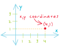
Acronym for Extensible Markup Language. Developed by the W3C, a standardized general purpose markup language for designing text formats that facilitates the interchange of data between computer applications. XML is a set of rules for creating standard information formats using customized tags and sharing both the format and the data across applications.
A language used to find specific parts of an XML document and compute values from the document's content.
See also XML, XSLT.Acronym for Extensible Style Language. A set of standards for defining XML document presentation and transformation. An XSL style sheet may contain information about how to display tagged content in an XML document, such as font size, background color, and text alignment. An XSL style sheet may also contain XSLT code that describes how to transform the tagged content in an XML document into an output document with another format. The W3C maintains the XSL standards.
See also style sheet, XML, W3C.Acronym for Extensible Style Language Transformations. A language for transforming the tagged content in an XML document into an output document with another format. An XSL style sheet contains the XSLT code that defines each transformation to be applied. Transforming a document requires the original XML document, an XSL document containing XSLT code, and an XSLT processor (parser) to execute the transformations. The W3C maintains the XSLT standard.
In a planar coordinate system, the vertical line that runs above and below (north and south of) the origin (0,0). Numbers north of the origin are positive, and numbers south of it are negative.
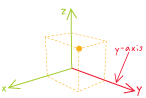
In a spherical coordinate system, a line in the equatorial plane that passes through 90 degrees east longitude.
On a chart, the vertical axis.
In Survey Analyst for field measurements, a vertical angle that is formed by the intersection of two lines in a vertical plane. Zenith angles are observed on the vertical circle of a TPS instrument.
In linear referencing, a line event whose from-measure is equal to its to-measure. A zero length line even may occur, for example, along routes, when a polygon touches a route but does not overlap it.
A conversion factor used to adjust vertical and horizontal measurements into the same unit of measure. Specifically, the number of vertical units (z-units) in each horizontal unit. For example, if a surface's horizontal units are meters and its elevation (z) is measured in feet, the z-factor is 0.3048 (the number of meters in a foot).
An enhanced ZIP Code that consists of the five-digit ZIP Code plus four additional digits that identify a specific geographic segment within the five-digit delivery area, such as a city block, office building, or other unit.
See also ZIP Code.Acronym for zone improvement plan code. A five-digit code, developed by the U.S. Postal Service, that identifies the geographic delivery area served by an individual post office or metropolitan area delivery station.
See also ZIP+4 Code.The creation of an output raster in which the desired function is computed on the cell values from the input value raster that intersect or fall within each zone of a specified input zone dataset. The input zone dataset is only used to define the size, shape, and location of each zone, while the value raster identifies the values to be used in the evaluations within the zones.
In ArcGIS Spatial Analyst, the calculation of a statistic for each zone of a zone dataset based on values from another dataset, a value raster. A single output value is computed for each cell in each zone defined by the input zone dataset.
All cells in a raster with the same value, regardless of whether or not they are contiguous.
Additional information about a location or address, used to narrow a geocoding search and increase search speed. Address elements and their related locations such as city, postal code, or country all can act as a zone.
The area in a TIN layer for which values (elevation, slope, and aspect) are calculated. When a TIN layer is clipped to a smaller size to create a more focused study area, the parts that lie outside the study area remain triangulated and are represented as outside lines, but they have no values. These parts are said to be outside the zone of interpolation.
To display a larger or smaller region of an on-screen map or image.

A statistical measure of the spread of values from their mean, expressed in standard deviation units, where the z-score of the mean value is zero and the standard deviation is one. In a normal distribution, 68 percent of the values have a z-score of plus or minus 1, meaning they lie within one standard deviation of the mean. Ninety-five percent of the values have a z-score of plus or minus 1.96, meaning they lie within two standard deviations of the mean; 99 percent of the values have a z-score of plus or minus 2.58. Z-scores are a common scale on which different distributions, with different means and standard deviations, can be compared.
In raster-to-TIN conversion, the maximum allowed difference between the z-value of the input raster cell and the z-value of the output TIN at the location corresponding to the raster cell center.
The value for a given surface location that represents an attribute other than position. In an elevation or terrain model, the z-value represents elevation; in other kinds of surface models, it represents the density or quantity of a particular attribute.