What's included with ArcGIS Server


What's included with ArcGIS Server |
|
| Release 9.3.1 |
|
ArcGIS Server 9.3 includes the following as parts of a server-based GIS:
Manager is the application you use to work with your GIS server. From Manager, you can add and remove services, tune and secure your services, and organize services in folders. Manager comes with an easy-to-use wizard for creating a Web mapping application. It also includes mechanisms for publishing ArcGIS Explorer maps and KML network links on your server. Finally, Manager allows you to configure the machines and directories in your server system and troubleshoot the server using its logs.
ArcGIS Server comes with ArcSDE, which is software that allows you to manage your GIS data in one of the following database management systems: IBM DB2, IBM Informix, Microsoft SQL Server, Oracle, or PostgreSQL. ArcSDE allows you to store your data in a central database and support the concurrent multiuser editing necessary for many data management workflows.
ArcGIS Server comes with a Web Application Developer Framework (ADF) that contains tools for building GIS Web applications. You can drag the Web ADF controls onto a Web form to quickly create an application that does mapping, editing, geocoding, geoprocessing, and more. For advanced GIS applications, you can use the Web ADF developer libraries to leverage the power of ArcObjects. The Web ADF also contains the ability to integrate multiple service types--such as ArcIMS and ArcGIS Server--into one map and provides entry points for programming with these service types using .NET or Java. When you install the Web ADF, it is automatically integrated into your development environment so that you can begin using it the next time you use Visual Studio, Eclipse, or NetBeans.
Additionally, ArcGIS Server for the Microsoft .NET Framework includes a Mobile ADF for creating applications that can run on mobile devices such as Pocket PCs and smartphones.
ArcGIS Server can be used with three JavaScript application programming interfaces (APIs) for embedding access to ArcGIS Server in your Web applications. All the code runs in the browser, and neither the client nor the Web server needs to have any GIS software installed. Three APIs are available:
Descriptions of each are available in Developing with ArcGIS Server: An overview
When developing with these APIs, you'll occasionally need to supply URLs to some of the resources on your server. The ArcGIS Services Directory is a tool that uses representational state transfer (REST) technology to help you discover information about your server and the corresponding URLs that you can use for development.
The Services Directory is also an excellent way to expose information about your server. For example, through the Services Directory, users of your server can access a geographic footprint of all available services, which they can open in Google Earth. Users can also retrieve service-level metadata about your services and preview them in a Web browser, ArcMap, ArcGIS Explorer, and Google Earth.
You can open the Services Directory through the Start menu shortcut, or by typing http://<server name>/<instance name>/rest/services in a browser.
In addition to the JavaScript APIs described above, ESRI offers the ArcGIS® API for Flex™ and the ArcGIS® API for Microsoft® Silverlight™. These APIs can help you build rich Internet mapping applications that use your ArcGIS Server. Similar to the JavaScript APIs, they work with the REST endpoints of your services to offer mapping, geocoding, queries, and geoprocessing.
The ArcGIS APIs for Flex and Silverlight are fully documented on the ArcGIS Server Resource Center. They've been designed to offer similar functionality so you can choose the platform you're most comfortable programming against.
ArcGIS Explorer is a free geospatial information viewer that you can download http://resources.esri.com/arcgisexplorer/. ArcGIS Explorer can view many types of map services--including those published with ArcGIS Server--as well as data from your local file system. Using ArcGIS Explorer, you can configure and share tasks that provide user-intuitive interfaces to geoprocessing models that run on the server.
ArcGIS Explorer is highly customizable and can be deployed as a client for ArcGIS Server projects.
The ArcGIS Server Resource Center is a central location on the Web where you can access help and information about ArcGIS Server. From the Resource Center you can get quick links to the most up-to-date help for ArcGIS Server.
Below are descriptions of some of the help systems associated with ArcGIS Server:
ArcGIS Server Help is your principal source of information for working with the GIS server. Here you'll find help for publishing services, creating and managing applications, and administering the server. ArcGIS Server Help is installed with the product and is also available online at http://webhelp.esri.com.
Developer Help contains information about the developer libraries included with the Web and Mobile ADFs. Developer Help includes conceptual information about programming with ArcGIS Server, samples that give you a chance to examine a working application, scenarios that walk you through the process of writing code to accomplish a certain objective, and object model diagrams that allow you to visualize the relationships between the programming components. In Developer Help, you'll also find all the topics from the ArcGIS Server Help. Developer Help is installed with the product and is available online at the ESRI Developer Network.
ArcGIS JavaScript API Help is available through the ArcGIS Server Resource Center. In addition to the ArcGIS JavaScript API Help, you'll also find help pages for the ArcGIS JavaScript Extensions for the Google Maps API and for Microsoft Virtual Earth (now Bing Maps). Each help site contains concepts, examples, and an API reference.
ArcGIS Explorer Help is a help system that is included with ArcGIS Explorer deployments. It explains how to navigate and configure properties within ArcGIS Explorer. It also explains how to use ArcGIS Explorer to view data and services. You can access this help from within ArcGIS Explorer or view it online at http://webhelp.esri.com.
The ArcGIS Server optional extensions allow you to add capabilities to your system and create applications leveraging advanced features. For the most recent list of extensions see http://www.esri.com/software/arcgis/arcgisserver/extensions.html The extensions include the following:
The ArcGIS Server 3D extension includes a set of 3D GIS functions to create and analyze surfaces. These functions include slope, aspect, and hillshade analysis.
The ArcGIS Server ArcPad Extension allows you to author and publish ArcPad projects to ArcGIS Server and synchronize data between ArcPad to ArcGIS Server via any internet connection. ArcGIS Server ArcPad Extension was introduced at the ArcPad 8.0 release. To learn more about this extension, see the ArcGIS ArcPad Help.
The ArcGIS Server Data Interoperability extension enables you to easily use and distribute data in many formats.
You can use the Data Interoperability extension to directly read more than 70 spatial data formats and export to more than 50 spatial data formats. ArcGIS Server complements the Data Interoperability extension by allowing you to author maps and geoprocessing tasks that support non-native data sources on your desktop and publish them to ArcGIS Server. You can publish maps that contain non-native data sources using the Data Interoperability extension's direct-read capabilities and Interoperability Connections. You can also publish geoprocessing tasks that contain conversion functions such as Quick Import, Quick Export, and the Spatial ETL tool.
Theimage extension allows you to process large volumes of raster data and serve them throughout your enterprise. Image services can include datasets with different formats, projections, and resolutions. One of the key features of the image extension is that it supports image data in its native format and does not require a special format to be created.
Clients connect to ArcGIS Server and see each image service as a single, virtual mosaic, although it could be created from large numbers of individual images. As the client pans or zooms in and out, the server extracts and processes the required data, providing a final mosaicked image to the client application. Both the data access and processing are highly optimized, making the time from request to image display nearly instantaneous.
This extension allows developers to build and deploy job tracking and workflow management systems.
The ArcGIS Server Network extension provides network-based spatial analysis capabilities including routing, travel directions, closest facility, and service area analysis. Developers can use it to build and deploy custom network applications.
The ArcGIS Server Schematics extension provides a set of functions to allow for diagram generations and updates within a web application, along with the ability to share your schematic diagrams across your enterprise and across the web within ArcGIS Server.
The ArcGIS Server Spatial extension provides a powerful set of functions that allows you to create, query, and analyze cell-based raster data.
You can use the Spatial extension to derive information about your data, identify spatial relationships, find suitable locations, calculate travel cost surfaces, and perform a wide range of additional raster geoprocessing operations.
ArcGIS Online services are a series of 2D and 3D maps that you can use to support your GIS work. These ready-to-use services can be accessed from Web Mapping Applications that you create with ArcGIS Server, as well as other ArcGIS applications.
ArcGIS Online services are always available on the Web so that users with Internet access can use these services at any time. You can use the ArcGIS Online maps as your basemap framework for deploying GIS applications to your users both inside and outside your organization.
Visit ArcGIS Online to learn more about accessing the services and what is available.
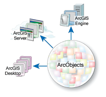
ArcGIS Server is just one of an integrated family of GIS software products for building a complete GIS. These include ArcGIS Desktop, ArcGIS Engine, ArcGIS Explorer, ArcGIS Mobile, and ArcIMS. To learn more about these products and their relationship to each other, please visit the ESRI Resource Centers.
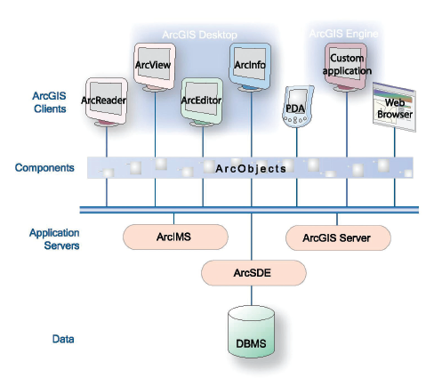
Like ArcGIS Desktop and ArcGIS Engine, ArcGIS Server is built on ArcObjects, a common library of shared GIS software components. ArcObjects components are software objects that have multiple developer APIs. These include Component Object Model (COM), .NET, Java, and C++. Developers can use these APIs to build applications that make use of ArcObjects functionality. ArcObjects is at the core of all the ArcGIS products, with ArcGIS Server providing the framework for running ArcObjects in a server environment.