Using Styled Layer Descriptors (SLDs) with WMS services


Using Styled Layer Descriptors (SLDs) with WMS services |
|
| Release 9.3.1 |
|
Styled Layer Descriptors (SLDs) allow you to publish various symbolization schemes for your WMS service using an XML specification defined by the Open Geospatial Consortium (OGC). Alternatively, clients of your service can use their own SLDs to apply the symbols they choose.
SLD styles are physically saved in the SLD file. Logically, one such SLD style defines symbolization rules for specified sets of features within a specified WMS layer. One style can have multiple rules and each rule can have one filter which describes which features should be rendered, and multiple symbolizers which describe how those features should be rendered.
Here is a sample SLD xml document:
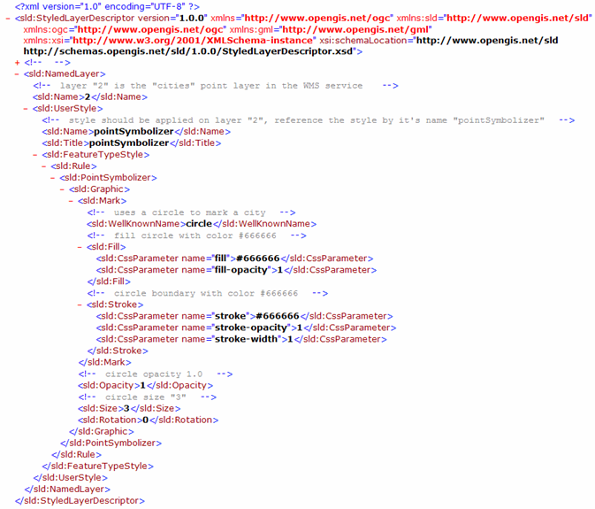
The implementation of WMS SLD in ArcGIS Server 9.3 is based on the Styled Layer Descriptor Implementation Specification. To get a general overview of SLD, see the Styled Layer Descriptor page on the OGC Web site.
You can use the following workflow to publish multiple styles for WMS layers using SLD:
To accomplish this, follow these steps in ArcCatalog or ArcGIS Server Manager:
To make sure the SLD XML is correctly bound with the WMS service, do one of the following:
Once you bind an SLD XML file to an ArcGIS Server WMS service, for each layer applicable styles will be picked up and advertised through that WMS service's capabilities information. Certain WMS client like ArcMap will then be aware of those styles and will allow you switch between those styles.
To learn how to switch to use a different style of a WMS layer, please see Properties of WMS service sublayers in the ArcGIS Desktop help.
Note: Many other WMS clients like Gaia and uDig have the feature to allow user to use different styles for a WMS layer as long as those styles are listed in WMS service's capabilities information.
With ArcGIS Server WMS services, users are not limited to the styles published on the server. Clients can reference an applicable SLD file in the WMS GetMap request so that the WMS service renders the map using their own styles.
Using an external SLD from the client side involves the following steps:
For working samples of SLDs, see the SLD samples topic.