
|
Feature classes in a geodatabase in SQL Server |
|
| Release 9.3 |    |
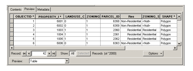 This is a polygon feature class named Parcels, which is owned by user RJP and is stored in a database named sde.
The icon to the left of the feature class name indicates the type of feature class it is. The icon above represents a polygon feature class. The icons for the other types of feature classes you can create in ArcGIS are as follows:
This is a polygon feature class named Parcels, which is owned by user RJP and is stored in a database named sde.
The icon to the left of the feature class name indicates the type of feature class it is. The icon above represents a polygon feature class. The icons for the other types of feature classes you can create in ArcGIS are as follows: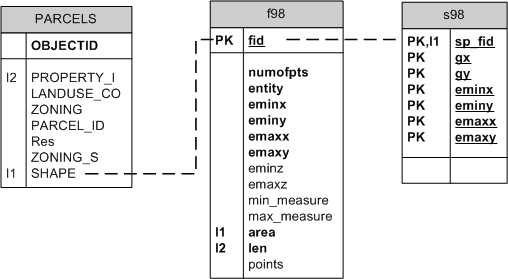
| Field name | Field type | Description |
|---|---|---|
| fid | int | Primary key The unique ID that joins the feature table to the business table |
| numofpts | int | The number of points defining the feature |
| entity | smallint | The type of geometry stored in the spatial column (for example, point, line, or string) |
| eminx | float | The minimum x-value in a feature; with eminy, emaxx, and emaxy, defines the envelope of a feature |
| eminy | float | The minimum y-value in a feature; with eminx, emaxx, and emaxy, defines the envelope of a feature |
| emaxx | float | The maximum x-value in a feature; with eminx, eminy, and emaxy, defines the envelope of a feature |
| emaxy | float | The maximum y-value in a feature; with eminx, eminy, and emaxx, defines the envelope of a feature |
| eminz | float | The minimum z-value in a three-dimensional feature, nulls allowed |
| emaxz | float | The maximum z-value in a three-dimensional feature, nulls allowed |
| min_measure | float | The minimum measure value in a feature, nulls allowed |
| max_measure | float | The maximum measure value in a feature, nulls allowed |
| area | float | The area of the geometry |
| len | float | The length or perimeter of the geometry |
| points | image | Contains the byte stream of point coordinates that define the geometry, nulls allowed |
| Field name | Field type | Description |
|---|---|---|
| sp_fid | int | Primary key; the unique ID that joins the spatial index table to the business table |
| gx | bigint | The spatial index grid x-value |
| gy | bigint | The spatial index grid y-value |
| eminx | bigint | The minimum x-value in a feature; with eminy, emaxx, and emaxy, defines the envelope of a feature |
| eminy | bigint | The minimum y-value in a feature; with eminx, emaxx, and emaxy, defines the envelope of a feature |
| emaxx | bigint | The maximum x-value in a feature; with eminx, eminy, and emaxy, defines the envelope of a feature |
| emaxy | bigint | The maximum y-value in a feature; with eminx, eminy, and emaxx, defines the envelope of a feature |
NOTE: You'll notice that once you have loaded data or run sdesetup, you will have several i tables and stored procedures in your database. These stored procedures and i tables are used for generating feature IDs for feature classes. The i tables contain a number in their name. This number corresponds to the registration_id of the feature class in the SDE_table_registry table. Editing these tables or stored procedures is not supported and highly discouraged.
All feature class business tables have a DELETE-UPDATE trigger and an INSERT trigger. The INSERT trigger ensures that the spatial column cannot have duplicate values in the business table, while the DELETE-UPDATE trigger manages activity against the spatial column in the business, feature, and spatial index tables. You can view these triggers in SQL Server Enterprise Manager or Management Studio. These triggers are automatically dropped whenever a feature class, either stand-alone or in a feature dataset, is multiversioned. They are re-created when a feature class is unregistered as versioned. If you edit one of these triggers, then register the feature class as versioned, the trigger will be dropped. Maintaining the referential integrity between the business and feature table is important. You should not edit the records of either the feature table or the spatial index table. Several indexes and constraints have been added to the business, feature, and spatial index table to ensure referential integrity is maintained. However, these indexes and constraints are removed when the feature class is converted to the load-only I/O mode, a state that allows for rapid insertion of data into the feature class. When the feature class is placed back into normal I/O mode—the state that allows users to query the feature class through a ArcGIS—the indexes are created and the constraints are enabled. The conversion to normal I/O mode will fail if the unique indexes cannot be built on the business table's spatial column or the feature table's FID column. It will also fail if a value exists in the business table's spatial column that is not in the feature table's FID column. In this case, a reference to the offending business table record is loaded into the SDE_EXCEPTIONS table.NOTE: For an explanation of the types of indexes used in SQL Server, see Indexes in geodatabases in SQL Server.
<ESRI:RecordSetData xmlns:ESRI="http://www.esri.com/schemas/ArcGIS/9.3" xmlns:xsi="http://www.w3.org/2001/XMLSchema-instance" xmlns:xs="http://www.w3.org/2001/XMLSchema">
<Data xsi:type="ESRI:RecordSet">
   <Fields xsi:type="ESRI:Fields">
     <FieldArray xsi:type="ESRI:ArrayOfField">
        <Field xsi:type="esri:Field">
              <Name>OBJECTID</Name>
              <Type>esriFieldTypeOID</Type>
              <IsNullable>false</IsNullable>
              <Length>4</Length>
              <Precision>10</Precision>
              <Scale>0</Scale>
              <Required>true</Required>
              <Editable>false</Editable>
              <DomainFixed>true</DomainFixed>
              <AliasName>OBJECTID</AliasName>
              <ModelName>OBJECTID</ModelName>
          </Field>
        <Field xsi:type="esri:Field">
              <Name>ZONING</Name>
              <Type>esriFieldTypeString</Type>
              <IsNullable>true</IsNullable>
              <Length>6</Length>
              <Precision>0</Precision>
              <Scale>0</Scale>
          </Field>
        <Field xsi:type="esri:Field">
              <Name>PARCEL_ID</Name>
              <Type>esriFieldTypeInteger</Type>
              <IsNullable>true</IsNullable>
              <Length>4</Length>
              <Precision>10</Precision>
              <Scale>0</Scale>
           </Field>
         <Field xsi:type="esri:Field">
              <Name>ZONING_S</Name>
              <Type>esriFieldTypeString</Type>
              <IsNullable>true</IsNullable>
              <Length>4</Length>
              <Precision>0</Precision>
              <Scale>0</Scale>
              <AliasName>Zoning_simple</AliasName>
              <ModelName>ZONING_S</ModelName>
            <Domain xsi:type="esri:CodedValueDomain">
                  <DomainName>ZoningCodes</DomainName>
                  <FieldType>esriFieldTypeString</FieldType>
                  <MergePolicy>esriMPTDefaultValue</MergePolicy>
                  <SplitPolicy>esriSPTDefaultValue</SplitPolicy>
                  <Description>Simplified zoning codes</Description>
                  <Owner>RJP</Owner>
                <CodedValues xsi:type="esri:ArrayOfCodedValue">
                     - <CodedValue xsi:type="esri:CodedValue">
                       <Name>Commercial</Name>
                       <Code xsi:type="xs:string">B</Code>
                  </CodedValue>
                <CodedValue xsi:type="esri:CodedValue">
                       <Name>Flood Hazard Area</Name>
                       <Code xsi:type="xs:string">FH</Code>
                  </CodedValue>
                <CodedValue xsi:type="esri:CodedValue">
                       <Name>Institutional</Name>
                       <Code xsi:type="xs:string">INST</Code>
                  </CodedValue>
                <CodedValue xsi:type="esri:CodedValue">
                       <Name>Manufacturing</Name>
                       <Code xsi:type="xs:string">M</Code>
                  </CodedValue>
                <CodedValue xsi:type="esri:CodedValue">
                       <Name>Office</Name>
                       <Code xsi:type="xs:string">O</Code>
                  </CodedValue>
                <CodedValue xsi:type="esri:CodedValue">
                       <Name>Utility</Name>
                       <Code xsi:type="xs:string">U</Code>
                  </CodedValue>
                <CodedValue xsi:type="esri:CodedValue">
                       <Name>Residential</Name>
                       <Code xsi:type="xs:string">R</Code>
                  </CodedValue>
                </CodedValues>
              </Domain>
            </Field>
          <Field xsi:type="esri:Field">
              <Name>SHAPE</Name>
              <Type>esriFieldTypeGeometry</Type>
              <IsNullable>true</IsNullable>
              <Length>4</Length>
              <Precision>0</Precision>
              <Scale>0</Scale>
              <Required>true</Required>
              <DomainFixed>true</DomainFixed>
            <GeometryDef xsi:type="esri:GeometryDef">
                  <AvgNumPoints>0</AvgNumPoints>
                  <GeometryType>esriGeometryPolygon</GeometryType>
                  <HasM>false</HasM>
                  <HasZ>false</HasZ>
            <SpatialReference xsi:type="esri:ProjectedCoordinateSystem">
  <WKT>PROJCS["NAD_1927_StatePlane_Alabama_East_FIPS_0101",GEOGCS["GCS_North_American_1927",DATUM["D_North_American_1927",SPHEROID["Clarke_1866",6378206.4,294.9786982]],PRIMEM["Greenwich",0.0],UNIT["Degree",0.0174532925199433]],PROJECTION["Transverse_Mercator"],PARAMETER["False_Easting",500000.0],PARAMETER["False_Northing",0.0],PARAMETER["Central_Meridian",-85.83333333333333],PARAMETER["Scale_Factor",0.99996],PARAMETER["Latitude_Of_Origin",30.5],UNIT["Foot_US",0.3048006096012192]]</WKT>
                   <XOrigin>489871.255812</XOrigin>
                   <YOrigin>665787.099562</YOrigin>
                   <XYScale>499999.999534338</XYScale>
                   <ZOrigin>0</ZOrigin>
                   <ZScale>1</ZScale>
                   <MOrigin>0</MOrigin>
                   <MScale>1</MScale>
                   <XYTolerance>6.56166666666667E-04</XYTolerance>
                   <ZTolerance>2</ZTolerance>
                   <MTolerance>2</MTolerance>
                   <HighPrecision>true</HighPrecision>
              </SpatialReference>
        <GridSize0>147.850872887221</GridSize0>
     </GeometryDef>
     <AliasName>SHAPE</AliasName>
     <ModelName>SHAPE</ModelName>
  </Field>
.
...all other fields...
.
<Records xsi:type="esri:ArrayOfRecord">
<Record xsi:type="esri:Record">
    <Values xsi:type="esri:ArrayOfValue">
         <Value xsi:type="xs:int">1</Value>
         <Value xsi:type="xs:double">5001</Value>
         <Value xsi:type="xs:string">0</Value>
         <Value xsi:type="xs:string">1</Value>
         <Value xsi:type="xs:int">6358</Value>
         <Value xsi:type="xs:short">0</Value>
         <Value xsi:nil="true" />
        <Value xsi:type="esri:PolygonB">
  <Bytes>BQAAAKIY/59+HR9BrcL/v636JEGMRP8feSgfQW+IAWB0ByVBAQAAAEIAAAAAAAAAjET/H3koH0Ga SQAg2/okQQCK49sGKB9BIJnG2MX6JEF10wDAiScfQa3C/7+t+iRBxksA4CsnH0G+SgAgJPskQYnQ AMDOJh9BlEwAoJn7JEFrJP2fqCYfQYzTAMDJ+yRB3kgA4HEmH0ExyP+/DvwkQWcj/Z9nJh9BnE4A oBv8JEGMSABgXSYfQZjI/38o/CRBT8H//xsmH0Hiyf//evwkQSpHAOAEJh9BjlAAIJj8JEH4pv3/ vSUfQbzL/3/x/CRBs7///7QlH0Hqy////PwkQcZFAOCrJR9BT1IAYAj9JEGmOP+ffyUfQffM/z9A /SRBkEQAYF4lH0HWUwAgav0kQTe+//9VJR9ByM3/f3T9JEHP8dfUOSUfQcfPvPCU/SRBWckAwAIl H0F/VQBg1P0kQZu7//+uJB9BJVcA4D3+JEHBTAGgTiQfQRFZAOC4/iRBJDP/Hx8kH0H6WQAg8/4k QX4y/5/1Ix9BnNT/fyn/JEEO0QEA1CMfQT7V//9R/yRBdD0AYJcjH0GnXABgnv8kQazPAYB7Ix9B /Nb/f8H/JEHltf9/QSMfQSHY/78KACVBoDsAYCIjH0H1XgDgMQAlQSfBAED2Ih9B1F8AoGkAJUGF wADAzSIfQaBgAKCcACVB1qEh4aMiH0H0v/AJyQAlQdtRAmB5Ih9BBmIAIPYAJUFOK/+fKSIfQWHd /79aASVByCn/H8ghH0FN3/+/1QElQQ4p/5+ZIR9Bb2YAYBACJUHSNADgbiEfQQ/h/z9GAiVBGa7/ f04hH0HqZwAgbwIlQSet//8RIR9BG2kAYLsCJUG3rP//9SAfQXHj/7/eAiVBdz4BILwgH0GV5P+/ JwMlQYoxAOCcIB9BMuX//04DJUFqJP+fcCAfQRHm/7+GAyVBf7YAQEwgH0HJ5v+/tAMlQf4fai4i IB9BG2B5uuQDJUHBqP9/+B8fQYRuAKAVBCVBTQj9H6EfH0EC6v//ggQlQahwAFCdHx9B+D0AzIcE JUHdpf9/Px8fQSZyACD+BCVBj7EAQBAfH0Ft4P6/OQUlQeewAEDmHh9B6HMAoG4FJUHzo///xB4f QVju/3+YBSVBPCkAYIkeH0GF7/+/4wUlQVoc/59sHh9BTnYAIAgGJUGtof9/Mx4fQW53ACBQBiVB LaH/fxMeH0EPeABgeAYlQeusAEDnHR9Bt/L/P7AGJUG2Gf+fwx0fQaJ5ACDdBiVBQ6wAQL0dH0GL 8/8/5QYlQXOOjgyeHR9Bh9WzdRMHJUGiGP+ffh0fQf70//9BByVB564AQGYeH0FviAFgdAclQY4G QeGNHh9BZOAZwkIHJUFBT7UiFSEfQcjAtugYBCVBro012pQjH0F8LBZ++AAlQYyEDuMmJh9BRZwe KMH9JEGMRP8feSgfQZpJACDb+iRB</Bytes>
          </Value>
        <Value xsi:type="xs:double">112367.21137978</Value>
      <Value xsi:type="xs:double">3597.78157570024</Value>
    </Values>
   </Record>
.
...all other records...
.
 </Data>
</esri:RecordSetData>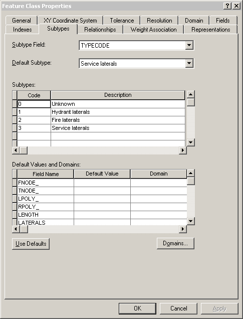 This example shows subtypes applied to the TYPECODE field for a feature class called Laterals. You see the codes used for the subtypes, the descriptions (names) of the subtypes, and the default subtype for the TYPECODE field in the Laterals feature class.
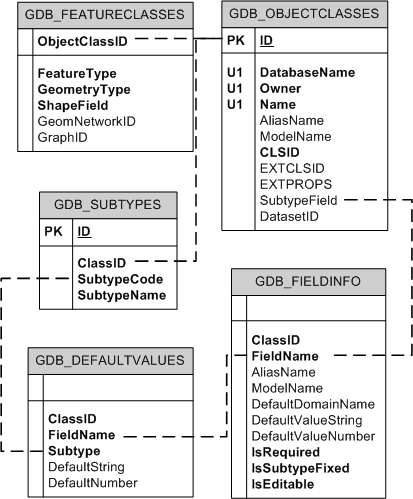 The subtypes for feature classes are tracked in the GDB_SUBTYPE system table, the default values for the subtypes are tracked in the GDB_DEFAULTVALUES system table, and the fields to which these apply are tracked in the GDB_FIELDINFO system table. The subtypes are associated to the feature class by way of the GDB_OBJECTCLASSES table. The GDB_DEFAULTVALUES table is associated with the GDB_SUBTYPES table by the subtype code, which is stored in the SubtypeCode field in the GDB_SUBTYPES table and the Subtype field in the GDB_DEFAULTVALUES table.
The name of the field to which the subtype applies is stored in the SubtypeField column of the GDB_OBJECTCLASSES table. This field is linked to the FieldName column in the GDB_FIELDINFO table, which in turn is associated to the FieldName column in the GDB_DEFAULTVALUES table.
The subtypes for feature classes are tracked in the GDB_SUBTYPE system table, the default values for the subtypes are tracked in the GDB_DEFAULTVALUES system table, and the fields to which these apply are tracked in the GDB_FIELDINFO system table. The subtypes are associated to the feature class by way of the GDB_OBJECTCLASSES table. The GDB_DEFAULTVALUES table is associated with the GDB_SUBTYPES table by the subtype code, which is stored in the SubtypeCode field in the GDB_SUBTYPES table and the Subtype field in the GDB_DEFAULTVALUES table.
The name of the field to which the subtype applies is stored in the SubtypeField column of the GDB_OBJECTCLASSES table. This field is linked to the FieldName column in the GDB_FIELDINFO table, which in turn is associated to the FieldName column in the GDB_DEFAULTVALUES table.
- <Subtypes xsi:type="esri:ArrayOfSubtype">
  <Subtype xsi:type="esri:Subtype">
      <SubtypeName>Unknown</SubtypeName>
      <SubtypeCode>0</SubtypeCode>
    <FieldInfos xsi:type="esri:ArrayOfSubtypeFieldInfo">
      <SubtypeFieldInfo xsi:type="esri:SubtypeFieldInfo">
          <FieldName>H_CONFID</FieldName>
          <DefaultValue xsi:type="xs:int">0</DefaultValue>
        </SubtypeFieldInfo>
      <SubtypeFieldInfo xsi:type="esri:SubtypeFieldInfo">
          <FieldName>DIAMETER</FieldName>
          <DomainName>LatDiameter</DomainName>
          <DefaultValue xsi:type="xs:double">8</DefaultValue>
        </SubtypeFieldInfo>
      <SubtypeFieldInfo xsi:type="esri:SubtypeFieldInfo">
          <FieldName>DEPTH_BURI</FieldName>
          <DefaultValue xsi:type="xs:double">0</DefaultValue>
        </SubtypeFieldInfo>
      <SubtypeFieldInfo xsi:type="esri:SubtypeFieldInfo">
          <FieldName>RECORDED_L</FieldName>
          <DefaultValue xsi:type="xs:double">0</DefaultValue>
        </SubtypeFieldInfo>
      <SubtypeFieldInfo xsi:type="esri:SubtypeFieldInfo">
          <FieldName>WNM_TYPE</FieldName>
          <DefaultValue xsi:type="xs:string">WUNKNOWN</DefaultValue>
        </SubtypeFieldInfo>
      <SubtypeFieldInfo xsi:type="esri:SubtypeFieldInfo">
          <FieldName>PWTYPE</FieldName>
          <DefaultValue xsi:type="xs:string">WUNKNOWN</DefaultValue>
        </SubtypeFieldInfo>
      <SubtypeFieldInfo xsi:type="esri:SubtypeFieldInfo">
          <FieldName>MATERIAL</FieldName>
          <DomainName>Material</DomainName>
          <DefaultValue xsi:type="xs:string">DI</DefaultValue>
        </SubtypeFieldInfo>
      <SubtypeFieldInfo xsi:type="esri:SubtypeFieldInfo">
          <FieldName>TYPECODE</FieldName>
          <DefaultValue xsi:type="xs:int">3</DefaultValue>
        </SubtypeFieldInfo>
      <SubtypeFieldInfo xsi:type="esri:SubtypeFieldInfo">
          <FieldName>ENABLED</FieldName>
          <DomainName>EnabledDomain</DomainName>
          <DefaultValue xsi:type="xs:short">1</DefaultValue>
        </SubtypeFieldInfo>
     </FieldInfos>
  </Subtype>
<Subtype xsi:type="esri:Subtype">
    <SubtypeName>Hydrant laterals</SubtypeName>
    <SubtypeCode>1</SubtypeCode>
  <FieldInfos xsi:type="esri:ArrayOfSubtypeFieldInfo">
      <SubtypeFieldInfo xsi:type="esri:SubtypeFieldInfo">
          <FieldName>H_CONFID</FieldName>
          <DefaultValue xsi:type="xs:int">0</DefaultValue>
        </SubtypeFieldInfo>
      <SubtypeFieldInfo xsi:type="esri:SubtypeFieldInfo">
          <FieldName>DIAMETER</FieldName>
          <DomainName>LatDiameter</DomainName>
          <DefaultValue xsi:type="xs:double">8</DefaultValue>
        </SubtypeFieldInfo>
      <SubtypeFieldInfo xsi:type="esri:SubtypeFieldInfo">
          <FieldName>DEPTH_BURI</FieldName>
          <DefaultValue xsi:type="xs:double">0</DefaultValue>
        </SubtypeFieldInfo>
      <SubtypeFieldInfo xsi:type="esri:SubtypeFieldInfo">
          <FieldName>RECORDED_L</FieldName>
          <DefaultValue xsi:type="xs:double">0</DefaultValue>
        </SubtypeFieldInfo>
      <SubtypeFieldInfo xsi:type="esri:SubtypeFieldInfo">
          <FieldName>WNM_TYPE</FieldName>
          <DefaultValue xsi:type="xs:string">WHYDLIN</DefaultValue>
        </SubtypeFieldInfo>
      <SubtypeFieldInfo xsi:type="esri:SubtypeFieldInfo">
          <FieldName>PWTYPE</FieldName>
          <DefaultValue xsi:type="xs:string">WHYDLIN</DefaultValue>
        </SubtypeFieldInfo>
      <SubtypeFieldInfo xsi:type="esri:SubtypeFieldInfo">
          <FieldName>MATERIAL</FieldName>
          <DomainName>Material</DomainName>
          <DefaultValue xsi:type="xs:string">DI</DefaultValue>
        </SubtypeFieldInfo>
      <SubtypeFieldInfo xsi:type="esri:SubtypeFieldInfo">
          <FieldName>ENABLED</FieldName>
          <DomainName>EnabledDomain</DomainName>
          <DefaultValue xsi:type="xs:short">1</DefaultValue>
        </SubtypeFieldInfo>
     </FieldInfos>
  </Subtype>
<Subtype xsi:type="esri:Subtype">
    <SubtypeName>Fire laterals</SubtypeName>
    <SubtypeCode>2</SubtypeCode>
  <FieldInfos xsi:type="esri:ArrayOfSubtypeFieldInfo">
      <SubtypeFieldInfo xsi:type="esri:SubtypeFieldInfo">
          <FieldName>H_CONFID</FieldName>
          <DefaultValue xsi:type="xs:int">0</DefaultValue>
        </SubtypeFieldInfo>
      <SubtypeFieldInfo xsi:type="esri:SubtypeFieldInfo">
          <FieldName>DIAMETER</FieldName>
          <DomainName>LatDiameter</DomainName>
          <DefaultValue xsi:type="xs:double">8</DefaultValue>
        </SubtypeFieldInfo>
      <SubtypeFieldInfo xsi:type="esri:SubtypeFieldInfo">
          <FieldName>DEPTH_BURI</FieldName>
          <DefaultValue xsi:type="xs:double">0</DefaultValue>
        </SubtypeFieldInfo>
      <SubtypeFieldInfo xsi:type="esri:SubtypeFieldInfo">
          <FieldName>RECORDED_L</FieldName>
          <DefaultValue xsi:type="xs:double">0</DefaultValue>
        </SubtypeFieldInfo>
      <SubtypeFieldInfo xsi:type="esri:SubtypeFieldInfo">
          <FieldName>WNM_TYPE</FieldName>
          <DefaultValue xsi:type="xs:string">WFIRELIN</DefaultValue>
        </SubtypeFieldInfo>
      <SubtypeFieldInfo xsi:type="esri:SubtypeFieldInfo">
          <FieldName>PWTYPE</FieldName>
          <DefaultValue xsi:type="xs:string">WFIRELIN</DefaultValue>
        </SubtypeFieldInfo>
      <SubtypeFieldInfo xsi:type="esri:SubtypeFieldInfo">
          <FieldName>MATERIAL</FieldName>
          <DomainName>Material</DomainName>
         <DefaultValue xsi:type="xs:string">DI</DefaultValue>
        </SubtypeFieldInfo>
      <SubtypeFieldInfo xsi:type="esri:SubtypeFieldInfo">
          <FieldName>ENABLED</FieldName>
          <DomainName>EnabledDomain</DomainName>
          <DefaultValue xsi:type="xs:short">1</DefaultValue>
        </SubtypeFieldInfo>
     </FieldInfos>
  </Subtype>
<Subtype xsi:type="esri:Subtype">
    <SubtypeName>Service laterals</SubtypeName>
    <SubtypeCode>3</SubtypeCode>
  <FieldInfos xsi:type="esri:ArrayOfSubtypeFieldInfo">
      <SubtypeFieldInfo xsi:type="esri:SubtypeFieldInfo">
          <FieldName>H_CONFID</FieldName>
          <DefaultValue xsi:type="xs:int">0</DefaultValue>
        </SubtypeFieldInfo>
      <SubtypeFieldInfo xsi:type="esri:SubtypeFieldInfo">
          <FieldName>DIAMETER</FieldName>
          <DomainName>LatDiameter</DomainName>
          <DefaultValue xsi:type="xs:double">8</DefaultValue>
        </SubtypeFieldInfo>
      <SubtypeFieldInfo xsi:type="esri:SubtypeFieldInfo">
          <FieldName>DEPTH_BURI</FieldName>
          <DefaultValue xsi:type="xs:double">0</DefaultValue>
        </SubtypeFieldInfo>
      <SubtypeFieldInfo xsi:type="esri:SubtypeFieldInfo">
          <FieldName>RECORDED_L</FieldName>
          <DefaultValue xsi:type="xs:double">0</DefaultValue>
        </SubtypeFieldInfo>
      <SubtypeFieldInfo xsi:type="esri:SubtypeFieldInfo">
          <FieldName>WNM_TYPE</FieldName>
          <DefaultValue xsi:type="xs:string">WSERVICE</DefaultValue>
        </SubtypeFieldInfo>
      <SubtypeFieldInfo xsi:type="esri:SubtypeFieldInfo">
          <FieldName>PWTYPE</FieldName>
          <DefaultValue xsi:type="xs:string">WSERVICE</DefaultValue>
       </SubtypeFieldInfo>
     <SubtypeFieldInfo xsi:type="esri:SubtypeFieldInfo">
          <FieldName>MATERIAL</FieldName>
          <DomainName>Material</DomainName>
          <DefaultValue xsi:type="xs:string">DI</DefaultValue>
        </SubtypeFieldInfo>
      <SubtypeFieldInfo xsi:type="esri:SubtypeFieldInfo">
          <FieldName>ENABLED</FieldName>
          <DomainName>EnabledDomain</DomainName>
          <DefaultValue xsi:type="xs:short">1</DefaultValue>
        </SubtypeFieldInfo>
     </FieldInfos>
   </Subtype>
 </Subtypes>