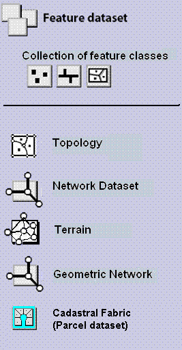
A feature dataset is a collection of related feature classes that share a common coordinate system. Feature datasets are used to spatially or thematically integrate related feature classes. Their primary purpose is for organizing related feature classes into a common dataset for building a topology, a network dataset, a terrain dataset, or a geometric network.
Using feature datasets
Use feature datasets to organize spatially related feature classes into a common dataset:
To add a Topology
To add a Network Dataset
To add a Geometric Network
To add a Terrain Dataset
To add a Cadastral Fabric Dataset
There are additional situations in which users apply feature datasets in their geodatabases:
To organize thematically related feature classes
Sometimes, users will organize a collection of feature classes for a common theme into a single feature dataset. For example, users might have a feature dataset for Water that contains Hydro Points, Hydro Lines, and Hydro Polygons.
To organize data access based on database privileges
Sometimes, users organize data access privileges using feature datasets. All feature classes contained within a feature dataset have the same access privileges. For example, users might need to use more than one feature dataset to segment a series of related feature classes to account for differing access privileges between users. Each group has editing access to one of the feature datasets and its feature classes, but no edit access for the others.
To organize feature classes for data sharing
In some data sharing situations, collaborating organizations might agree on a data sharing schema for sharing datasets with other users. In these situations, people might use feature datasets as folders to organize collections of simple feature classes for sharing with others.
Specifying the coordinate system up front
Another design factor in organizing feature classes into common feature datasets is the requirement to use a spatial reference. Thus, it's useful to define your coordinate system requirements for each feature class prior to organizing feature classes into common feature datasets.
When creating a new feature dataset, you must define its spatial reference. This includes its coordinate system—either geographic or a specific projection—as well as coordinate units and tolerances for x,y, z-, and m-values. All feature classes in the same feature dataset must share a common coordinate system, and x,y coordinates of their features should fall within a common spatial extent.
See An overview of spatial references for information on defining the coordinate system and spatial reference.