NOTE: In ArcGIS, rows are also known as records and columns as fields or attributes.
There are many mapping, analysis, and data management tasks you can perform using tabular data.
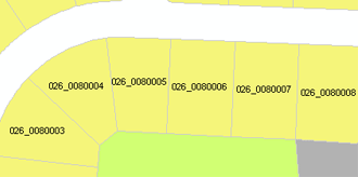
- Tables allow you to map and visualize your data. For example, you can classify or categorize attributes to symbolize a layer. You can use population values to symbolize major cities with a larger symbol than used for smaller towns and villages. You can also specify that a different color be used to represent each type of land use in a parcel layer. In addition, you can use the attribute values to generate text to label each parcel feature. In the graphic below, the parcels are symbolized by the type of land use, then labeled with their parcel ID values.
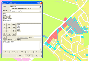
- Attribute data helps you perform spatial queries and analyses. For example, you can examine the distribution of features with certain attributes by asking ArcMap to select the features that contain the attributes you want to examine. In the graphic below, the features with a LAND_USE of UNK (unknown) are selected using an attribute query.
- When information in your geodatabase changes, you can update your attributes. For example, you'll need to update your database when land uses or property ownership changes or the unknown values are classified. If you have a feature class representing some pipes with a field for the diameter, you can easily change the attributes when the crew removes an eight-inch pipe and replaces it with a six-inch pipe. You can edit tabular values either within the table window or the Attributes dialog box, which shows attributes of only individual selected features.
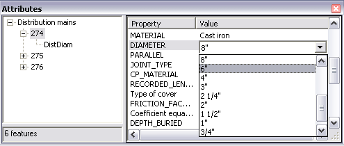
- The geodatabase includes functionality that allows you to enhance, maintain, and enforce the integrity of your tabular data. For example, by establishing attribute domains, you can set up rules that specify the valid values for the records in your table. For example, when updating pipe diameter attributes, you can use attribute domains to ensure that the diameter is appropriate for that section of pipe. ensure that the values you enter are within a valid range. The graphic below shows the use of when editing, which allows you to choose a value from a predefined list and avoid making typographic errors.
- The geodatabase also allows you to create and manage a set of attribute subclasses within a single table by using subtypes. Each subtype can have its own set of attribute domains and default values for a given field. For example, you could create subtypes for water mains such as distribution mains and transition mains, each subtype having its own set of default values and attribute domains.
- Building relationships between tables allows you to associate records in one table with records in another through a common field, known as a key. You can make these associations in several ways including by joining or relating tables temporarily in your map or by creating relationship classes in your geodatabase that maintain more permanent associations. For example, you could associate a table of parcel ownership information to the parcels layer, since they share a parcel ID field.
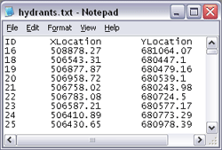
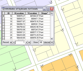
- ArcGIS also allows you to convert data in a table into spatial data. For example, one of the most common data sources is a list of coordinates obtained from using a GPS unit in the field. You can easily add such x,y data to ArcMap to display it. The graphics below show a text file containing the x,y locations of hydrants (top graphic), then the points displayed in ArcMap on the map and in a table window (bottom graphic).
 Learn more about adding x,y data as a layer.
- If you have a list of addresses, you can use geocoding to match them to known street locations to create point features. In addition, through linear referencing, you can indicate events along line features with just an identifier and a location.
Learn more about geocoding.Learn more about linear referencing.
- Tables are also at the root of data models, which are templates that you can use to set up your geodatabase to better model real-world phenomena.
Learn more about data models.
Below are some common tables-related tasks and information about where you can go in this help system to find more information. Click the links to go to more detailed help topics.
In addition, there are many geoprocessing tools available within ArcGIS that allow you to perform tasks such as data conversion and management on tables and attribute data. Many tools are available with any ArcGIS license, although some may require an ArcEditor or ArcInfo license. See the documentation for the particular tool for details on usage, parameters, and licenses.
| Common task or workflow |
Where to go for more information |
Available geoprocessing tools |
|---|
| Creating a new table
|
Creating tables
To learn about other types of data sources you can use in tables, see Creating new tables and About tabular data sources.
|
Create Table
|
| Importing, copying, and converting tabular data sources |
Importing tables
An overview of adding datasets to the geodatabase
To learn about the importing process and the geodatabase, see How data converts when importing.
|
Table To Geodatabase
Table To Table
Table To dBASE
Copy Rows
|
| Adding fields |
Adding and deleting fields
To learn about fields and their data types, see Geodatabase field data types.
|
Add FieldDelete Field
|
| Displaying tables |
Adding and viewing tables in ArcMap
Previewing a table in ArcCatalog
Setting field properties, aliases, and table display options
|
Make Table View
|
| Creating associations among tables such as joining, relating, and using relationship classes |
About joining and relating tables
Joining tables
Relating tables
Relationships and ArcGIS
Deciding between relationship classes, joins, and relates
|
Add JoinRemove Join
Create Relationship Class
|
| Editing attribute values |
Editing values in a table
Editing attributes
|
|
| Calculating the values in fields |
Making field calculations
Working with date fields
|
Calculate Field |
| Printing tables
|
Printing a table |
|
| Creating a layer from a table with x,y coordinate data
|
Adding x,y coordinate data as a layer
|
Make XY Event Layer |
| Using |
An overview of linear referencing |
An overview of the Linear Referencing toolbox
|
| a table of addresses
|
An overview of geocoding |
An overview of the Geocoding toolbox |


