 |
DBTUNE configuration parameter name-configuration string pairs |
|
| Release 9.3 |    |
NOTE: Applies to geodatabases created with an ArcGIS Server Enterprise license only
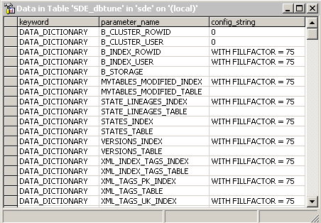
Parameter name–configuration string pairs define the storage configuration of database objects. Parameter names specify what database objects are being configured; the configuration strings define how the objects are configured. They are grouped together by configuration keyword. For example, the parameter name–configuration string pairs of the DATA_DICTIONARY keyword for a SQL Server database are shown below: In the example above, the parameter_name STATES_LINEAGES_INDEX denotes the clustered index on the STATE_LINEAGES system table (the database object). Its associated config_string specifies the index is created with a fill factor of 75 percent (the configuration of the database object).
ArcSDE searches the DBTUNE table for a parameter name–configuration string pair associated with a configuration keyword that matches the configuration keyword specified by the user. If ArcSDE cannot find the requested parameter name–configuration string pair within the specified configuration keyword parameter group or if a configuration keyword was not specified, it searches the DEFAULTS keyword. For example, if you create a raster dataset without specifying a configuration keyword, one of the things ArcSDE will search for is the RAS_STORAGE parameter name–configuration string value associated with the DEFAULTS configuration keyword.
You must use standard parameter name–configuration string pair values; you cannot invent new ones. However, you can alter some of the configuration string values to another standard value.
For example, there is a parameter name under the DEFAULTS keyword for the ArcSDE for Oracle installation—GEOMETRY_STORAGE—that contains a default configuration string value of ST_GEOMETRY. You can change the configuration string value to one of four other values: SDELOB, SDO_GEOMETRY, SDEBINARY, or OGCWKB. See About geometry storage types for more information on what these values mean.
NOTE: The DB2 and Oracle default dbtune files contain several configuration parameters that are commented out with a single number sign (#). You must uncomment them by removing the number sign, then supply the correct table space names for your database. This must be done before you create your geodatabase.
Parameter name–configuration string pairs can be classified into categories. See the DBMS-specific topics listed below for lists and descriptions of the parameters allowed in each database. DB2 DBTUNE configuration parametersInformix DBTUNE configuration parametersOracle DBTUNE configuration parametersPostgreSQL DBTUNE configuration parametersSQL Server DBTUNE configuration parameters