| DBMS |
Description |
|---|
| Oracle |
The ST_Geometry data type is a high-performance storage type provided as part of ArcSDE for Oracle that includes ISO- and OGC-compliant SQL access to geodatabase features. Beginning with the ArcGIS 9.3 release, it is the default feature geometry storage format in new installations of ArcSDE geodatabases for Oracle. |
| IBM DB2 |
The DB2 Spatial Extender, provided by IBM as part of the DB2 product, is the only option used to store feature geometry in geodatabases in DB2. It was codeveloped by ESRI and IBM, is a high-performance storage type that provides ISO- and OGC-compliant SQL access to geodatabase features, and uses the ST_Geometry data type. |
| IBM Informix |
The Informix Spatial DataBlade, provided by IBM as part of the Informix product, is the only option used to store feature geometry in geodatabases in Informix. It was codeveloped by ESRI and IBM, is a high-performance storage type that provides ISO- and OGC-compliant SQL access to geodatabase features, and uses the ST_Geometry data type. |
| PostgreSQL |
The ST_Geometry data type is the default for storing feature geometry in an ArcSDE geodatabase for PostgreSQL. As with the other DBMS implementations, the PostgreSQL implementation provides ISO- and OGC-compliant SQL access to geodatabase features. |
| Subtype |
Description |
Functions used with the subtype |
|---|
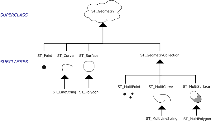
| ST_Point |
- A zero-dimensional geometry that occupies a single location in coordinate space.
- Has a single x,y coordinate value, is always simple, and has a NULL boundary.
- Used to define features such as oil wells, landmarks, and elevations.
|
- ST_X—Returns a point's x-coordinate value as a double-precision number
- ST_Y—Returns a point's y-coordinate value as a double-precision number
- ST_Z—Returns a point's z-coordinate value as a double-precision number
- ST_M—Returns a point's m-coordinate value as a double-precision number
|
| ST_LineString |
- A one-dimensional object stored as a sequence of points defining a linear interpolated path.
- ST_LineStrings have length.
- The ST_LineString is simple if it does not intersect its interior.
- The endpoints (the boundary) of a closed ST_LineString occupy the same point in space.
- An ST_LineString is a ring if it is both closed and simple.
- The endpoints normally form the boundary of an ST_LineString unless the ST_LineString is closed, in which case the boundary is NULL.
- The interior of an ST_LineString is the connected path that lies between the endpoints, unless it is closed, in which case the interior is continuous.
- ST_LineStrings are often used to define linear features such as roads, rivers, and power lines.
|
- ST_StartPoint—Returns the first point of a linestring
- ST_EndPoint—Returns the last point of a linestring
- ST_PointN—Takes a linestring and an index to an nth point and returns that point
- ST_Length—Returns a linestring's length as a double-precision number
- ST_NumPoints—Returns the number of points in a linestring's sequence as an integer
- ST_IsRing—Returns 1 (TRUE) if a linestring is a ring or 0 (FALSE) if it is not
- ST_IsClosed—Returns 1 (TRUE) if a linestring is closed or 0 (FALSE) if it is not
|
| ST_Polygon |
- A two-dimensional surface stored as a sequence of points defining its exterior bounding ring and zero or more interior rings.
- ST_Polygon has area and is always simple.
- The exterior and any interior rings define the boundary of an ST_Polygon, and the space enclosed between the rings defines the ST_Polygon's interior.
- The rings of an ST_Polygon can intersect at a tangent point but never cross.
- Defines parcels of land, water bodies, and other features having spatial extent.
|
- ST_Area—Returns a polygon's area as a double-precision number
- ST_ExteriorRing—Returns a polygon's exterior ring as a linestring
- ST_NumInteriorRing—Returns the number of interior rings a polygon contains
- ST_InteriorRingN—Takes a polygon and an index and returns the nth interior ring as a linestring
- ST_Centroid—Returns a point that is the center of the polygon's envelope
- ST_PointOnSurface—Returns a point that is guaranteed to be on the surface of the polygon
|
| ST_MultiPoint |
- A collection of ST_Points.
- Has a dimension of 0.
- An ST_MultiPoint is simple if none of its elements occupy the same coordinate space.
- The boundary of an ST_MultiPoint is NULL.
- Defines such things as aerial broadcast patterns and incidents of a disease outbreak.
|
|
| ST_MultiLineString |
- A collection of ST_LineStrings.
- ST_MultiLineStrings have length.
- ST_MultiLineStrings are simple if they only intersect at the endpoints of the ST_LineString elements.
- ST_MultiLineStrings are nonsimple if the interiors of the ST_LineString elements intersect.
- The boundary of an ST_MultiLineString is the nonintersected endpoints of the ST_LineString elements.
- The ST_MultiLineString is closed if all its ST_LineString elements are closed.
- The boundary of an ST_MultiLineString is NULL if all the endpoints of all the elements are intersected.
- Used to define entities such as streams or road networks.
|
- ST_Length—Returns the cumulative length of all the ST_LineString elements of a multilinestring as a double-precision number
- ST_IsClosed—Returns 1 (TRUE) if the multilinestring is closed and 0 (FALSE) if it is not
|
| ST_MultiPolygon |
- A collection of polygons.
- ST_MultiPolygons have area.
- The boundary of an ST_MultiPolygon is the cumulative length of its elements' exterior and interior rings.
- The interior of an ST_MultiPolygon is defined as the cumulative interiors of its element ST_Polygons.
- The boundary of an ST_MultiPolygon's elements can only intersect at a tangent point.
- Defines features such as a forest stratum or a noncontiguous parcel of land such as a Pacific island chain.
|
- ST_Area—Returns the cumulative ST_Area of a multipolygon's polygon elements as a double-precision number
- ST_Centroid—Returns a point that is the center of a multipolygon's envelope
- ST_PointOnSurface—Returns a point that is guaranteed to be normal to the surface of one of the multipolygon's polygon elements
|
ArcGIS is designed to work with the ST_Geometry spatial type through ArcSDE. ST_Geometry is the spatial storage type when using ArcSDE for DB2 or ArcSDE for Informix. ArcSDE for PostgreSQL uses the ST_Geometry spatial type by default but also supports the PostGIS spatial type for geometry storage. ArcSDE for Oracle also uses ST_Geometry by default and additionally supports a number of different geometry storage types such as SDELOB, SDO_Geometry, and SDEBINARY. These different schemas can all be used together in the same database. While there can only be one default geometry schema, individual feature classes can be created using different geometry schemas.
ESRI recommends creating feature classes in spatial type format using ArcGIS versus using SQL. This recommendation is based on the following:
- Data that you create or add to your ArcSDE geodatabase using ArcGIS Desktop software is automatically registered with ArcSDE and the geodatabase. All required components are created for you by the software. It can be used immediately by ArcGIS. It can also be used immediately via SQL and other applications.
(An additional registration step is required to enable the feature class for versioning.)
- By default, the spatial index is generated for you. An additional step is not required to create the spatial index.
- Complete tools are available to you for determining and specifying the spatial reference for your data. Many spatial references have already been defined and are available for use. If none of these spatial references represent the projection that is desired, you are able to modify the current projections or create your own. If you want to use the same spatial reference of an existing dataset, you can import that exact spatial reference as well.
If you do not create feature classes in spatial type format using ArcGIS, you must do the following:
- Register the spatial column with ArcSDE.
In geodatabases using the spatial type in DB2, Informix, and Oracle, you can set the SERVER_CONFIG parameter DISABLEAUTOREG to false, thereby enabling the automatic registration of the spatial column by the ArcSDE service. In geodatabases in PostgreSQL that use the spatial type, use the ST_register_spatial_column function to register the ST_Geometry column.
- Create a spatial index on the table. See Creating spatial indexes on tables with an ST_Geometry column for instructions.
- Register the table as a feature class with ArcSDE using the sdelayer –o register command. See the ArcSDE administration command reference for syntax and usage.
- Register the feature class with the geodatabase.
The last two steps are explained in the last section of the topic
Enhancing ArcGIS functionality using spatial types.
Creating a new feature class with ArcGIS
There are four primary ways to create a new feature class in your geodatabase:
- Use ArcCatalog.
- Use the geoprocessing tool Create Feature Class.
- Save the contents of a map layer in ArcMap.
- Convert an external data source into a geodatabase feature class (e.g., convert a shapefile or a computer-aided design [CAD] file). To convert an external data source to a geodatabase feature class, use the import tools in either ArcCatalog or ArcToolbox. There are two ways you can import data: use the context-sensitive menu in ArcCatalog or use the To Geodatabase toolset in ArcToolbox. When you import data that is in a format not used by the geodatabase, ArcGIS automatically converts it into data types used by the geodatabase.
For instructions on how to create a new feature class using ArcGIS, see
Creating feature classes.
When you create new feature classes in a geodatabase in DB2 or Informix, it automatically uses ST_Geometry storage. If you keep the default DBTUNE settings in a geodatabase in Oracle or PostgreSQL, newly created feature classes will also use ST_Geometry storage.
At this stage, you now have a feature class stored in ST_Geometry format. In addition to being ready for use by ArcGIS, the feature class is also available for use via spatial-type SQL operators and functions.