| Adding shapefile data | |
| Adding shapefile data | |
| Related Topics |
|---|
ESRI shapefiles store geographic features and their attribute data in a simple, non-topological vector format. Each shapefile stores features belonging to a single feature class of point, line, or polygon.
A shapefile is actually a set of three constituent files with the same name and different extensions - *.shp, *.shx, and *.dbf. The *.shp file stores the feature geometry. The *.shx file stores the index of the feature geometry. The *.dbf file is a dBASE file that stores the attributes of the features. A shapefile can also include files that store projection or additional indexing information.
|
Use Catalog to add shapefiles to your map.
Layers corresponding to the data you added appear in the legend of your map. | 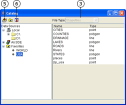 |
Shapefiles cannot be drawn in ArcIMS and are not listed in Catalog when
Refresh Catalog by right-clicking on a folder and clicking Refresh.
 on the Author toolbar to open Catalog.