- Introduction
- SIMPLERENDERER
- GROUPRENDERER
- SIMPLELABELRENDERER
- SCALEDEPENDENTRENDERER
- VALUEMAPRENDERER
- VALUEMAPLABELRENDERER
- RASTER_RENDERER
- A Case Study
Introduction
The ArcXML renderers provide the framework for feature symbolization and labeling. Each ArcXML renderer includes either a symbol or a label, depending on the renderer. Only one symbol or label is allowed within a renderer. In a generalized form, the relationship between a renderer and a symbol in ArcXML is:<RENDERER>
<SYMBOL />
</RENDERER>
The following renderers are available in ArcIMS:
- SIMPLERENDERER
- SIMPLELABELRENDERER
- VALUEMAPRENDERER
- VALUEMAPLABELRENDERER
- GROUPRENDERER
- SCALEDEPENDENTRENDERER
- RASTER_RENDERER
VALUEMAPRENDERER and VALUEMAPLABELRENDERER also have three child elements used to create value maps:
Only one symbol or label can be used inside a renderer, but the renderers can be used in different combinations to create complex symbols. The symbols valid for use with SIMPLERENDERER and VALUEMAPRENDERER are:
- Point layers
- Line layers
- All the symbols valid for point layers
- HASHLINESYMBOL
- SIMPLELINESYMBOL
- Polygon layers
- All the symbols valid for point and line layers
- GRADIENTFILLSYMBOL
- RASTERFILLSYMBOL
- SIMPLEPOLYGONSYMBOL
Symbols valid with SIMPLELABELRENDERER and VALUEMAPLABELRENDERER are:
All renderers are valid with Feature and Image Services. When ArcMap Image Services are used, SIMPLERENDERER is valid when the parent element is LAYERDEF. In addition, symbols can be used in requests to ArcMap Image Services when they are included in acetate layers.
All the examples in this document demonstrate how to use renderers with a map configuration file. The syntax and usage are the same if you want to use the renderers in a request. In the examples below, each renderer is briefly defined, and the examples show how the renderer can be used in a map configuration file. The same concepts can be applied to renderers in requests since the syntax is the same.
The examples used in this document build on the same set of data. Two shapefiles are used: CNTRY94 (polygon) and CITIES (point). Each example is an addition or modification to the previous example.
After each renderer has been described, a section is included covering a case study using a set of shapefiles of New York City. This study is a good example of a map configuration file using all the renderers.
SIMPLERENDERER
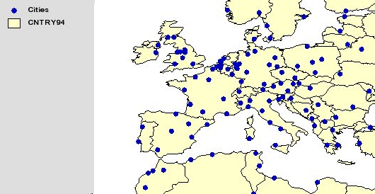
SIMPLERENDERER is used to provide the framework for filling polygons, drawing lines, and displaying points in a layer using one symbol.In the following example, a SIMPLERENDERER is used to describe how polygons in CNTRY94 are drawn. The symbol instructions are inside SIMPLEPOLYGONSYMBOL. In this case, a SIMPLEPOLYGONSYMBOL is used with a solid filltype and a light yellow fillcolor.
Using SIMPLERENDERER
|
<?xml version="1.0" encoding="UTF-8"?> <ARCXML version="1.1"> <CONFIG> <ENVIRONMENT> <LOCALE country="US" language="en" variant="" /> <UIFONT color="0,0,0" name="Arial" size="12" style="regular" /> </ENVIRONMENT> <MAP> <PROPERTIES> <ENVELOPE minx="-180" miny="-90" maxx="180" maxy="90" name="Initial_Extent" /> <MAPUNITS units="decimal_degrees" /> <FILTERCOORDSYS id="4326" /> <FEATURECOORDSYS id="4326"/> </PROPERTIES> <WORKSPACES> <SHAPEWORKSPACE name="shp_ws-0" directory="C:\ESRIDATA\WORLD" /> </WORKSPACES> <LAYER type="featureclass" name="CNTRY94" visible="true" id="1"> <DATASET name="CNTRY94" type="polygon" workspace="shp_ws-0" /> <SIMPLERENDERER> <SIMPLEPOLYGONSYMBOL fillcolor="255,255,204" filltype="solid" /> </SIMPLERENDERER> </LAYER> </MAP> </CONFIG> </ARCXML> |
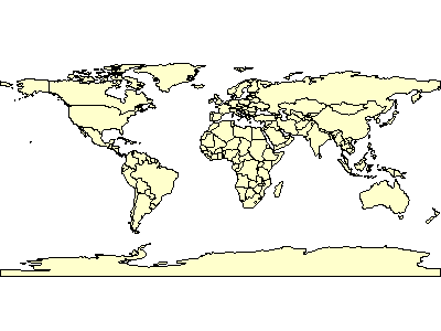
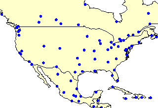
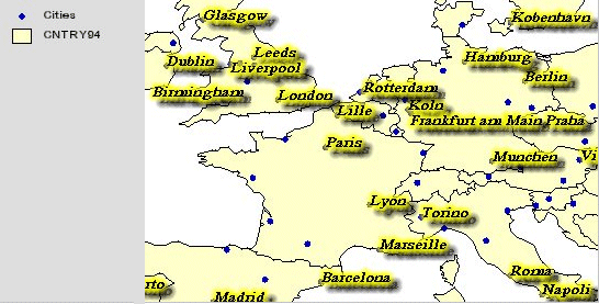
The resulting map shows all countries rendered in light yellow.
|
GROUPRENDERER
GROUPRENDERER is required when two or more renderers are used to describe a layer. For example, if you want to create a multipart symbol, you can use GROUPRENDERER to group together two SIMPLERENDERERS. Another common use for GROUPRENDERER is when both symbols and labels are applied to a layer (discussed in the next section).In the next example, a GROUPRENDERER is used to create a multipart symbol. Inside the GROUPRENDERER are two SIMPLERENDERERS using SIMPLEPOLYGONSYMBOL. The underlying filltype is solid with a cross filltype on top. Note that the renderers and symbols are processed in the order they are read. Since the solid SIMPLEPOLYGONSYMBOL is first, it is the bottom layer.
Using SIMPLERENDERERs inside a GROUPRENDERER
|
<?xml version="1.0" encoding="UTF-8"?> <ARCXML version="1.1"> <CONFIG> <ENVIRONMENT> <LOCALE country="US" language="en" variant="" /> <UIFONT color="0,0,0" name="Arial" size="12" style="regular" /> </ENVIRONMENT> <MAP> <PROPERTIES> <ENVELOPE minx="-180" miny="-90" maxx="180" maxy="90" name="Initial_Extent" /> <MAPUNITS units="decimal_degrees" /> <FILTERCOORDSYS id="4326" /> <FEATURECOORDSYS id="4326"/> </PROPERTIES> <WORKSPACES> <SHAPEWORKSPACE name="shp_ws-0" directory="C:\ESRIDATA\WORLD" /> </WORKSPACES> <LAYER type="featureclass" name="CNTRY94" visible="true" id="1"> <DATASET name="CNTRY94" type="polygon" workspace="shp_ws-0" /> <GROUPRENDERER> <SIMPLERENDERER> <SIMPLEPOLYGONSYMBOL fillcolor="255,255,204" filltype="solid" /> </SIMPLERENDERER> <SIMPLERENDERER> <SIMPLEPOLYGONSYMBOL fillcolor="0,27,127" filltype="cross" /> </SIMPLERENDERER> </GROUPRENDERER> </LAYER> </MAP> </CONFIG> </ARCXML> |
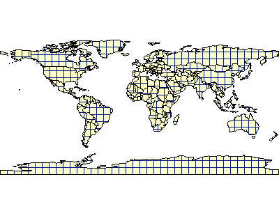
The resulting map shows all countries rendered first in light yellow with a cross pattern on top.
|
SIMPLELABELRENDERER
SIMPLELABELRENDERER is used to label the features in a layer using data from a specified field in the database. In this next example, SIMPLELABELRENDERER is added to the CNTRY94 layer. The field used for labeling is NAME.In order to both label and symbolize a layer, you must use a GROUPRENDERER. The two SIMPLERENDERER elements from the previous example are grouped together along with SIMPLELABELRENDERER using GROUPRENDERER.
Using SIMPLERENDERER and SIMPLELABELRENDERER
|
<?xml version="1.0" encoding="UTF-8"?> <ARCXML version="1.1"> <CONFIG> <ENVIRONMENT> <LOCALE country="US" language="en" variant="" /> <UIFONT color="0,0,0" name="Arial" size="12" style="regular" /> </ENVIRONMENT> <MAP> <PROPERTIES> <ENVELOPE minx="-180" miny="-90" maxx="180" maxy="90" name="Initial_Extent" /> <MAPUNITS units="decimal_degrees" /> <FILTERCOORDSYS id="4326" /> <FEATURECOORDSYS id="4326"/> </PROPERTIES> <WORKSPACES> <SHAPEWORKSPACE name="shp_ws-0" directory="C:\ESRIDATA\WORLD" /> </WORKSPACES> <LAYER type="featureclass" name="CNTRY94" visible="true" id="1"> <DATASET name="CNTRY94" type="polygon" workspace="shp_ws-0" /> <GROUPRENDERER> <SIMPLERENDERER> <SIMPLEPOLYGONSYMBOL fillcolor="255,255,204" filltype="solid" /> </SIMPLERENDERER> <SIMPLERENDERER> <SIMPLEPOLYGONSYMBOL fillcolor="0,27,127" filltype="cross" /> </SIMPLERENDERER> <SIMPLELABELRENDERER field="NAME"> <TEXTSYMBOL fontstyle="bold" fontsize="12" /> </SIMPLELABELRENDERER> </GROUPRENDERER> </LAYER> </MAP> </CONFIG> </ARCXML> |
In the returned map, labels are included as part of the rendering for each country.
|
If you want a layer to be labeled without any symbology, you can do this by including only a SIMPLELABELRENDERER for the layer. In this case you do not need SIMPLERENDERER or GROUPRENDERER. The following example uses only SIMPLELABELRENDERER for the CNTRY94 layer.
Using only SIMPLELABELRENDERER
|
<?xml version="1.0" encoding="UTF-8"?> <ARCXML version="1.1"> <CONFIG> <ENVIRONMENT> <LOCALE country="US" language="en" variant="" /> <UIFONT color="0,0,0" name="Arial" size="12" style="regular" /> </ENVIRONMENT> <MAP> <PROPERTIES> <ENVELOPE minx="-180" miny="-90" maxx="180" maxy="90" name="Initial_Extent" /> <MAPUNITS units="decimal_degrees" /> <FILTERCOORDSYS id="4326" /> <FEATURECOORDSYS id="4326"/> </PROPERTIES> <WORKSPACES> <SHAPEWORKSPACE name="shp_ws-0" directory="C:\ESRIDATA\WORLD" /> </WORKSPACES> <LAYER type="featureclass" name="CNTRY94" visible="true" id="1"> <DATASET name="CNTRY94" type="polygon" workspace="shp_ws-0" /> <SIMPLELABELRENDERER field="NAME"> <TEXTSYMBOL fontstyle="bold" fontsize="12" /> </SIMPLELABELRENDERER> </LAYER> </MAP> </CONFIG> </ARCXML> |
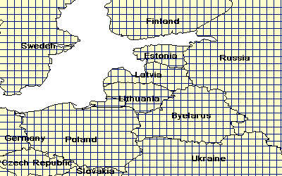
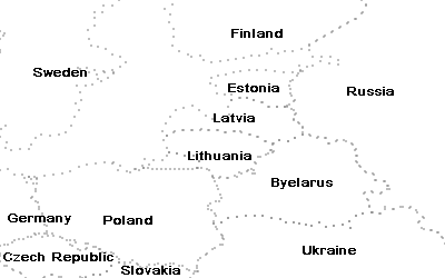
The returned map includes only labels. In the following figure, the country boundaries are included for reference only.
|
SCALEDEPENDENTRENDERER
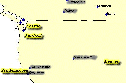
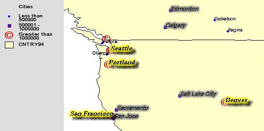
Setting scales for displaying data is a very important part of designing a map configuration file. There are two ways to use scale to control the display of features. The first way is to set a scale factor to turn a layer on and off depending on the scale. The scale factor is set in LAYER using minscale and maxscale attributes. Setting this factor is particularly important for layers with detailed data. In the following example, a Cities layer has been added to the map configuration file. This layer does not display until the scale is less than 1:50000000.The second way to use scale is to use SCALEDEPENDENTRENDERER to change the symbology of a layer when a specified scale is met. The layer always displays, but as you zoom in the symbology changes. For example, in the first SCALEDEPENDENTRENDERER below in the Cities layer, when the scale is between 1:25000000 and 1:50000000, the location of the city is marked with a circle using SIMPLEMARKERSYMBOL inside a SIMPLERENDERER. In the second SCALEDEPENDENTRENDERER, when the scale threshold is less than 1:25000000, the markers change to a larger star.
A third SCALEDEPENDENTRENDERER is used to turn on labeling for Cities when the scale is 1:25000000. TEXTSYMBOL is used inside a SIMPLELABELRENDERER. The three SCALEDEPENDENTRENDERERS must be grouped inside a GROUPRENDERER.
Using SCALEDEPENDENTRENDERER
|
<?xml version="1.0" encoding="UTF-8"?> <ARCXML version="1.1"> <CONFIG> <ENVIRONMENT> <LOCALE country="US" language="en" variant="" /> <UIFONT color="0,0,0" name="Arial" size="12" style="regular" /> </ENVIRONMENT> <MAP> <PROPERTIES> <ENVELOPE minx="-180" miny="-90" maxx="180" maxy="90" name="Initial_Extent" /> <MAPUNITS units="decimal_degrees" /> <FILTERCOORDSYS id="4326" /> <FEATURECOORDSYS id="4326"/> </PROPERTIES> <WORKSPACES> <SHAPEWORKSPACE name="shp_ws-0" directory="C:\ESRIDATA\WORLD" /> </WORKSPACES> <LAYER type="featureclass" name="CNTRY94" visible="true" id="1"> <DATASET name="CNTRY94" type="polygon" workspace="shp_ws-0" /> <SIMPLERENDERER> <SIMPLEPOLYGONSYMBOL fillcolor="255,255,204" filltype="solid" /> </SIMPLERENDERER> </LAYER> <LAYER type="featureclass" name="Cities" visible="true" id="2" maxscale="1:50000000"> <DATASET name="CITIES" type="point" workspace="shp_ws-0" /> <GROUPRENDERER> <SCALEDEPENDENTRENDERER lower="1:25000000" upper="1:50000000"> <SIMPLERENDERER> <SIMPLEMARKERSYMBOL color="0,0,255" width="8" type="circle" /> </SIMPLERENDERER> </SCALEDEPENDENTRENDERER> <SCALEDEPENDENTRENDERER upper="1:25000000"> <SIMPLERENDERER> <SIMPLEMARKERSYMBOL color="0,255,255" width="16" type="star" /> </SIMPLERENDERER> </SCALEDEPENDENTRENDERER> <SCALEDEPENDENTRENDERER upper="1:25000000"> <SIMPLELABELRENDERER field="NAME"> <TEXTSYMBOL fontstyle="regular" fontsize="10" /> </SIMPLELABELRENDERER> </SCALEDEPENDENTRENDERER> </GROUPRENDERER> </LAYER> </MAP> </CONFIG> </ARCXML> |
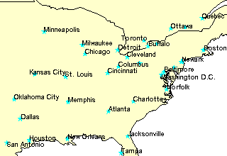
The following figures show a map at two different scales. The map on the left is 1:50000000 and shows each city with a circle. The map on the right is at 1:25000000 and shows each city with a star and label.
|
|
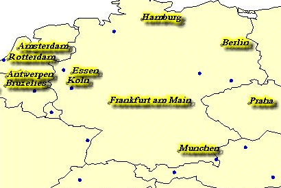
VALUEMAPRENDERER
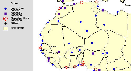
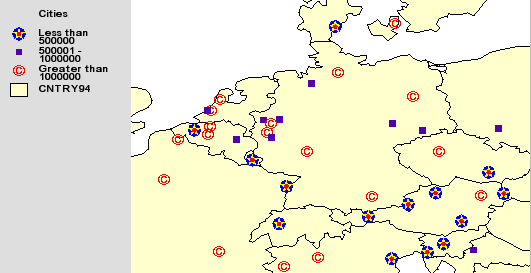
VALUEMAPRENDERER is used to classify features in a layer according to values in a specified field in the database. Based on this field, features in different classifications can be rendered differently. Value maps can be categorized using:- RANGE for graduated symbols maps. With RANGE, a range of values is used to define the category.
- EXACT for unique symbols maps. With EXACT, the values in the specified field must match exactly.
- OTHER, for features that do not fit in any other RANGE or EXACT category. OTHER is optional to use in a value map and, if it is not used, symbols that do not fall into one of the categories are not drawn.
The first RANGE category is for cities with fewer than 500,000 in population and uses a circle for the SIMPLEMARKERSYMBOL. The second RANGE category is for a population between 500,000 and 1,000,000 and uses a square marker. The third RANGE category is for a population greater than 1,000,000, and the marker for this category is a TRUETYPEMARKERSYMBOL.
Using VALUEMAPRENDERER
|
<?xml version="1.0" encoding="UTF-8"?> <ARCXML version="1.1"> <CONFIG> <ENVIRONMENT> <LOCALE country="US" language="en" variant="" /> <UIFONT color="0,0,0" name="Arial" size="12" style="regular" /> </ENVIRONMENT> <MAP> <PROPERTIES> <ENVELOPE minx="-180" miny="-90" maxx="180" maxy="90" name="Initial_Extent" /> <MAPUNITS units="decimal_degrees" /> <FILTERCOORDSYS id="4326" /> <FEATURECOORDSYS id="4326"/> </PROPERTIES> <WORKSPACES> <SHAPEWORKSPACE name="shp_ws-6" directory="C:\ESRIDATA\WORLD" /> </WORKSPACES> <LAYER type="featureclass" name="CNTRY94" visible="true" id="0"> <DATASET name="CNTRY94" type="polygon" workspace="shp_ws-6" /> <SIMPLERENDERER> <SIMPLEPOLYGONSYMBOL fillcolor="255,255,204" filltype="solid" /> </SIMPLERENDERER> </LAYER> <LAYER type="featureclass" name="Cities" visible="true" id="1" maxscale="1:50000000"> <DATASET name="CITIES" type="point" workspace="shp_ws-6" /> <VALUEMAPRENDERER lookupfield="POPULATION"> <RANGE lower="0" upper="500000" label="Less than 500000"> <SIMPLEMARKERSYMBOL color="0,0,255" width="8" type="circle" /> </RANGE> <RANGE lower="500001" upper="1000000" label="500001 - 1000000"> <SIMPLEMARKERSYMBOL color="85,0,170" width="8" type="square" /> </RANGE> <RANGE lower="1000001" upper="23620001" label="Greater than 1000000"> <TRUETYPEMARKERSYMBOL fontstyle="regular" character="169" font="Arial" fontcolor="255,0,0" fontsize="20" /> </RANGE> <OTHER> <SIMPLEMARKERSYMBOL width="8" /> </OTHER> </VALUEMAPRENDERER> </LAYER> </MAP> </CONFIG> </ARCXML> |
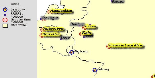
The resulting map shows the three categories of cities based on population.
|
If you wish to display only a subset of features from a layer, use SPATIALQUERY rather than a VALUEMAPRENDERER whenever possible for performance reasons. For example, suppose at the full extent of the map, you want to display only major roads, which is only a small fraction of the number of roads in the layer. You could use a VALUEMAPRENDERER and display only these roads. However, in order for the Spatial Server to render this layer, it must still search through every record in the layer before drawing the features. This process can be time consuming. However, if you use a SPATIALQUERY, a filter is set on the layer, and the Spatial Server processes only those features within the filter.
Creating multipart symbols
Multipart symbols can be created for one or more categories of a value map. To do this, additional VALUEMAPRENDERERs are used with only the RANGE or EXACT categories you are interested in. In the next example, the marker for cities with a population less than 500,000 is a three-part symbol:- The base part is a large blue circle.
- The middle part is a yellow star.
- The top part is a small red circle.
Using VALUEMAPRENDERER to create a multipart symbol
|
<?xml version="1.0" encoding="UTF-8"?> <ARCXML version="1.1"> <CONFIG> <ENVIRONMENT> <LOCALE country="US" language="en" variant="" /> <UIFONT color="0,0,0" name="Arial" size="12" style="regular" /> </ENVIRONMENT> <MAP> <PROPERTIES> <ENVELOPE minx="-180" miny="-90" maxx="180" maxy="90" name="Initial_Extent" /> <MAPUNITS units="decimal_degrees" /> <FILTERCOORDSYS id="4326" /> <FEATURECOORDSYS id="4326"/> </PROPERTIES> <WORKSPACES> <SHAPEWORKSPACE name="shp_ws-6" directory="C:\ESRIDATA\WORLD" /> </WORKSPACES> <LAYER type="featureclass" name="CNTRY94" visible="true" id="0"> <DATASET name="CNTRY94" type="polygon" workspace="shp_ws-6" /> <SIMPLERENDERER> <SIMPLEPOLYGONSYMBOL fillcolor="255,255,204" filltype="solid" /> </SIMPLERENDERER> </LAYER> <LAYER type="featureclass" name="Cities" visible="true" id="1" maxscale="1:50000000"> <DATASET name="CITIES" type="point" workspace="shp_ws-6" /> <GROUPRENDERER> <VALUEMAPRENDERER lookupfield="POPULATION"> <RANGE lower="0" upper="500000" label="Less than 500000"> <!--blue circle--> <SIMPLEMARKERSYMBOL color="0,0,255" width="16" type="circle" /> </RANGE> <RANGE lower="500001" upper="1000000" label="500001 - 1000000"> <SIMPLEMARKERSYMBOL color="85,0,170" width="7" type="square" /> </RANGE> <RANGE lower="1000001" upper="23620001" label="Greater than 1000000"> <TRUETYPEMARKERSYMBOL fontstyle="regular" character="169" font="Arial" fontcolor="255,0,0" fontsize="20" /> </RANGE> </VALUEMAPRENDERER> <VALUEMAPRENDERER lookupfield="POPULATION"> <RANGE lower="0" upper="500000" label="Less than 500000"> <!--yellow star--> <SIMPLEMARKERSYMBOL color="255,255,0" width="16" type="star" /> </RANGE> </VALUEMAPRENDERER> <VALUEMAPRENDERER lookupfield="POPULATION"> <RANGE lower="0" upper="500000" label="Less than 500000"> <!--red circle--> <SIMPLEMARKERSYMBOL color="255,0,0" width="4" type="circle" /> </RANGE> </VALUEMAPRENDERER> </GROUPRENDERER> </LAYER> </MAP> </CONFIG> </ARCXML> |
The resulting map shows cities with a multipart symbol for cities with a population less than 500,000 plus the two additional categories of cities between 500,000 and 1,000,000 and cities greater than 1,000,000.
|
VALUEMAPRENDERER inside a SCALEDEPENDENTRENDERER
A VALUEMAPRENDERER can be used inside of a SCALEDEPENDENTRENDERER. In the following example, the Cities layer is divided into two SCALEDEPENDENTRENDERERs. When the scale is between 1:25000000 and 1:50000000, all cities are rendered with a blue circle using a SIMPLERENDERER. When the scale is less than 1:25000000, the value map from the previous example is used for rendering each city based on population. GROUPRENDERER is used around both SCALEDEPENDENTRENDERER elements and to group the VALUEMAPRENDERER elements.Using VALUEMAPRENDERER inside a SCALEDEPENDENTRENDERER
|
<?xml version="1.0" encoding="UTF-8"?> <ARCXML version="1.1"> <CONFIG> <ENVIRONMENT> <LOCALE country="US" language="en" variant="" /> <UIFONT color="0,0,0" name="Arial" size="12" style="regular" /> </ENVIRONMENT> <MAP> <PROPERTIES> <ENVELOPE minx="-180" miny="-90" maxx="180" maxy="90" name="Initial_Extent" /> <MAPUNITS units="decimal_degrees" /> <FILTERCOORDSYS id="4326" /> <FEATURECOORDSYS id="4326"/> </PROPERTIES> <WORKSPACES> <SHAPEWORKSPACE name="shp_ws-6" directory="C:\ESRIDATA\WORLD" /> </WORKSPACES> <LAYER type="featureclass" name="CNTRY94" visible="true" id="0"> <DATASET name="CNTRY94" type="polygon" workspace="shp_ws-6" /> <SIMPLERENDERER> <SIMPLEPOLYGONSYMBOL fillcolor="255,255,204" filltype="solid" /> </SIMPLERENDERER> </LAYER> <LAYER type="featureclass" name="Cities" visible="true" id="1" maxscale="1:50000000"> <DATASET name="CITIES" type="point" workspace="shp_ws-6" /> <GROUPRENDERER> <SCALEDEPENDENTRENDERER lower="1:25000000" > <SIMPLERENDERER> <SIMPLEMARKERSYMBOL color="0,0,190" width="8" type="circle" /> </SIMPLERENDERER> </SCALEDEPENDENTRENDERER> <SCALEDEPENDENTRENDERER upper="1:25000000" > <GROUPRENDERER> <VALUEMAPRENDERER lookupfield="POPULATION"> <RANGE lower="0" upper="500000" label="Less than 500000"> <SIMPLEMARKERSYMBOL color="0,0,255" width="16" type="circle" /> </RANGE> <RANGE lower="500001" upper="1000000" label="500001 - 1000000"> <SIMPLEMARKERSYMBOL color="85,0,170" width="7" type="square" /> </RANGE> <RANGE lower="1000001" upper="23620001" label="Greater than 1000000"> <TRUETYPEMARKERSYMBOL fontstyle="regular" character="169" font="Arial" fontcolor="255,0,0" fontsize="20" /> </RANGE> </VALUEMAPRENDERER> <VALUEMAPRENDERER lookupfield="POPULATION"> <RANGE lower="0" upper="500000" label="Less than 500000"> <SIMPLEMARKERSYMBOL color="255,255,0" width="16" type="star" /> </RANGE> </VALUEMAPRENDERER> <VALUEMAPRENDERER lookupfield="POPULATION"> <RANGE lower="0" upper="500000" label="Less than 500000"> <SIMPLEMARKERSYMBOL color="255,0,0" width="4" type="circle" /> </RANGE> </VALUEMAPRENDERER> </GROUPRENDERER> </SCALEDEPENDENTRENDERER> </GROUPRENDERER> </LAYER> </MAP> </CONFIG> </ARCXML> |
The following two figures show the same map at two scales. The first map is at 1:30000000 and shows all cities with a small circle. The second map is at 1:12000000 and symbolizes cities based on population.
|
|
|
VALUEMAPLABELRENDERER
VALUEMAPLABELRENDERER applies label formats based on different classifications in a field in a database. Labels can be categorized using RANGE, EXACT, or OTHER, similar to VALUEMAPRENDERER for feature symbolization.In the following example, the Cities layer (which does not display until the scale is less than 1:50000000) is labeled based on three RANGEs. The RANGEs are cities with a population less than 500,000, a population of 500,000 to 1,000,000, and a population greater than 1,000,000. For each category, TEXTSYMBOL is used, but instructions for labeling are different. Small cities use the Tahoma font. Medium-sized cities use an italic Arial font with glow. Large cities use a bold italic Times New Roman font with glow and shadow.
All cities are rendered with a circle using SIMPLEMARKERSYMBOL inside a SIMPLERENDERER. Both the SIMPLERENDERER and VALUEMAPLABELRENDERER are grouped inside a GROUPRENDERER.
Using VALUEMAPLABELRENDERER
|
<?xml version="1.0" encoding="UTF-8"?> <ARCXML version="1.1"> <CONFIG> <ENVIRONMENT> <LOCALE country="US" language="en" variant="" /> <UIFONT color="0,0,0" name="Arial" size="12" style="regular" /> </ENVIRONMENT> <MAP> <PROPERTIES> <ENVELOPE minx="-180" miny="-90" maxx="180" maxy="90" name="Initial_Extent" /> <MAPUNITS units="decimal_degrees" /> <FILTERCOORDSYS id="4326" /> <FEATURECOORDSYS id="4326"/> </PROPERTIES> <WORKSPACES> <SHAPEWORKSPACE name="shp_ws-6" directory="C:\ESRIDATA\WORLD" /> </WORKSPACES> <LAYER type="featureclass" name="CNTRY94" visible="true" id="0"> <DATASET name="CNTRY94" type="polygon" workspace="shp_ws-6" /> <SIMPLERENDERER> <SIMPLEPOLYGONSYMBOL fillcolor="255,255,204" filltype="solid" /> </SIMPLERENDERER> </LAYER> <LAYER type="featureclass" name="Cities" visible="true" id="1" maxscale="1:50000000"> <DATASET name="CITIES" type="point" workspace="shp_ws-6" /> <GROUPRENDERER> <SIMPLERENDERER> <SIMPLEMARKERSYMBOL color="0,0,190" width="8" type="circle" /> </SIMPLERENDERER> <VALUEMAPLABELRENDERER lookupfield="POPULATION" labelfield="NAME" > <RANGE lower="0" upper="500000" > <TEXTSYMBOL font="Tahoma" fontstyle="regular" fontsize="10" /> </RANGE> <RANGE lower="500001" upper="1000000" > <TEXTSYMBOL font="Arial" fontstyle="italic" fontsize="12" glowing="125,125,125" /> </RANGE> <RANGE lower="1000001" upper="23620001" > <TEXTSYMBOL font="Times New Roman" fontstyle="bolditalic" fontsize="14" glowing="255,255,0" shadow="0,0,0" /> </RANGE> </VALUEMAPLABELRENDERER> </GROUPRENDERER> </LAYER> </MAP> </CONFIG> </ARCXML> |
In the resulting map, all cities are identified by a blue marker. Based on the population of the city, one of three label formats is used.
|
Using VALUEMAPRENDERER and VALUEMAPLABELRENDERER together
VALUEMAPRENDERER and VALUEMAPLABELRENDERER can be used within the same GROUPRENDERER. In the next example, VALUEMAPRENDERER replaces the SIMPLERENDERER information for the Cities layer. The following symbology and labels are used based on city population:| City Population Range | Symbol | Label |
|---|---|---|
| Less than 500,000 | Circle | Tahoma font |
| 500,000 to 1,000,000 | Square | Italic Arial font with glow |
| Greater than 1,000,000 | TrueType symbol | Bold italic Times New Roman font with glow and shadow |
Using VALUEMAPRENDERER and VALUEMAPLABELRENDERER together
|
<?xml version="1.0" encoding="UTF-8"?> <ARCXML version="1.1"> <CONFIG> <ENVIRONMENT> <LOCALE country="US" language="en" variant="" /> <UIFONT color="0,0,0" name="Arial" size="12" style="regular" /> </ENVIRONMENT> <MAP> <PROPERTIES> <ENVELOPE minx="-180" miny="-90" maxx="180" maxy="90" name="Initial_Extent" /> <MAPUNITS units="decimal_degrees" /> <FILTERCOORDSYS id="4326" /> <FEATURECOORDSYS id="4326"/> </PROPERTIES> <WORKSPACES> <SHAPEWORKSPACE name="shp_ws-6" directory="C:\ESRIDATA\WORLD" /> </WORKSPACES> <LAYER type="featureclass" name="CNTRY94" visible="true" id="0"> <DATASET name="CNTRY94" type="polygon" workspace="shp_ws-6" /> <SIMPLERENDERER> <SIMPLEPOLYGONSYMBOL filltransparency="1.0" fillcolor="255,255,204" /> </SIMPLERENDERER> </LAYER> <LAYER type="featureclass" name="Cities" visible="true" id="1" maxscale="1:50000000"> <DATASET name="CITIES" type="point" workspace="shp_ws-6" /> <GROUPRENDERER> <VALUEMAPRENDERER lookupfield="POPULATION"> <RANGE lower="0" upper="500000" label="Less than 500000"> <SIMPLEMARKERSYMBOL color="0,0,255" width="5" type="circle" /> </RANGE> <RANGE lower="500001" upper="1000000" label="500001 - 1000000"> <SIMPLEMARKERSYMBOL color="85,0,170" width="7" type="square" /> </RANGE> <RANGE lower="1000001" upper="23620001" label="Greater than 1000000"> <TRUETYPEMARKERSYMBOL fontstyle="regular" character="169" font="Arial" fontcolor="255,0,0" fontsize="20" /> </RANGE> </VALUEMAPRENDERER> <VALUEMAPLABELRENDERER lookupfield="POPULATION" labelfield="NAME" > <RANGE lower="0" upper="500000" > <TEXTSYMBOL font="Tahoma" fontstyle="regular" fontsize="10" /> </RANGE> <RANGE lower="500001" upper="1000000" > <TEXTSYMBOL font="Arial" fontstyle="italic" fontsize="12" glowing="125,125,125" /> </RANGE> <RANGE lower="1000001" upper="23620001" > <TEXTSYMBOL font="Times New Roman" fontstyle="bolditalic" fontsize="14" glowing="255,255,0" shadow="0,0,0" /> </RANGE> </VALUEMAPLABELRENDERER> </GROUPRENDERER> </LAYER> </MAP> </CONFIG> </ARCXML> |
In the resulting map, the marker and label assigned to each city are based on the population.
|
Limiting labels to a subgroup of features
VALUEMAPLABELRENDERER can also be used to limit labeling to a subgroup of features. In the next example, only cities with a population greater than 1000000 are labeled. To do this, only one RANGE category is used inside the VALUEMAPLABELRENDERER. If a city's population does not fall within this range, then it is not labeled.Using VALUEMAPLABELRENDERER to label a subgroup of features
|
<?xml version="1.0" encoding="UTF-8"?> <ARCXML version="1.1"> <CONFIG> <ENVIRONMENT> <LOCALE country="US" language="en" variant="" /> <UIFONT color="0,0,0" name="Arial" size="12" style="regular" /> </ENVIRONMENT> <MAP> <PROPERTIES> <ENVELOPE minx="-180" miny="-90" maxx="180" maxy="90" name="Initial_Extent" /> <MAPUNITS units="decimal_degrees" /> <FILTERCOORDSYS id="4326" /> <FEATURECOORDSYS id="4326"/> </PROPERTIES> <WORKSPACES> <SHAPEWORKSPACE name="shp_ws-6" directory="C:\ESRIDATA\WORLD" /> </WORKSPACES> <LAYER type="featureclass" name="CNTRY94" visible="true" id="0"> <DATASET name="CNTRY94" type="polygon" workspace="shp_ws-6" /> <SIMPLERENDERER> <SIMPLEPOLYGONSYMBOL fillcolor="255,255,204" filltype="solid" /> </SIMPLERENDERER> </LAYER> <LAYER type="featureclass" name="Cities" visible="true" id="1" maxscale="1:50000000"> <DATASET name="CITIES" type="point" workspace="shp_ws-6" /> <GROUPRENDERER> <SIMPLERENDERER> <SIMPLEMARKERSYMBOL color="0,0,190" width="6" type="circle" /> </SIMPLERENDERER> <VALUEMAPLABELRENDERER lookupfield="POPULATION" labelfield="NAME" > <RANGE lower="1000000" upper="23620001" > <TEXTSYMBOL font="Times New Roman" fontstyle="bolditalic" fontsize="14" glowing="255,255,0" shadow="0,0,0" /> </RANGE> </VALUEMAPLABELRENDERER> </GROUPRENDERER> </LAYER> </MAP> </CONFIG> </ARCXML> |
In the resulting map, only cities with a population greater than 1000000 are labeled.
|
VALUEMAPLABELRENDERER inside a SCALEDEPENDENTRENDERER
VALUEMAPLABELRENDERER can be used inside a SCALEDEPENDENTRENDERER. In the next example, only cities with a population greater than 1000000 are labeled when the scale is between 1:25000000 and 1:50000000. When the scale is less than 1:25000000, all cities are labeled according to their population. A GROUPRENDERER is used around the two SCALEDEPENDENTRENDERER elements.The following table summarizes the labels used at different scales:
| City Population Range | Label |
|---|---|
| When scale is greater than 1:25000000: | |
| Greater than 1,000,000 | Bold italic Times New Roman font with Glow and Shadow |
| When scale is less than 1:25000000: | |
| Less than 500,000 | Tahoma font |
| 500,000 to 1,000,000 | Italic Arial font with glow |
| Greater than 1,000,000 | Bold italic Times New Roman font with Glow and Shadow |
Using VALUEMAPLABELRENDERER inside a SCALEDEPENDENTRENDERER
|
<?xml version="1.0" encoding="UTF-8"?> <ARCXML version="1.1"> <CONFIG> <ENVIRONMENT> <LOCALE country="US" language="en" variant="" /> <UIFONT color="0,0,0" name="Arial" size="12" style="regular" /> </ENVIRONMENT> <MAP> <PROPERTIES> <ENVELOPE minx="-180" miny="-90" maxx="180" maxy="90" name="Initial_Extent" /> <MAPUNITS units="decimal_degrees" /> <FILTERCOORDSYS id="4326" /> <FEATURECOORDSYS id="4326"/> </PROPERTIES> <WORKSPACES> <SHAPEWORKSPACE name="shp_ws-6" directory="C:\ESRIDATA\WORLD" /> </WORKSPACES> <LAYER type="featureclass" name="CNTRY94" visible="true" id="0"> <DATASET name="CNTRY94" type="polygon" workspace="shp_ws-6" /> <SIMPLERENDERER> <SIMPLEPOLYGONSYMBOL fillcolor="255,255,204" filltype="solid" /> </SIMPLERENDERER> </LAYER> <LAYER type="featureclass" name="Cities" visible="true" id="1" maxscale="1:50000000"> <DATASET name="CITIES" type="point" workspace="shp_ws-6" /> <GROUPRENDERER> <!--Around all renderers--> <SCALEDEPENDENTRENDERER lower="1:25000000" > <!--labeling and rendering when the scale is greater than 1:25000000--> <GROUPRENDERER> <SIMPLERENDERER> <SIMPLEMARKERSYMBOL color="0,0,190" width="6" type="circle" /> </SIMPLERENDERER> <!--Only label cities with population greater than 1,000,000--> <VALUEMAPLABELRENDERER lookupfield="POPULATION" labelfield="NAME" > <RANGE lower="1000001" upper="23620001" > <TEXTSYMBOL font="Times New Roman" fontstyle="bold" fontsize="14" glowing="255,255,0" shadow="0,0,0" /> </RANGE> </VALUEMAPLABELRENDERER> </GROUPRENDERER> </SCALEDEPENDENTRENDERER> <SCALEDEPENDENTRENDERER upper="1:25000000" ><!--Labeling and rendering when the scale is less than 1:25000000--> <GROUPRENDERER> <!--Render cities based on population--> <VALUEMAPRENDERER lookupfield="POPULATION"> <RANGE lower="0" upper="500000" label="Less than 500000"> <SIMPLEMARKERSYMBOL color="0,0,255" width="16" type="circle" /> </RANGE> <RANGE lower="500001" upper="1000000" label="500001 - 1000000"> <SIMPLEMARKERSYMBOL color="85,0,170" width="7" type="square" /> </RANGE> <RANGE lower="1000001" upper="23620001" label="Greater than 1000000"> <TRUETYPEMARKERSYMBOL fontstyle="regular" character="169" font="Arial" fontcolor="255,0,0" fontsize="20" /> </RANGE> </VALUEMAPRENDERER> <VALUEMAPRENDERER lookupfield="POPULATION"> <RANGE lower="0" upper="500000" label="Less than 500000"> <SIMPLEMARKERSYMBOL color="255,255,0" width="16" type="star" /> </RANGE> </VALUEMAPRENDERER> <VALUEMAPRENDERER lookupfield="POPULATION"> <RANGE lower="0" upper="500000" label="Less than 500000"> <SIMPLEMARKERSYMBOL color="255,0,0" width="4" type="circle" /> </RANGE> </VALUEMAPRENDERER> <!--Label all cities based on population--> <VALUEMAPLABELRENDERER lookupfield="POPULATION" labelfield="NAME" > <RANGE lower="0" upper="500000" > <TEXTSYMBOL font="Tahoma" fontstyle="regular" fontsize="10" /> </RANGE> <RANGE lower="500001" upper="1000000" > <TEXTSYMBOL font="Arial" fontstyle="italic" fontsize="12" glowing="125,125,125" /> </RANGE> <RANGE lower="1000001" upper="23620001" > <TEXTSYMBOL font="Times New Roman" fontstyle="bolditalic" fontsize="14" glowing="255,255,0" shadow="0,0,0" /> </RANGE> </VALUEMAPLABELRENDERER> </GROUPRENDERER> </SCALEDEPENDENTRENDERER> </GROUPRENDERER> </LAYER> </MAP> </CONFIG> </ARCXML> |
The following two figures are the same map at two scales. The scale for the first map is 1:40000000. At this scale, only cities with a population greater than 1,000,000 are labeled. The scale for the second map is 1:8000000. All cities are labeled based on population.
|
|
RASTER_RENDERER
The RASTER_RENDERER elements are used to classify pixel values in a raster layer. The elements are valid only in map configuration files and Image Services. They are not valid in Feature or ArcMap Image Services, nor can they be used in a request. The list of elements includes: RASTER_RENDERER is supported with the following formats: ArcSDE Raster, BIL, BMP, BSQ, CIB, GIF, GIS, GRID, IMG, JPEG, LAN, GEOTIFF, TIFF, and IMPELL. Only single band rasters are supported - the raster cannot be multiband.RASTER_RENDERER can be used in place of an ArcSDE colormap or CLR file, which pairs a value and a color. The value is included in the legend. Supported formats are ArcSDE raster, GRID, BIL, and BSQ. Another option is a table in ArcSDE that pairs a value with a color and description. In this case, the description is included in the legend. If no description is available, the value is used instead. If this table is used, the colormap is ignored. If the RASTER_RENDERER elements are used, any colormaps or ArcSDE tables are ignored.
A Case Study
The following case study uses New York City street data to apply a combination of renderers for displaying these roads with different rendering at different scales. The map configuration file is shown here in its entirety. Take a look at this file to get a general overview. Each of the layers is discussed below.Entire map configuration file
|
<?xml version="1.0" encoding="UTF-8"?> <ARCXML version="1.1"> <CONFIG> <ENVIRONMENT> <LOCALE country="US" language="en" variant="" /> <UIFONT color="0,0,0" name="Arial" size="12" style="regular" /> </ENVIRONMENT> <MAP> <PROPERTIES> <ENVELOPE minx="-74.066" miny="40.689" maxx="-73.823" maxy="40.883" name="Initial_Extent" /> <MAPUNITS units="decimal_degrees" /> <FILTERCOORDSYS id="4326" /> <FEATURECOORDSYS id="4326"/> </PROPERTIES> <WORKSPACES> <SHAPEWORKSPACE name="shp_ws-0" directory="c:\nycity\data" /> </WORKSPACES> <LAYER type="featureclass" name="Background" visible="true" id="0" > <DATASET name="nyc_back" type="polygon" workspace="shp_ws-0" /> <SIMPLERENDERER> <SIMPLEPOLYGONSYMBOL fillcolor="145,239,254" filltype="solid" /> </SIMPLERENDERER> </LAYER> <LAYER type="featureclass" name="City Limits" visible="true" id="1" > <DATASET name="nyc_bound" type="polygon" workspace="shp_ws-0" /> <SIMPLERENDERER> <SIMPLEPOLYGONSYMBOL fillcolor="255,249,165" filltype="solid" /> </SIMPLERENDERER> </LAYER> <LAYER type="featureclass" name="Parks" visible="true" id="2" > <DATASET name="nyc_parks" type="polygon" workspace="shp_ws-0" /> <SIMPLERENDERER> <SIMPLEPOLYGONSYMBOL fillcolor="135,184,114" filltype="solid" /> </SIMPLERENDERER> </LAYER> <LAYER type="featureclass" name="Water" visible="true" id="3" > <DATASET name="nyc_water" type="polygon" workspace="shp_ws-0" /> <SIMPLERENDERER> <SIMPLEPOLYGONSYMBOL fillcolor="145,239,254" filltype="solid" /> </SIMPLERENDERER> </LAYER> <LAYER type="featureclass" name="Roads" visible="true" id="4" maxscale="1:35000"> <DATASET name="nyc_roads" type="line" workspace="shp_ws-0" /> <GROUPRENDERER> <SCALEDEPENDENTRENDERER lower="1:21300" > <VALUEMAPRENDERER lookupfield="ROAD_TYPE"> <EXACT value="Freeway"> <SIMPLELINESYMBOL type="solid" width="3" color="255,0,0" /> </EXACT> <EXACT value="Street"> <SIMPLELINESYMBOL type="solid" width="1" color="0,0,255" /> </EXACT> </VALUEMAPRENDERER> </SCALEDEPENDENTRENDERER> <SCALEDEPENDENTRENDERER upper="1:21300"> <GROUPRENDERER> <VALUEMAPRENDERER lookupfield="ROAD_TYPE"> <EXACT value="Freeway"> <SIMPLELINESYMBOL type="solid" width="9" color="0,0,0" /> </EXACT> <EXACT value="Street"> <SIMPLELINESYMBOL type="solid" width="8" color="255,255,255" /> </EXACT> </VALUEMAPRENDERER> <VALUEMAPRENDERER lookupfield="ROAD_TYPE"> <EXACT value="Freeway"> <SIMPLELINESYMBOL type="solid" width="7" color="255,0,0" /> </EXACT> </VALUEMAPRENDERER> <VALUEMAPRENDERER lookupfield="ROAD_TYPE"> <EXACT value="Freeway"> <SIMPLELINESYMBOL type="solid" width="3" color="0,0,0" /> </EXACT> </VALUEMAPRENDERER> <VALUEMAPRENDERER lookupfield="ROAD_TYPE"> <EXACT value="Freeway"> <SIMPLELINESYMBOL type="solid" width="1" color="255,255,255" /> </EXACT> </VALUEMAPRENDERER> </GROUPRENDERER> </SCALEDEPENDENTRENDERER> <SCALEDEPENDENTRENDERER upper="1:25000"> <VALUEMAPLABELRENDERER lookupfield="ROAD_TYPE" labelfield="NAME" linelabelposition="placeontop" howmanylabels="One_label_per_name"> <EXACT value="Freeway"> <TEXTSYMBOL font="Arial" fontsize="14" fontstyle="bold" fontcolor="0,0,255" glowing="153,153,153"/> </EXACT> <EXACT value="Street"> <TEXTSYMBOL font="Arial" fontsize="14" fontstyle="bold" fontcolor="0,0,0" /> </EXACT> </VALUEMAPLABELRENDERER> </SCALEDEPENDENTRENDERER> </GROUPRENDERER> </LAYER> <LAYER type="featureclass" name="Roads" visible="true" id="5" minscale="1:35000"> <DATASET name="nyc_mainroads" type="line" workspace="shp_ws-0" /> <GROUPRENDERER> <VALUEMAPRENDERER lookupfield="ROAD_TYPE"> <EXACT value="Freeway"> <SIMPLELINESYMBOL type="solid" width="4" color="0,0,0" /> </EXACT> <EXACT value="Secondary"> <SIMPLELINESYMBOL type="solid" width="1" color="0,0,255" /> </EXACT> <EXACT value="Primary"> <SIMPLELINESYMBOL type="solid" width="1" color="255,0,0" /> </EXACT> </VALUEMAPRENDERER> <VALUEMAPRENDERER lookupfield="ROAD_TYPE"> <EXACT value="Freeway"> <SIMPLELINESYMBOL type="solid" width="2" color="255,0,0" /> </EXACT> </VALUEMAPRENDERER> </GROUPRENDERER> </LAYER> </MAP> </CONFIG> </ARCXML> |
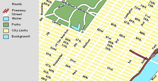
The following three figures show the New York City roads displayed at different scales. Depending on the scale, the street and freeway symbols change. The first map is at 1:200000, the second is at 1:30000, and the third is at 1:20000.
|
|
|
There are six layers in this map configuration file. Each of the layers has been assigned an alias name as shown in the following table. The alias names are what appear in the legend.
| Layer Alias Name as Seen in Legend | Shapefile Name |
|---|---|
| Background | nyc_back |
| City Limits | nyc_bound |
| Parks | nyc_parks |
| Water | nyc_water |
| Roads | nyc_roads |
| Roads | nyc_mainroads |
Nyc_back, nyc_bound, nyc_parks, nyc_water layers
Nyc_back, nyc_bound, nyc_parks, and nyc_water use SIMPLEPOLYGON inside a SIMPLERENDERER. The nyc_back layer is shown here as an example.Nyc_back Layer
|
<LAYER type="featureclass" name="Background" visible="true" id="0" > <DATASET name="nyc_back" type="polygon" workspace="shp_ws-0" /> <SIMPLERENDERER> <SIMPLEPOLYGONSYMBOL fillcolor="145,239,254" filltype="solid" /> </SIMPLERENDERER> </LAYER> |
Nyc_mainroads
The nyc_mainroads and nyc_roads layers display at different scales, and only one of the two layers is included at any given scale. In the legend, both layers are labeled "Roads".When the ArcIMS service is first loaded, nyc_mainroads displays. It continues to display until the scale is less than 1:35000. As a user zooms in to a scale of 1:35000, the nyc_mainroads layer turns off and the nyc_roads layer turns on.
The nyc_mainroads layer in the map configuration file is included below. First, the minscale in LAYER is set to 1:35000. This allows the layer to display only if the scale is greater than 1:35000. Second, for the rendering of this layer, a VALUEMAPRENDERER is used to divide the roads into Freeway, Secondary, and Primary roads based on the value in the field ROAD_TYPE. The road types are categorized using EXACT and are symbolized as follows:
| Road Type | Symbol |
|---|---|
| Freeway | Uses a multipart line symbol of a red line with a width of two pixels on top of a black line with a width of four pixels. |
| Secondary | Uses a blue line symbol with a width of one pixel. |
| Primary | Uses a red line symbol with a width of one pixel. |
The layer contains two VALUEMAPRENDERERs. The first VALUEMAPRENDERER includes Primary, Secondary, and the black line for Freeway. The second VALUEMAPRENDERER includes only the red line for the Freeway category. The VALUEMAPRENDERERs are grouped together by a GROUPRENDERER.
Nyc_mainroads layer
|
<LAYER type="featureclass" name="Roads" visible="true" id="5" minscale="1:35000"> <DATASET name="nyc_mainroads" type="line" workspace="shp_ws-0" /> <GROUPRENDERER> <VALUEMAPRENDERER lookupfield="ROAD_TYPE"> <EXACT value="Freeway"> <SIMPLELINESYMBOL type="solid" width="4" color="0,0,0" /> </EXACT> <EXACT value="Secondary"> <SIMPLELINESYMBOL type="solid" width="1" color="0,0,255" /> </EXACT> <EXACT value="Primary"> <SIMPLELINESYMBOL type="solid" width="1" color="255,0,0" /> </EXACT> </VALUEMAPRENDERER> <VALUEMAPRENDERER lookupfield="ROAD_TYPE"> <EXACT value="Freeway"> <SIMPLELINESYMBOL type="solid" width="2" color="255,0,0" /> </EXACT> </VALUEMAPRENDERER> </GROUPRENDERER> </LAYER> |
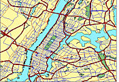
The figure below shows nyc_mainroads at a scale of 1:200000. Note that in the legend the layer is listed as "Roads".
|
Nyc_roads
The nyc_roads layer contains all the streets for New York City and the surrounding area. In the map configuration file, the LAYER maxscale is set to 1:35000 and does not turn on until a user zooms past a scale of 1:35000.Using SIMPLERENDERER
|
<LAYER type="featureclass" name="Roads" visible="true" id="4" maxscale="1:35000"> <DATASET name="nyc_roads" type="line" workspace="shp_ws-0" /> ... </LAYER> |
The nyc_roads layer uses two SCALEDEPENDENTRENDERERs depending on the current scale. At a scale between 1:21300 and 1:35000, the roads are rendered in a less detailed manner. When the scale is less than 1:21300, the road rendering becomes much more detailed. A third SCALEDEPENDENTRENDERER is used for labeling. The labels do not turn on until the scale is less than 1:25000. The SCALEDEPENDENTRENDERERs are grouped together inside a GROUPRENDERER.
Using SCALEDEPENDENTRENDERER
|
<LAYER�> <GROUPRENDERER> <SCALEDEPENDENTRENDERER lower="1:21300"> �less detailed rendering� </SCALEDEPENDENTRENDERER> <SCALEDEPENDENTRENDERER upper="1:21300"> �more detailed rendering� </SCALEDEPENDENTRENDERER> <SCALEDEPENDENTRENDERER upper="1:25000"> �label rendering� </SCALEDEPENDENTRENDERER> </GROUPRENDERER> </LAYER> |
The first SCALEDEPENDENTRENDERER with the less detailed rendering has a minimum scale set to 1:21300 (lower="1:21300"). The VALUEMAPRENDERER divides the roads into two categories based on the value in the field ROAD_TYPE: Freeway and Street. The freeways are a thick red line, and the streets are a thin blue line.
Using SCALEDEPENDENTRENDERER for nyc_roads when the scale is greater than 1:21000
|
<SCALEDEPENDENTRENDERER lower="1:21300" > <VALUEMAPRENDERER lookupfield="ROAD_TYPE"> <EXACT value="Freeway"> <SIMPLELINESYMBOL type="solid" width="3" color="255,0,0" /> </EXACT> <EXACT value="Street"> <SIMPLELINESYMBOL type="solid" width="1" color="0,0,255" /> </EXACT> </VALUEMAPRENDERER> </SCALEDEPENDENTRENDERER> |
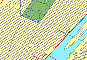
The figure below shows the map at a scale of 1:30000.
|
When the scale passes 1:21300, the second SCALEDEPENDENTRENDERER with more detailed rendering becomes active. Inside this SCALEDEPENDENTRENDERER is a group of VALUEMAPRENDERERs.
- The first VALUEMAPRENDERER uses the two categories of Street and Freeway. The streets are a thick solid white line eight pixels wide. The freeways are a multipart line symbol. The base level of the Freeway is included inside this renderer and is a black line nine pixels wide.
- The remaining three VALUEMAPRENDERERs create the rest of the multipart freeway symbol: red as the second layer seven pixels wide, black as the third layer three pixels wide, and white as the top layer one pixel wide.
|
<SCALEDEPENDENTRENDERER upper="1:21300"> <GROUPRENDERER> <VALUEMAPRENDERER lookupfield="ROAD_TYPE"> <EXACT value="Freeway"> <!--black--> <SIMPLELINESYMBOL type="solid" width="9" color="0,0,0" /> </EXACT> <EXACT value="Street"> <SIMPLELINESYMBOL type="solid" width="8" color="255,255,255" /> </EXACT> </VALUEMAPRENDERER> <VALUEMAPRENDERER lookupfield="ROAD_TYPE"> <EXACT value="Freeway"> <!--red--> <SIMPLELINESYMBOL type="solid" width="7" color="255,0,0" /> </EXACT> </VALUEMAPRENDERER> <VALUEMAPRENDERER lookupfield="ROAD_TYPE"> <EXACT value="Freeway"> <!--black--> <SIMPLELINESYMBOL type="solid" width="3" color="0,0,0" /> </EXACT> </VALUEMAPRENDERER> <VALUEMAPRENDERER lookupfield="ROAD_TYPE"> <EXACT value="Freeway"> <!--white--> <SIMPLELINESYMBOL type="solid" width="1" color="255,255,255" /> </EXACT> </VALUEMAPRENDERER> </GROUPRENDERER> </SCALEDEPENDENTRENDERER> |
The third SCALEDEPENDENTRENDERER is used to set the scale for labeling. In this layer, VALUEMAPLABELRENDERER becomes active when the scale is less than 1:25000. The streets and freeways both use TEXTSYMBOL, but the instructions for drawing the labels are different. Freeways use a bold Arial font with glow. Streets use a bold Arial font without the glow.
Labeling for nyc_roads
|
<SCALEDEPENDENTRENDERER upper="1:25000"> <VALUEMAPLABELRENDERER lookupfield="ROAD_TYPE" labelfield="NAME" linelabelposition="placeontop" howmanylabels="One_label_per_name"> <EXACT value="Freeway"> <TEXTSYMBOL font="Arial" fontsize="14" fontstyle="bold" fontcolor="0,0,255" glowing="153,153,153"/> </EXACT> <EXACT value="Street"> <TEXTSYMBOL font="Arial" fontsize="14" fontstyle="bold" fontcolor="0,0,0" /> </EXACT> </VALUEMAPLABELRENDERER> </SCALEDEPENDENTRENDERER> |
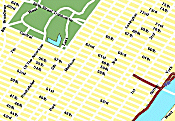
The following figure shows the detailed streets and freeways at a scale of 1:20000. At this scale, the labels are also included.
|
This case study shows different ways to use the ArcXML renderers. In summary, the basic rules for using these renderers are:
- Only one symbol can be used inside a renderer.
- SIMPLERENDERER and SIMPLELABELRENDERER are used when an entire layer is symbolized or labeled the same way.
- VALUEMAPRENDERER and VALUEMAPLABELRENDERER are used when different categories based on a value in a field are used to symbolize and label a layer.
- Two or more renderers are grouped together using GROUPRENDERER.
- Multiple GROUPRENDERERs can exist within other GROUPRENDERERs.
- SCALEDEPENDENTRENDERER is used to set scales for changing a layer's symbolization and labeling.