| Using the Java Viewer toolbar | |
| Using the Java Viewer toolbar | |
The toolbar is oriented horizontally in the Java Standard Viewer and vertically in the Java Custom Viewer. The Java Standard Viewer toolbar is shown here. Minor differences exist between the two toolbars and the Java Custom toolbar will contain only the tools you specified when you designed your Web site. Differences are noted in the following tool descriptions.
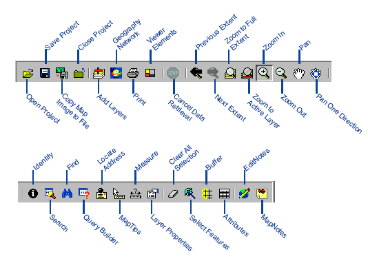
Open Project: Opens an existing configuration file.
Save Project: Saves the map as a configuration file.
Copy Map Image to File: Saves your current view as a JPEG image.
Close Project: Closes the current project and leaves the browser window open.
Add Layers: Opens a Catalog to navigate to data to add to the map.
Geography Network: Opens the Geography Network Explorer to search for data to add to the map.
Print: Prints the map to your default printer.
Viewer Elements: Changes the display properties of the scale bar, legend, and overview map. Not available in the Java Custom Viewer.
Cancel Data Retrieval: Cancels a request sent to the Spatial Server. Not available in the Java Custom Viewer.
Previous Extent: Zooms to the last extent.
Next Extent: Zooms forward from a previous extent. This tool is unavailable until you have clicked the Previous Extent button.
Zoom to Full Extent: Zooms to the full extent of the map.
Zoom to Active Layer: Zooms to the full extent of the active layer.
Zoom In: Zooms in to the area of the map that you click or drag a box around.
Zoom Out: Zooms out from the area of the map that you click or drag a box around.
Pan: Pans the display in the direction you drag the mouse pointer.
Pan One Direction: Pans the map in one direction. Available as four tools on the Java Custom Viewer toolbar - Pan to North, Pan to South, Pan to East, and Pan to West.
Identify: Displays the attributes of the feature you click.
Search: Searches for features based on the information you enter.
Find: Finds map features matching the string that you type.
Query Builder: Builds query expressions to search for features.
Locate Address: Locates a street address on the map.
MapTips: Displays information about a feature when the mouse pointer hovers over it.
Measure: Measures distances on the map.
Layer Properties: Sets the display properties of the active layer.
Clear All Selection: Clears the selected set of features from the map.
Select Features: Selects features contained within or intersected by a graphic you draw on the map. Available as four tools on the Java Custom Viewer toolbar - Select by Rectangle, Select by Circle, Select by Line, and Select by Polygon.
Buffer: Finds the features of one layer within a set buffer distance of the selected features of another layer.
Attributes: Displays tabular information about selected features.
EditNotes: Opens the EditNotes toolbar.
MapNotes: Opens the MapNotes toolbar.