GPS Quality, Capture, and Alerts options


GPS Quality, Capture, and Alerts options |
|
| Release 8 |
|
ArcPad includes a number of user-specified options that can be used to control which of the incoming GPS coordinates are used for creating and editing features. You can use these options to ensure that ArcPad only uses those GPS coordinates that meet your accuracy requirements for data capture. ArcPad uses the specified options to filter the incoming GPS coordinates and ignores those coordinates that do not meet the requirements. The specified options have no influence on how the GPS receiver actually computes the position coordinates, nor do they affect the way ArcPad displays the GPS position or coordinates, in the GPS Position Window, for example.
The GPS Quality, Capture, and Alerts options can be specified in the respective pages in the GPS Preferences dialog box.
The Quality options allow you to specify the following parameters:
Suitable maximum values will depend on the environment in which you are using the GPS receiver. For example, a PDOP of 5 could be appropriate when working in an open field but may be too low when working in an urban environment. It is best to refer to your GPS receiver’s manual for an appropriate maximum PDOP or EPE value. In general, a maximum PDOP value of 6 is acceptable.
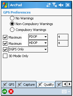
More than one quality parameter can be active at any time. A quality parameter is active when the parameter’s check box is checked and either Non-Compulsory or Compulsory Warnings have been selected.
The GPS Quality options are enabled, or disabled, by selecting one of three different warning levels:
The Non-Compulsory and Compulsory Warnings message boxes are only displayed when ArcPad is in the process of using the incoming GPS coordinates for creating or editing a point or vertex. However, the corresponding alerts for each of the four Quality parameters can be activated at any time if the Non-Compulsory or Compulsory Warnings have been selected.
The Capture options allow you to specify position averaging and streaming interval parameters.
The averaging parameters specify the number of incoming GPS position coordinates that ArcPad should use for calculating an average coordinate. The resultant average coordinate is then used by ArcPad for creating the point or vertex. The number of positions to average can be specified for points and vertices. Averaging is enabled when the Enable Averaging check box is checked.
It is best that you refer to your GPS receiver’s manual for an appropriate number of GPS positions to average; however, it is recommended that you average at least 20 GPS positions and preferably up to 180 positions.
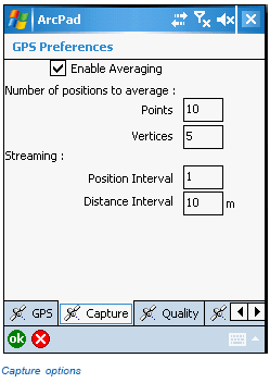
The Streaming Vertices Interval parameters allow you to specify how frequently ArcPad should use the incoming GPS coordinates when creating vertices with the Add GPS Vertices Continuously tool. For example, a Position Interval of 2 means that ArcPad will use every second-incoming GPS coordinate when creating vertices. The default Position Interval is 1. A Distance Interval of 2 means that ArcPad will only use the incoming GPS coordinate when the distance from the last coordinate is 2 meters or more.
A dialog box is automatically displayed each time ArcPad averages GPS coordinates. The dialog box shows a progress bar, which counts down from the specified number of GPS positions to average to zero. For example, the following dialog box is displayed while averaging to create a vertex:
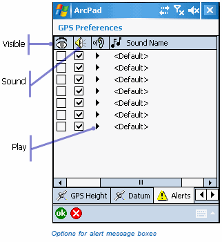
The Alerts options allow you to specify which message boxes are displayed and which sounds are played when an alert condition is encountered by ArcPad.
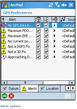
You can enable the following alerts:
The alert message boxes are enabled by checking the alert’s visible check box. The sounds are enabled by checking the alert’s sound check box. You can enable the message box or sound or both for any number of alerts. The Play button plays the sound for the associated alert. You can change the sound for any alert by tapping on the alert’s Sound Name column and selecting a Wave Sound (*.wav) file located on your computer.
The ArcPad Reference Guide provides more information on the GPS Quality, Capture, and Alerts options for ArcPad.