Show Navigation
|
Hide Navigation
Using the station and offset computation |
|
|
Release 9.1
Last modified April 26, 2005 |


|
Related Topics
About using the station and offset computation
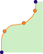
The station and offset computation can be used for calculating the coordinates along a path. A path is defined as:
- A straight line between two existing survey points.
- A sequence of connected feature segments starting and ending at survey points.
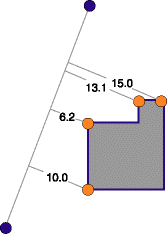
Coordinates can optionally be calculated perpendicular, at a specific offset distance left or right of the path you've specified. Offsets to the left must be entered as negative values, and offsets to the right must be entered as positive values.
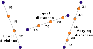
Different methods for computing these coordinates are available.
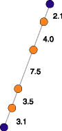
They can be computed at equal distances along the path, at varying distances, or so that they divide the given path into a specific number of equal lengths.
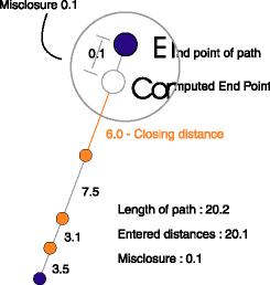
When using the variable distances method, you can choose to enter a closing distance. This is the distance from the last point computed to the endpoint of the path.
The difference between the sum of all the distances that you enter and the path length is called the distance misclosure or remainder. You can choose to proportion this remainder for each distance and compute new coordinate locations for the points.
For more information about entering point names, distances, and offsets in the station offset computation, see 'Computing coordinates offset left and right from a line between two points', below.
How to use the station and offset computation
Computing coordinates evenly spaced on a line between two existing points
- On the Editor toolbar, click the Editor menu and click Snapping. Click Survey Points in the Snapping Environment window.
- Click the Project dropdown arrow on the Survey Editor toolbar, then click the survey project that should own the measurement, point, and computation survey objects.
- Click the Computation tool palette dropdown arrow, move the cursor to the fourth row of buttons on the palette, and click the Station and Offset button
 .
. - Snap to and click the from point on the map.
- If the point is not visible on the map, type its name, and press Tab.
- Repeat step 4 to define the to Point and press Tab.
- Click the Stationing Type dropdown arrow, click Spaced evenly, then press Tab.
- Type the number of equal segments you want to use to divide the line and press Tab. The grid updates with a new row for each of the new points.
- Press Tab to ignore offset distances, press Tab to accept the default name, or type a new name and press Tab.
- Repeat step 9 for each of the new points in each row.
The name of the point appears in the From Point field.
Computing coordinates offset left and right from a line between two points
- Click the Computation tool palette dropdown arrow, point the mouse to the fourth row on the palette, and click the Station and Offset button .
- Snap to and click the from point on the map.
- The point name appears in the from Point field.
- If the point is not visible on the map, type its name in the text box. Press Tab.
- Repeat step 2 to define the to Point and press Tab.
- Click the Stationing Type dropdown arrow and click Variable distances. Press Tab.
- Type the distance along the line measured from the previous point and press Tab (the first distance starts at the from point).
- Type the first perpendicular offset distance in the Offset field. Press Tab.
- Accept the default name in the point identifier field or type the new name. Press Enter.
- Repeat steps 7 through 9 for each distance and offset along the line that you want to enter.
| Tip |
|
Proportioning the remainder when computing points on line
- Start a new station and offset computation.
- Choose the from point and to point.
- Click the Stationing Type dropdown arrow. Click Variable distances and press Tab.
- Type the distance along the line measured from the previous point in the Value field and press Tab (the first distance starts at the from point).
- Type an offset value, if required, and press Tab.
- In the Point identifier field, accept the default name or type the new name and press Enter.
- Repeat steps 4 through 6 for each distance and offset along the line that you want to enter.
- Check Proportion after you have entered the closing distance.
The points are recomputed; the remainder is distributed equally in each of the original distance measurements.
Computing coordinate locations along a feature segment path
- Identify the connected feature segments along which you want to create new survey points.
- Unless they already exist, digitize two new survey points, snapping to the first and last feature vertices that define the segment path.
- Start a new station and offset computation.
- Click the Editor menu on the Editor toolbar and click Snapping.
- Check Edge for the feature class that represents the feature that holds the feature segment path.
- Make sure the from point or to point field has focus, snap to, and click a segment on the path.
- Click the Stationing Type dropdown arrow, click the method you want to use, then press Tab.
- Enter point names, distances, and offsets, if required.