Buffer (Analysis) |
|
|
Release 9.1
Last modified August 15, 2005 |


|
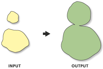
Creates buffer polygons to a specified distance around the Input Features. An optional dissolve can be performed to remove overlapping buffers.
Learn more about how Buffer works
Illustration
Usage tips
-
Features will not be buffered if their buffer distance is zero. If you don't want to have a feature buffered in the Output Feature Class, assign it a buffer distance value of zero in the distance field.
-
Negative distances can be used when buffering polygon features, to create buffers on the inside of the polygon features. Using a negative value will shrink the output polygon feature by the distance specified.
-
The LEFT and RIGHT options generate buffers at the topological left or right of a line. Caution must be exercised in interpreting the left or right side of a polyline. With connecting polylines, the left side of one polyline may be on the right side of another connecting polyline.
-
Using the Dissolve Type parameter ALL option will dissolve all buffer polygons into a single multipart polygon feature. Buffers of related features can be dissolved together using the Dissolve Type parameter LIST option and a set of fields for Dissolve Fields. Buffer features with the same values in their Dissolve Fields will be dissolved together.
-
Using ALL or LIST for the Dissolve parameter may result in multipart features being created.
-
The Side Type and End Type parameters apply only to line features.
-
Side Type's LEFT and RIGHT options and End Type's FLAT option are only available with an ArcInfo licence.
-
Buffer will expand the XYDomain of the Output Feature Class to accommodate potential buffer features beyond the Input Feature's XYDomain.
-
The projection will be copied to the Output Feature Class.
-
The Dissolve Fields parameter Add Field button is used only in ModelBuilder. In ModelBuilder, where the preceding tool has not been run, or it's derived data does not exist, the Dissolve Fields parameter may not be populated with field names. The Add Field button allows you to add expected fields so you can complete the Buffer dialog and continue to build your model. Learn more about the Add Field button
-
The following environments affect this tool: configKeyword, extent, MDomain, outputCoordinateSystem, outputMFlag, outputZFlag, outputZValue, scratchWorkspace, spatialGrid1, spatialGrid2, spatialGrid3, workspace, XYDomain, and ZDomain.
Command line syntax
Introducing geoprocessing methods—Using dialog boxes and the command line
Buffer_analysis <in_features> <out_feature_class> <buffer_distance_or_field> {FULL | LEFT | RIGHT} {ROUND | FLAT} {NONE | ALL | LIST} {dissolve_field;dissolve_field...}
| Parameter | Explanation |
| <in_features> |
The features to be buffered. |
| <out_feature_class> |
The feature class that will contain the buffer features. |
| <buffer_distance_or_field> |
The distance used to create buffer zones around Input Features. Either a value or a numeric field can be used to provide buffer distances. |
| {FULL | LEFT | RIGHT} |
The side(s) of a line that will be buffered.
The LEFT and RIGHT options are not available with an ArcView or ArcEditor license. |
| {ROUND | FLAT} |
For lines, the shape of the buffer at the line end points.
|
| {NONE | ALL | LIST} |
Specifies whether a dissolve will be performed to remove buffer feature overlap.
|
| {dissolve_field;dissolve_field...} |
List of field(s) for the dissolve. Buffer polygons that share the same set of values in their Dissolve Field(s) will be dissolved together. The Add Field button, which is used only in ModelBuilder, allows you to add expected field(s) so you can complete the dialog and continue to build your model. |
Command line example
Buffer_analysis c:\basedata\road.shp c:\basedata\buffered_roads.shp '200 Feet' FULL FLAT
Scripting syntax
Introducing geoprocessing methods—Running a script
Buffer_analysis (in_features, out_feature_class, buffer_distance_or_field, line_side, line_end_type, dissolve_option, dissolve_field)
| Parameter | Explanation |
| in_features (Required) |
The features to be buffered. |
| out_feature_class (Required) |
The feature class that will contain the buffer features. |
| buffer_distance_or_field (Required) |
The distance used to create buffer zones around Input Features. Either a value or a numeric field can be used to provide buffer distances. |
| line_side (Optional) |
The side(s) of a line that will be buffered.
The LEFT and RIGHT options are not available with an ArcView or ArcEditor license. |
| line_end_type (Optional) |
For lines, the shape of the buffer at the line end points.
|
| dissolve_option (Optional) |
Specifies whether a dissolve will be performed to remove buffer feature overlap.
|
| dissolve_field (Optional) |
List of field(s) for the dissolve. Buffer polygons that share the same set of values in their Dissolve Field(s) will be dissolved together. The Add Field button, which is used only in ModelBuilder, allows you to add expected field(s) so you can complete the dialog and continue to build your model. |
Script example
import win32com.client
gp = win32com.client.Dispatch("esriGeoprocessing.GPDispatch.1")
gp.workspace = "c:/basedata"
gp.toolbox = "analysis"

# Buffer roads.shp based on each road feature's value in the Distance field, and dissolve buffers into
# groups according to values from Road_Type field.
gp.buffer("roads.shp", "buffered_roads.shp", "Distance", "FULL", "ROUND", "LIST", "Road_Type")