Geoprocessing tool reference > Data Management toolbox > Raster toolset > Tools
Clip (Data Management) |
|
|
Release 9.1
Last modified June 25, 2007 |


Print all topics in : "Tools" |
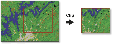
Creates a spatial subset of a raster dataset. The clipped area is specified by a rectangular envelope.
The rectangular envelope extents are specified using minimum and maximum x and y coordinates.
Illustration
Usage tips
-
The Clip tool allows you to extract a portion of a raster dataset based on a rectangular extent.
-
The minimum and maximum x and y extents allow you to define the clip extents for your output raster dataset.
-
The extent values must be in the same spatial coordinates and units as the raster dataset.
-
The Clip tool allows you to extract a portion of a raster dataset based on a rectangular extent.
-
The envelope defines the clip extent for your output raster dataset. The envelope values represent the lower left coordinate's x value and y value, then the upper right coordinate's x value and y value.
-
The extent values must be in the same spatial coordinates and units as the raster dataset.
-
The output raster will have the same cellsize as the input raster.
ArcObjects
Command line syntax
Introducing geoprocessing methods—Using dialog boxes and the command line
Clip_management <in_raster> <rectangle> <out_raster>
| Parameter | Explanation |
| <in_raster> |
Input raster dataset. |
| <rectangle> |
The rectangle defining the area to be clipped. Define in this order: X-Minimum, Y-Minimum, X-Maximum, Y-Maximum. |
| <out_raster> |
Output raster dataset. When not saving to a geodatabase, specify .tif for a TIFF file format, .img for an ERDAS IMAGINE file format, or no extension for a GRID file format. |
Command line example
Clip_management D:\images\OverviewImage\Layer_1 '549790 5272863 549870 5273000' D:\images\ClippedOverview1
Scripting syntax
Introducing geoprocessing methods—Running a script
Clip_management (in_raster, rectangle, out_raster)
| Parameter | Explanation |
| in_raster (Required) |
Input raster dataset. |
| rectangle (Required) |
The rectangle defining the area to be clipped. Define in this order: X-Minimum, Y-Minimum, X-Maximum, Y-Maximum. |
| out_raster (Required) |
Output raster dataset. When not saving to a geodatabase, specify .tif for a TIFF file format, .img for an ERDAS IMAGINE file format, or no extension for a GRID file format. |
Script example
from win32com.client import Dispatch
gp = Dispatch('esriGeoprocessing.GpDispatch.1')
gp.workspace = "c:/seattle_data"
gp.Clip_management("seattle1.tif","549790.051000 5272863.993000 549870.051000 5273000.993000","seattle_clip.img")
Map Algebra syntax
Not available.
ArcObjects syntax
ITransformationOp::Clip(GeoDataset As IGeoDataset, Rectangle As IEnvelope) As IGeoDataset
| Parameter | Explanation |
| GeoDataset | An input Raster, RasterDataset RasterBand or RasterDescriptor. |
| Rectangle | An IEnvelope identifying the lower-left and upper-right coordinates of the rectangle defining the area to be subset from the input GeoDataset. |
ArcObjects example
'Function Clip(ByVal GeoDataset As esriGeoDatabase.IGeoDataset, _' ByVal Rectangle As esriGeometry.IEnvelope) _
' As esriGeoDatabase.IGeoDataset
' Member of esriGeoAnalyst.ITransformationOp
Dim pTransformationOp As ITransformationOp
Set pTransformationOp = New RasterTransformationOp
' Get raster
Dim pRas01 As IRaster
Set pRas01 = getRasterFromDiskFunction("c:\data\myRaster")
' Declare an envelope object
Dim pEnvelope As IEnvelope
' Create an envelope
Set pEnvelope = New Envelope
pEnvelope.PutCoords 1, 1, 3, 3
Dim pGeoDS As IGeoDataset
Set pGeoDS = pTransformationOp.Clip(pRas01, pEnvelope)