Extensions > 3D Analyst > Getting started with 3D Analyst
An overview of 3D Analyst |
|
|
Release 9.1
Last modified January 17, 2008 |


Print all topics in : "Getting started with 3D Analyst" |
The ArcGIS 3D Analyst extension provides tools for three-dimensional (3D) visualization, analysis, and surface generation.
With 3D Analyst, users can:
- View a surface from multiple viewpoints.
- Query a surface.
- Create realistic perspective imaging.
- Examine the visual impact of building new structures.
- Analyze atmospheric, surface, and subsurface pollution dispersion.
- Visualize the income distribution in their community.
3D Analyst also provides tools for three-dimensional modeling and analysis, such as viewshed and line-of-sight analysis; spot height interpolation; profiling; steepest path determination; and contouring.
ArcScene
3D Analyst adds a specialized 3D viewing application, ArcScene, to your desktop, extending ArcCatalog and ArcMap so you can more effectively manage your 3D GIS data, perform 3D analysis, edit 3D features, and create layers with 3D viewing properties. You can create 3D features from existing two-dimensional (2D) GIS data, or you can digitize new 3D vector features and graphics in ArcMap using a surface to provide the z-values.
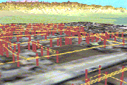
ArcScene allows you to make realistic scenes in which you can navigate and interact with your GIS data, as in the following 3D view of utility poles and power lines.
Learn more about ArcScene
In ArcCatalog, the 3D Analyst extension allows you to manage 3D GIS data and create layers with 3D viewing properties. You can preview scenes and data in 3D in ArcCatalog using the same 3D navigation tools you use in ArcScene.
Learn more about 3D Analyst capabilities in ArcCatalog
In ArcMap, the 3D Analyst extension allows you to create new surfaces from your GIS data as well as analyze surfaces, query attribute values at a location on a surface, and analyze the visibility of parts of a surface from different locations. You can also determine the surface area and the volume above or below a surface and create profiles along a 3D line on a surface.
Learn more about 3D Analyst capabilities in ArcMap
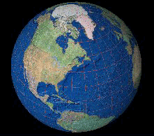
3D Analyst adds another specialized 3D viewing application, ArcGlobe, to your desktop. ArcGlobe gives you a new and unique way to view and analyze your GIS data. Spatially referenced data is placed on a 3D globe surface, displayed in its true geodetic location. You can manipulate the globe, then investigate and analyze its data while viewing the globe as a whole, or regions within it. You can view data covering a global extent then seamlessly zoom into highly detailed, localized data. ArcGlobe gives you the power to tame voluminous data while fully employing all information the data can give you. ArcGlobe allows efficient display and query of raster data and is integrated to function with the ArcGIS geodatabase while providing support for analysis in the geoprocessing environment.