Geoprocessing tool reference > 3D Analyst toolbox > TIN Surface toolset
Measuring aspect |
|
|
Release 9.2
Last modified November 22, 2006 |


Print all topics in : "TIN Surface toolset" |
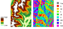
Aspect is the direction that a slope faces. It identifies the steepest downslope direction at a location on a surface. It can be thought of as slope direction or the compass direction a hill faces. Aspect is calculated for each triangle in TINs and for each cell in rasters.
How is aspect measured?
Aspect is measured counterclockwise in degrees from 0 (due north) to 360 (again due north, coming full circle). The value of each cell in an aspect grid indicates the direction in which the cell's slope faces. Flat slopes have no direction and are given a value of -1.
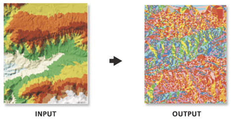
The following shows an input elevation grid and the output aspect grid.
Why use the aspect function?
There are many different reasons to use the aspect function. For instance, you may want to:
- Find all north facing slopes on a mountain as part of a search for the best slopes for ski runs.
- Calculate the solar illumination for each location in a region as part of a study to determine the diversity of life at each site.
- Find all southerly slopes in a mountainous region to identify locations where the snow is likely to melt first as part of a study to identify those residential locations that are likely to be hit by runoff first.
- Identify areas of flat land to find an area for a plane to land in case of emergency.