About 3D symbols |
|
|
Release 9.2
Last modified February 29, 2008 |


|
A 3D symbol is a 2D symbol with extended properties. These properties enhance 2D symbols so they can be viewed in 3D in an ArcGIS 3D application. You can use 3D symbols to bring more realism to your documents or help portray 2D map symbols in 3D. Use 3D symbols to create geotypical worlds, geospecific worlds, or 3D maps.
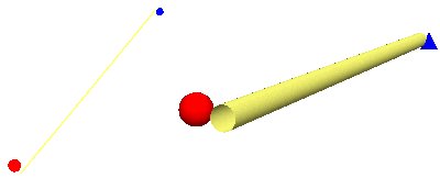
While a 2D symbol has dimensions in the x and y directions, a 3D symbol has the additional property of a dimension in the z direction. Thus, a 2D point symbol is analogous to a 3D sphere symbol, a square-shaped 2D symbol is analogous to a cube-shaped 3D symbol, and a 2D line symbol can be analogous to a tube-shaped 3D symbol.
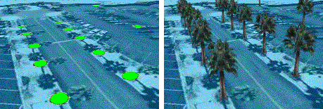
3D symbols can also be more complex than simple geometric shapes. A 2D picture fill symbol, whose pattern is applied as a fill to a 2D polygon, is analogous to a 3D texture fill symbol. A 3D texture fill symbol is a picture fill symbol that has awareness of its real-world size and can be mapped to a geometry with proper scaling. Points may also be symbolized by representations of real-world objects (3D models) as, for example, a set of points indicating tree locations being symbolized by a 3D model of a palm tree.
Types of 3D symbols
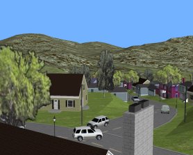
A point can be symbolized in 3D by a simple 3D marker, such as a cube or a cone; a 3D character marker based on a system font; or a 3D marker as imported from a 3D model. A line can be symbolized in 3D by using a 3D simple line symbol, such as a tube or a strip, or a texture line symbol, such as a texture symbolizing a road. A polygon or surface can be symbolized by using a 3D texture fill symbol, for example, a texture resembling a geotypical feature, such as grass. These options allow you to render realistic 3D worlds. For example, you may have an existing document that could be made more visually realistic by symbolizing points representing a housing tract by 3D models of houses, then symbolizing the roads in this tract by using a textured line symbol that models pavement. In addition, you might use a grass texture to symbolize a polygon feature class showing city parks.
Geotypical documents
A geotypical symbol is a model with realistic properties that are used to portray a certain style. A set of geotypical models might show a generic style or theme, such as Cape Cod houses with different properties, such as 1 story or 2 story. ArcGIS 3D Analyst comes with 3D styles that allow you to symbolize points, lines, and polygons with generic 3D symbols, such as typical houses, textured roads, and fills. You can use these symbols to create realism, while still being abstract enough not to imply specific, actual objects. Use geotypical symbols to model a proposed housing tract or in existing areas where it isn't necessary to show real-world objects. Using geotypical 3D symbols, you can make documents that mimic real-world characteristics but don't imply visual truth.
Geospecific documents
A geospecific symbol is a model that is based on a real-world object. An example is a model of the White House in Washington, D.C. You can symbolize features with objects that are based on real-world objects. For example, if you have existing 3D models of buildings that exist in an area, you can import them, then render your point feature class with the objects you've imported. You can also import any textures that you may have, such as vegetation or wall textures. You can import these models into styles or as needed to symbolize features independent from a style.
3D maps
You can create dramatic maps that are rendered with 3D symbology. These may use a map's 2D symbology as a guide then display the symbols in 3D. For example, points can be displayed as spheres, lines as strips, and polygons as textured objects. In addition, you might choose a 3D character marker to render font-based characters in 3D. You can use these 3D representations to bring new perspectives to your maps.