Albers Equal Area Conic |
|
|
Release 9.2
Last modified August 3, 2007 |


|
Description
This conic projection uses two standard parallels to reduce some of the distortion of a projection with one standard parallel. Although neither shape nor linear scale is truly correct, the distortion of these properties is minimized in the region between the standard parallels. This projection is best suited for land masses extending in an east-to-west orientation rather than those lying north to south.
Projection method
Conic. The meridians are equally spaced straight lines converging to a common point. Poles are represented as arcs rather than as single points. Parallels are unequally spaced concentric circles whose spacing decreases toward the poles.
Lines of contact
Two lines, the standard parallels, defined by degrees latitude.
Linear graticules
All meridians.
Properties
Shape
Shape along the standard parallels is accurate and minimally distorted in the region between the standard parallels and those regions just beyond. The 90° angles between meridians and parallels are preserved, but because the scale along the lines of longitude does not match the scale along the lines of latitude, the final projection is not conformal.
Area
All areas are proportional to the same areas on the earth.
Direction
Locally true along the standard parallels.
Distance
Distances are most accurate in the middle latitudes. Along parallels, scale is reduced between the standard parallels and increased beyond them. Along meridians, scale follows an opposite pattern.
Limitations
Best results for regions predominantly east–west in orientation and located in the middle latitudes. Total range in latitude from north to south should not exceed 30–35°. No limitations on the east–west range.
Uses and applications
Used for small regions or countries but not for continents.
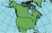
Used for the conterminous United States, normally using 29°30' and 45°30' as the two standard parallels. For this projection, the maximum scale distortion for the 48 states is 1.25 percent.
One method to calculate the standard parallels is by determining the range in latitude in degrees north to south and dividing this range by six. The "one-sixth rule" places the first standard parallel at one-sixth the range above the southern boundary and the second standard parallel minus one-sixth the range below the northern limit. There are other possible approaches.
Parameters
Desktop
- False Easting
- False Northing
- Central Meridian
- Standard Parallel 1
- Standard Parallel 2
- Latitude of origin
Workstation
- 1st standard parallel
- 2nd standard parallel
- Central Meridian
- Latitude of projections origin
- False Easting (meters)
- False Northing (meters)