Show Navigation
|
Hide Navigation
Converting a geodatabase to shapefiles |
|
|
Release 9.2
Last modified August 23, 2007 |


|
About converting a geodatabase to shapefiles
You can convert the feature classes in a geodatabase to individual shapefiles using the GDB To Shape tool.
How to convert feature classes to shapefiles
- Click the Start button, point to Programs, point to PLTS, and click GDB To Shape.
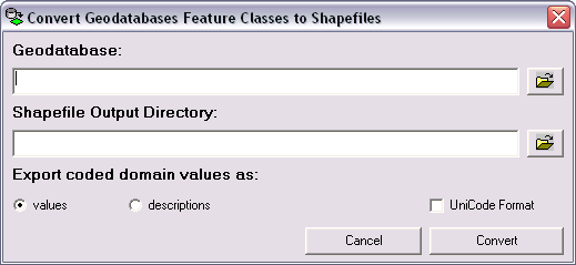
The Convert Geodatabase Feature Classes to Shapefiles dialog box appears. - Click the Browse button
 next to the Geodatabase field.
The Select the Workspace to load the data dialog box appears. - Navigate to the geodatabase you want to convert to shapefiles.
- Click Add.
The path for the geodatabase you chose appears in the Geodatabase field. - Click the Browse button next to the Shapefile Output Directory field.
The Browse for Folder dialog box appears. - Navigate to the directory where the generated shapefiles will be stored.
- Click OK.
The path for the directory you chose appears in the Shapefile Output Directory field. - Choose an option for exporting coded value domains.
The options are values and descriptions. Values will export the values for the subtypes and attributes. Descriptions exports the descriptions related to the attribute values. - If your geodatabase contains Unicode text attributes, check the UniCode Format check box.
This feature ensures that all the Unicode characters in your feature classes are converted correctly. - Click Convert.
The Select Feature Classes to Convert dialog box appears. - Check the check boxes next to the feature classes you want to convert.
You can click Select All and Select None to choose all or none of the feature classes, respectively. - Click OK.
The selected feature classes are converted to shapefiles. - Click Done.