Thinking about maps in web-enabled GIS applications |
|
|
Release 9.2
Last modified March 10, 2008 |


|
Maps provide a powerful metaphor to define and standardize how people use and interact with your geographic information. Interactive maps provide the primary user interface for most GIS applications. Users can point to locations and discover new relationships, perform editing and analysis, and effectively communicate results using geographic views such as maps and globes
Interactive maps, printed maps, three-dimensional (3D) scenes and globes, summary charts and tables, time-based views, and schematic views of networks are examples of how GIS users view and interact with geographic information.
The map service is the most common ArcGIS service to be published and contains a number of optional capabilities.
Many optional map service capabilities can be enabled by including certain content in your map document. For example, if you want to edit geodatabase layers in a web browser, you add them as map layers in ArcMap and publish the map as a web service. Understanding how to create GIS resources with certain capabilities helps you to leverage the power of ArcGIS Server.
ArcGIS Server supports a range of mapping applications. Each application provides a series of tools or functions that enable your users to perform a broad array of tasks and workflows. Each application helps your users get their work done using GIS.
GIS maps
You can think of a GIS map as an interactive map that you access and use on a computer or a mobile device. GIS maps extend traditional printed maps in several interesting ways:
- GIS maps are multi-scale. They can automatically display information at the appropriate level of detail as you zoom in and out on the map – from a "global" view" down to a "street level" or "city-block" view.
- GIS maps are interactive. You can often work with information ad hoc and add new layers of information as they become available.
- Each GIS map has a set of tools as part of its user interface that allow you to work with its contents. Capabilities can vary from common map query and identification tasks, to address geocoding, routing, data compilation and editing, and geographic analysis. Many maps contain focused, custom tools that help end users accomplish critical work tasks.
- GIS maps can be dynamic and animate the display of information through time.
- GIS maps come in many applications and map sizes and can be deployed as web maps, 3D maps, specialized map applications, and mobile maps in the field.
- GIS maps often fuse information from a range of GIS web services. The ability to integrate information and tools from multiple sources is quite powerful.
- GIS maps are flexible. A variety GIS map applications and frameworks support a range of deployment options.
Map applications used with ArcGIS Server
Users work with many types of GIS map applications in order to accomplish work tasks – for example, professional GIS maps, web maps, embedded maps, explorer maps, and mobile maps.
Each map type has a corresponding ArcGIS software application that is used to perform work tasks. Each ArcGIS map type is suitable for certain user audiences and supports specific work flows.
Professional GIS maps using ArcMap and ArcGlobe
ArcGIS Desktop users employ ArcMap and ArcGlobe to perform most GIS tasks -- mapping editing and data compilation, analysis, visualization, and map printing. ArcMap is the primary application used in ArcView, ArcEditor, and ArcInfo. This is also the environment used to author most of the content served using ArcGIS Server.
ArcGlobe is an applications that comes with the optional 3D Analyst extension to ArcGIS Desktop.
The ArcMap application that comes with ArcView, ArcEditor, and ArcInfo is shown above.
The ArcGlobe application that is part of the 3D Analysts extension is shown above.
Embedded maps using ArcGIS Engine
ArcGIS Engine is a GIS developer's toolkit for building custom applications using ArcObjects. For example, the parcel search application below was built using ArcGIS Engine.
Web maps
Most GIS is deployed out to users and the public using web browsers. Browser-based maps can be built using the Web Mapping Application that is included with ArcGIS Server and ArcIMS.
The Web Mapping Application is an out-of-the-box browser-based application that supports access to map services coming from ArcIMS, ArcGIS Server, and open OGC web services.
Mobile maps
Mobile maps are deployed in the field on a range of devices -- smart phones, Pocket PC's, and Tablet PC's. ArcGIS Server provides a range of mobile GIS services.
ArcGIS Mobile is a developer's toolkit that can be used to create and deploy focused mobile applications that operate in a "sometimes connected" environment and can be deployed to a large number of users.
These applications support mobile mapping, GPS, wireless synchronization, GIS data replication, and editing capabilities on a range of field devices running Microsoft Windows Mobile technology.
ArcGIS Mobile supports editing against versioned ArcSDE geodatabases in both connected and disconnected workflows. Periodically, you can synchronize updates directly with the ArcGIS Server without having to return to the office.
ArcGIS Server Mobile runs on a range of mobile devices: Smartphones, Pocket PC's, and Tablet PC's.
For more information, refer to the Microsoft Windows developer documentation for ArcGIS Server. Access the help system for "Developing Mobile Applications using the Mobile ADF."
ArcGIS Explorer maps
ArcGIS Explorer is a new geospatial information viewer, powered by ArcGIS Server. It offers a free, fast, and easy-to-use way to explore geographic information—in both 2D and 3D — with the ability to perform query and analysis tasks on the underlying data.
ArcGIS Explorer integrates server-based geoprocessing applications with GIS datasets by accessing the full GIS capabilities of ArcGIS Server, including geoprocessing and 3D services. ArcGIS Explorer can also use local data layers and services from ArcIMS, ArcWeb Services, OGC WMS, and Google KML, making it open and interoperable.
ArcGIS Explorer is free and can be downloaded and used by anyone for both personal as well as professional use without cost. ArcGIS Explorer is also included with ArcGIS Server.
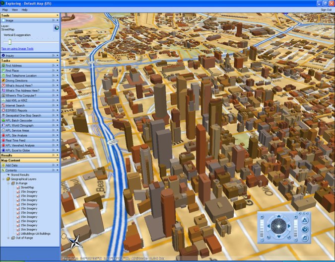
The view above illustrates the use of ArcGIS Explorer accessing globe services from ArcGIS Server. The globes are authored in ArcGIS Desktop and served as 3D basemaps. In addition, a series of geoprocessing services running in the server have also been published and are being accessed and custom tasks inside ArcGIS Explorer. These tasks were built for emergency response activities in and around Los Angeles.