Central Feature (Spatial Statistics) |
|
|
Release 9.2
Last modified January 9, 2009 |


|
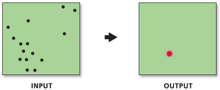
Identifies the most centrally located feature in a point, line, or polygon feature class.
Learn more about how Central Feature works
Illustration
Usage tips
-
The feature associated with the smallest accumulated distance to all other features is the most centrally located feature; this feature is selected and copied to the newly created output feature class (using Make Feature Layer and Save to Layer File).
-
For line and polygon features, feature centroids are used in the computations
-
Calculations are based on either Euclidean or Manhattan distance and require projected data to accurately measure distances.
-
Current map layers may be used to define the input feature class. When using layers, only the currently selected features are used in the Central Feature operation.
-
The following environment settings affect this tool: Extent, M Domain, Configuration Keyword, Coordinate System, Output has M Values, Output Spatial Grid, Output has Z Values, Default Z Value, Output XY Domain, and Output Z Domain.
Command line syntax
An overview of the Command Line window
CentralFeature_stats <Input_Feature_Class> <Output_Feature_Class> <Euclidean Distance | Manhattan Distance> {Weight_Field} {Self_Potential_Weight_Field}
| Parameter | Explanation | Data Type |
| <Input_Feature_Class> |
The feature class containing a distribution of features from which to identify the most centrally located feature. |
Feature Layer |
| <Output_Feature_Class> |
The feature class that will contain the most centrally located feature in the input feature class. |
Feature Class |
| <Euclidean Distance | Manhattan Distance> |
Specifies how distances are calculated when measuring concentrations.
|
String |
| {Weight_Field} |
The numeric field used to weight distances in the origin-destination distance matrix. |
Field |
| {Self_Potential_Weight_Field} |
The field representing self-potential — The distance or weight between a feature and itself. |
Field |
Command line example
CentralFeature e:\project93\data\hospitals.shp e:\project93\output\hosp_cf.shp 'Manhattan Distance' POP #
Scripting syntax
About getting started with writing geoprocessing scripts
CentralFeature_stats (Input_Feature_Class, Output_Feature_Class, Distance_Method, Weight_Field, Self_Potential_Weight_Field)
| Parameter | Explanation | Data Type |
| Input_Feature_Class (Required) |
The feature class containing a distribution of features from which to identify the most centrally located feature. |
Feature Layer |
| Output_Feature_Class (Required) |
The feature class that will contain the most centrally located feature in the input feature class. |
Feature Class |
| Distance_Method (Required) |
Specifies how distances are calculated when measuring concentrations.
|
String |
| Weight_Field (Optional) |
The numeric field used to weight distances in the origin-destination distance matrix. |
Field |
| Self_Potential_Weight_Field (Optional) |
The field representing self-potential — The distance or weight between a feature and itself. |
Field |
Data types for geoprocessing tool parameters
Script example
# Measure geographic distribution characteristics of coffee house locations weighted by the number of employees
# Import system modules
import arcgisscripting

# Create the Geoprocessor object
gp = arcgisscripting.create()

# Local variables...
workspace = "C:/data"
input_FC = "coffee_shops.shp"
CF_output = "coffee_CF.shp"
MC_output = "coffee_MC.shp"
weight_field = "NUM_EMP"

try:
    # Set the workspace to avoid having to type out full path names
    gp.workspace = workspace

    # Process: Central Feature...
    gp.CentralFeature_stats(input_FC, CF_output, "Euclidean Distance", weight_field, "#")

    # Process: Mean Center...
    gp.MeanCenter_stats(input_FC, MC_output, weight_field, "#", "#")

except:
    # If an error occurred when running the tool, print out the error message.
    print gp.GetMessages()