Geoprocessing tool reference > Data Management toolbox > Generalization toolset > Tools
Collapse Dual Lines To Centerline (Data Management) (ArcInfo only) |
|
|
Release 9.2
Last modified November 29, 2010 |


Print all topics in : "Tools" |
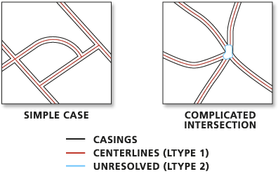
Derives centerlines from dual-line (or double-line) features, such as road casings, based on specified width tolerances.
Illustration
Usage tips
-
This tool is designed to work with fairly regular, near parallel pairs of lines, such as large-scale road casings. Centerlines will be created only between open-ended lines, not inside closed lines which are likely street blocks.
-
Centerlines will be derived based on the specified width parameters. A dual-line feature wider than the Maximum Width or narrower than the Minimum Width will not be centerlined. Use known road widths if available. However, since casings usually become wider at intersections, set the Maximum Width slightly greater than the known maximum width. You may need to experiment to find suitable parameters.
-
The output feature class will not carry the geographic attributes from the input lines, but contain the following three new fields:
- LnType — Contains the following line type values:
- value of 1 for derived centerlines
- value of 2 for outlines around relatively complicated intersections where centerlines are not generated, lines representing roads with a width beyond the specified range, and other broken or unpaired lines.
- value of 3 for lines with unclear source casings (they usually connect two closely located intersections which may belong to one large intersection in reality.)
- LeftLn_FID — Carries the object ID of the input line to the left of a derived centerline. This field value will be zero for lines of LnType 2 and 3.
- RightLn_FID — Carries the object ID of the input line to the right of a derived centerline. This field value will be zero for lines of LnType 2 and 3.
You can use the LnType values to further inspect the unresolved intersections and wider roads; and you can use the LeftLn_FID and RightLn_FID fields and other geoprocessing tools to transfer the attributes as needed.
-
Since the tool is not designed for natural features, such as irregularly shaped double-line rivers, you may get unexpected results if you apply it to such features. The tool may also produce unexpected results if you apply it to relatively smaller-scale road data, such as multiple-lane highways with interchanges, ramps, overpasses and underpasses, or railways with multiple, merging tracks.
-
The following environment settings affect this tool: XY tolerance, Extent, M domain, Coordinate system, Output has M values, Output has Z values, Default Z value, Output XY domain, workspace, and scratch workspace.
Command line syntax
An overview of the Command Line window
CollapseDualLinesToCenterline_management <in_features> <out_feature_class> <maximum_width> {minimum_width}
| Parameter | Explanation | Data Type |
| <in_features> |
The input dual-line features, such as road casings, from which centerlines are derived. |
Feature Layer |
| <out_feature_class> |
The output feature class to be created. |
Feature Class |
| <maximum_width> |
Sets the maximum width of the dual-line features to derive centerline. A value must be specified, and it must be greater than zero. You can specify a preferred unit; the default is the feature unit. |
Linear unit |
| {minimum_width} |
Sets the minimum width of the dual-line features to derive centerline. The minimum width must be greater than or equal to zero, and it must be less than the maximum width. The default value is zero. You can specify a preferred unit; the default is the feature unit. |
Linear unit |
Command line example
collapseduallinestocenterline_management c:\mapData.mdb\roads c:\mapDataNew\centerlines 100 0
Scripting syntax
About getting started with writing geoprocessing scripts
CollapseDualLinesToCenterline_management (in_features, out_feature_class, maximum_width, minimum_width)
| Parameter | Explanation | Data Type |
| in_features (Required) |
The input dual-line features, such as road casings, from which centerlines are derived. |
Feature Layer |
| out_feature_class (Required) |
The output feature class to be created. |
Feature Class |
| maximum_width (Required) |
Sets the maximum width of the dual-line features to derive centerline. A value must be specified, and it must be greater than zero. You can specify a preferred unit; the default is the feature unit. |
Linear unit |
| minimum_width (Optional) |
Sets the minimum width of the dual-line features to derive centerline. The minimum width must be greater than or equal to zero, and it must be less than the maximum width. The default value is zero. You can specify a preferred unit; the default is the feature unit. |
Linear unit |
Data types for geoprocessing tool parameters
Script example
import arcgisscripting
gp = arcgisscripting.create()

gp.workspace = "h:\\workspace"
gp.toolbox = "management"
gp.collapseduallinestocenterline ("roads", "centerlines", "100")